The NOAA released several early winter outlooks, which assess temperature and precipitation for a 3 month period. For us skiers, the OND (October, November, December) and JFM (January, February, March) forecasts are most important! Scroll to the bottom for a TL;DR summary.
OND 2020 forecast analysis:
Temperature:
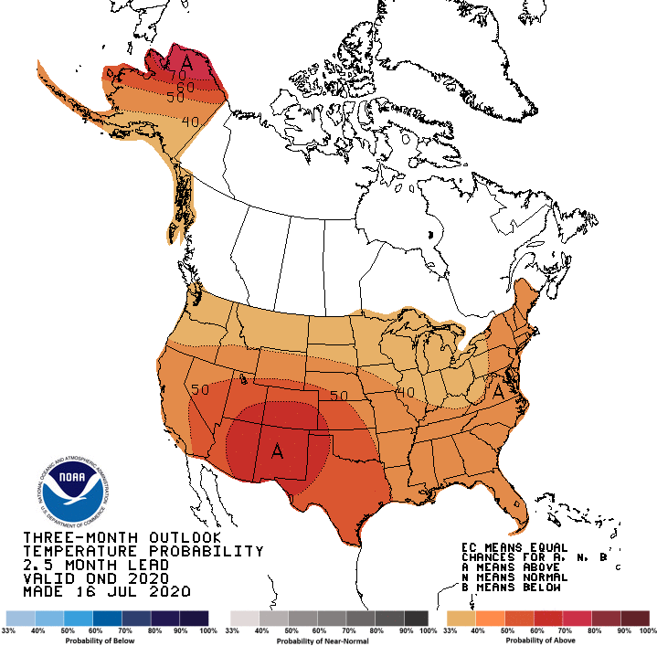
Let’s start off by analyzing the temperature forecast. The entire United States is expected to have above-average temperatures for October, November, and December. While this may seem bad, it might actually be a blessing in disguise.
When most mountainous regions get their first snowfalls in October and November, it is generally before consistent storm patterns dump continuous snow. This means that a region will usually have a couple of small storms in late October and November, and have a period of calm before the consistent snowfall begins in late November and December. This is very problematic for avalanches later in the season. The snow sits on the ground, and during the period before consistent snowfall, the cold, generally clear nights tend to facet the entirety of the shallow snowpack. In other words, the snow at the bottom of the snowpack will be the most unstable part of the snowpack, leading to huge avalanches resulting in the entire snowpack sliding later in the season. If you’d like to learn more about the science of facets, rounds, and other fancy avalanche terms, go check out this video that I made covering the basics of snow science.
So how is the above-average temperature a blessing in disguise? Well, if the temperature is high enough before the consistent snowfall, it may melt away the shallow snowpack, which will prevent unstable snow from being on the bottom of the snowpack, what we call an “upside-down snowpack.”
The higher temperatures across the US will likely also mean rain at lower elevations.
Precipitation:
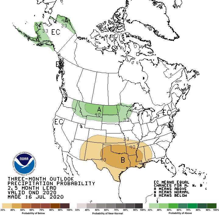
The NOAA OND 2020 precipitation forecast has the north getting above-average precipitation, with much of the Gulf Coast region receiving below-average precipitation. This means that resorts like Big Sky MT, Grand Targhee WY, and Jackson Hole WY, just to name a few. Fortunately, there aren’t many ski resorts in the region slotted to receive below-average precipitation, although parts of southern Colorado, such as Telluride, may receive lower amounts of early season snow.
If you’re doing some early season powder chasing in the resort or in the backcountry, head up north!
JFM 2021 forecast analysis:
Temperature:
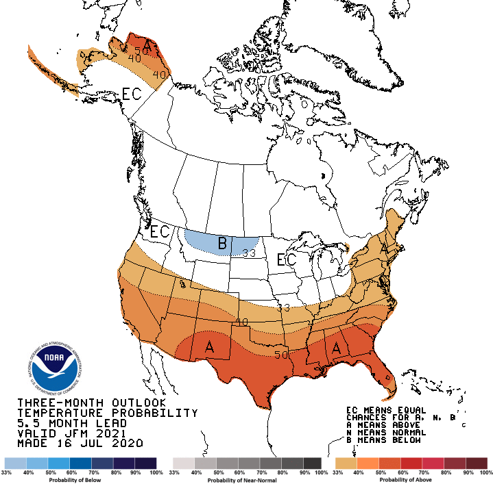
Again, it looks like early 2021 has some warm temperatures for most of the country.
In January, February, and March, now that the snowpack has gotten significantly deeper, there is no disadvantage to having cold temperatures, it only preserves the snow. Cold temperatures at this time of year may facet the upper layers of the snowpack, but not enough to create large enough temperature gradients to facet the entire snowpack and turn the snowpack “upside down.” (Again, I highly recommend watching this video. It just might save your life one day!)
Expect rain at lower elevations, and in places with shallow snowpack, to have lots of rocks and dirt exposed sooner in the season.
Precipitation:
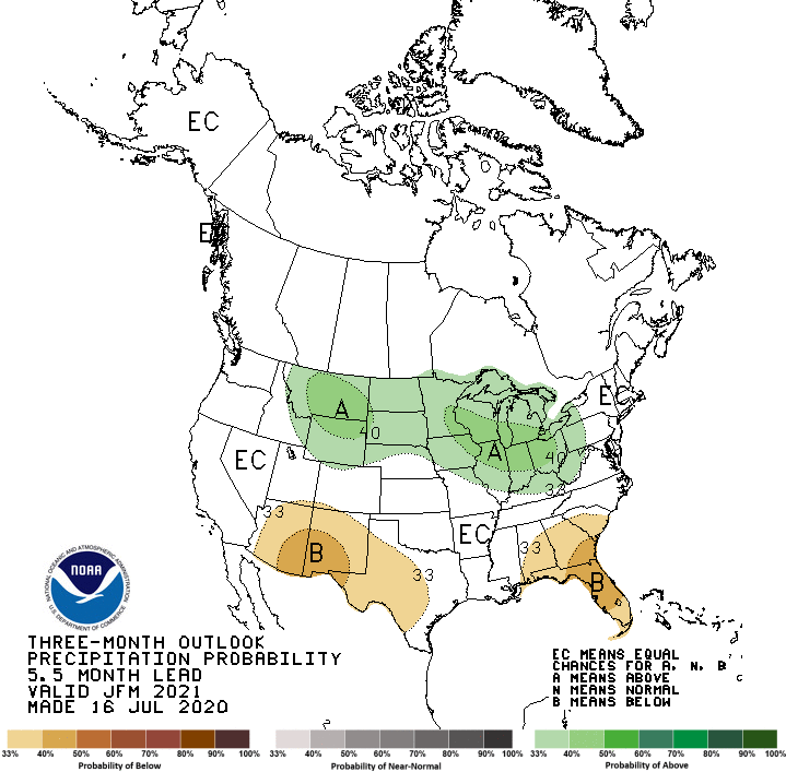
The JFM 2021 precipitation forecast continues to give the north favorable chances for a deep year. Northern ski states, Idaho, Montana, and Wyoming, continue to receive above-average precipitation.
Some areas in southern New England are also favored to have above-average precipitation.
The early season dryness in southern Colorado seems to have disappeared. Coloradans should expect a season with just barely below average snowfall.
TL;DR
According to these forecasts, the best skiing this season should be up north, in Montana, Idaho, and Wyoming. Southern Colorado is expected to have a dry start, but will then stabilize and receive average precipitation in late winter and early spring.
Most of the US will see above-average temperatures, which may mean rain at lower elevations. This above-average temperature may also help problematic avalanche conditions from forming early in the season.
Areas that are not favored for above or below average conditions could swing either way. With the La Niña pattern favored for the upcoming season, watch out for the PNW for a deep year.
These forecasts are generally inaccurate since it is too early to have a completely clear idea of what this winter will hold, but they can provide us with some pretty useful information about the general trends that the winter may follow.