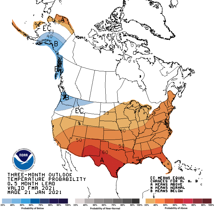
NOAA’s Climate Prediction Center issued its latest three-month seasonal outlook extending from February through April.
Temperatures are favored to be above-normal across the southern three-quarters of the country and northern Alaska, with an area of below-normal temperatures favored for the Pacific Northwest and southern Alaska.
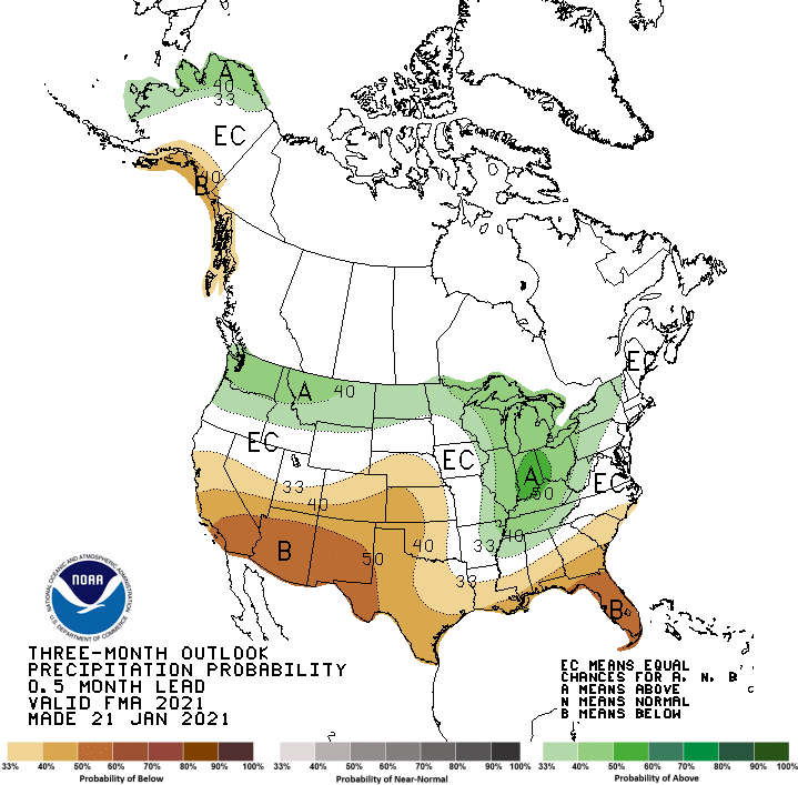
Areas of above-normal precipitation are most likely across the northern tier of the U.S. and extending down into the Lower Mississippi and Tennessee Valleys and northern Alaska. Below-normal precipitation is favored in southern Alaska and across the southern tier of the U.S., with the areas of greatest likelihood in the Southwest, Southern Rockies, parts of the Southern Plains, and over Florida.
TEMPERATURE
The temperature outlook for FMA 2021 reflects current model guidance, blended with likely impacts of La Nina and trends . The favoring of below normal temperatures across portions of mainland Alaska, the Alaska Panhandle, and the Pacific Northwest reflect La Nina conditions. The outlook is slightly warmer than last month’s outlook but colder than the recent model guidance for this region. The FMA outlook for the Northern Great Plains is warmer than last month’s lead 2 outlook, reflecting the ongoing lack of snow cover and more recent model guidance, though probabilities are modest at best from North Dakota to Illinois. Odds for above normal temperatures were also increased across the Lower Mississippi, Gulf Coast, and Florida, reflecting recent model guidance and likely La Nina impacts. The outlooks for later spring and summer 2021 reflect recent model guidance and trends , with the lowest probabilities in the central portions of the CONUS where variances are highest, model skill lowest, and trends are small to negative. Outlooks for next autumn were unchanged, as the reasoning behind the outlooks has not changed for those periods, and trends are the most reliable tool. Some outlooks are calling for a second La Nina winter, which would not be unprecedented since 1950, and the outlooks for next winter are already aligned for that possibility.
PRECIPITATION
La Nina is the primary physical driver behind the subsequent FMA and MAM precipitation outlooks, so only minor adjustments were needed to the corresponding outlooks made last month. In MAM, the amplitude of La Nina and its associated precipitation impacts are expected to begin to decline. In AMJ 2021, below normal precipitation amounts are forecast to diminish in spatial coverage across the southern CONUS, and be centered over most of the southwestern quarter of the CONUS. After AMJ, with a predicted ENSO Neutral, trends are more highly factored, which favors below normal precipitation for portions of the Northern and Central Rockies during summer months, shifting southward during the winter. East of the Mississippi, summer and early autumn months have a wet trend. By next winter, Dec-Jan-Feb 2021-22, the only remaining signal is the trend for above normal precipitation over the Northern Plains.