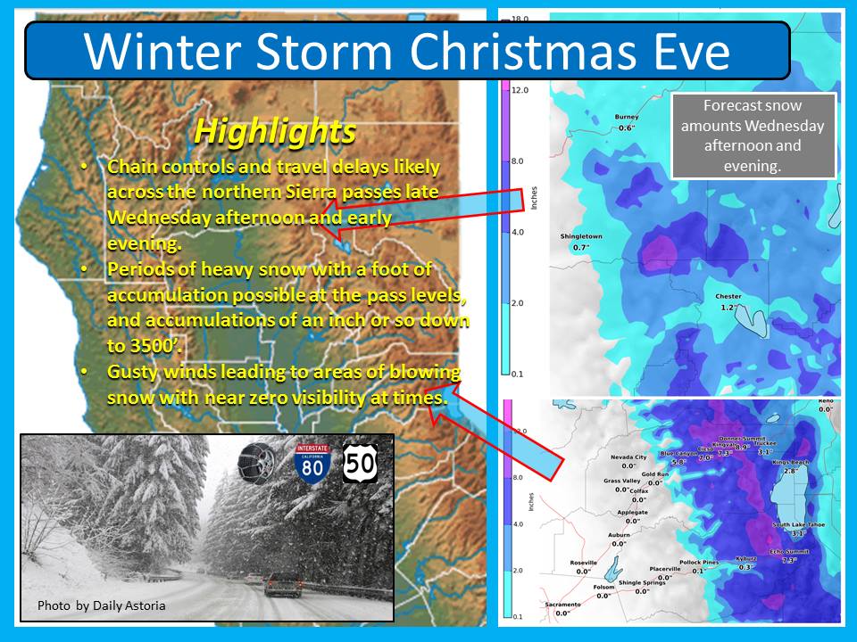
This morning, NOAA is forecasting a quick moving, cold storm that will hit Tahoe hard on Christmas Eve and hopefully leave behind up to a foot of snow. They’re talking about snow levels down to 3,500-feet! NOAA has issued a Winter Storm Watch for this Christmas Eve storm and they predict that it will show up on Wednesday afternoon and be gone by Christmas morning.
WINTER STORM WATCH:
URGENT - WINTER WEATHER MESSAGE
NATIONAL WEATHER SERVICE SACRAMENTO CA
330 AM PST TUE DEC 23 2014

...WINTER STORM TO AFFECT THE NORTHERN SIERRA CHRISTMAS EVE...

.A FAST MOVING WEATHER SYSTEM WILL IMPACT THE NORTHERN SIERRA AND
EXTREME SOUTHERN CASCADE REGION WEDNESDAY AFTERNOON AND EVENING. A
PERIOD OF HEAVY SNOW AND STRONG WINDS CAN BE EXPECTED LATE
WEDNESDAY AFTERNOON AND EARLY EVENING AS A STRONG COLD FRONT MOVES
THROUGH THE REGION LEADING TO TRAVEL DELAYS ACROSS THE MOUNTAIN
PASSES.

...WINTER STORM WATCH IN EFFECT FROM WEDNESDAY AFTERNOON THROUGH
WEDNESDAY EVENING ABOVE 4000 FEET...

THE NATIONAL WEATHER SERVICE IN SACRAMENTO HAS ISSUED A WINTER
STORM WATCH ABOVE 4000 FEET FOR WESTERN PLUMAS COUNTY...LASSEN
VOLCANIC NATIONAL PARK AND THE WEST SLOPES OF THE NORTHERN SIERRA
NEVADA...WHICH IS IN EFFECT FROM WEDNESDAY AFTERNOON THROUGH
WEDNESDAY EVENING.

* IMPACTS: TRAVEL DELAYS LIKELY DUE TO CHAIN REQUIREMENTS FOR
  HEAVY SNOW AND POOR VISIBILITY IN BLOWING SNOW.

* CONFIDENCE: MEDIUM.

* TIMING: WEDNESDAY AFTERNOON AND EVENING. THE HEAVIEST SNOW WILL
  LIKELY OCCUR LATE IN THE AFTERNOON INTO EARLY EVENING.

* LOCATIONS INCLUDE: CHESTER...QUINCY...LASSEN NATIONAL PARK...
  BLUE CANYON...DONNER PASS...ECHO SUMMIT...CARSON PASS.

* SNOW ACCUMULATIONS: 3 TO 6 INCHES WITH AROUND A FOOT OVER MT
  LASSEN AND ALONG THE CREST OF THE NORTHERN SIERRA.
Do Tahoe a Favor.. Next time you post about a storm coming don’t say anything about how many inches are expected. Talk about QPF’s from Gfs, Euro, Canadian ect. Then talk about possibilities of what could happen during the storm such as shadowing, not enough wind to carry over the crest or snow levels. Just for god’s sake don’t call it like you have the last few storms. The titles for your post and for the most part the content ended up all wrong…
Maddog, you’re right. But, the general public doesn’t understand QPFs. So, we simply report what NOAA forecasts. If it’s wrong, it’s NOAA not us. We don’t do forecasting. thanks.