March is often the snowiest month of the year, how many times have we heard ‘Miracle March’ has saved the season? With February almost at an end, here’s the NOAA’s outlook for the month ahead.
As we approach the month of March, the pattern across the greater North America region appears to be in the process of changing from the last few weeks. Week 2 dynamical model forecast guidance supports a change to anomalous ridging over the north-central Pacific with central North America mean trough shifted westward and deepening over portions of western North America including into western CONUS. Downstream of this, more amplified ridging and positive 500-hPa height departures are forecast for much of the southeast U.S. favoring a more southwesterly-westerly mean flow for the eastern half of the CONUS than in recent weeks.
The most recent Week 3-4 guidance from the CFS, ECMWF, and extended GEFS support a continuation of this change, in the mean, for approximately the first two weeks of March. March CFS forecasts as well as those from the majority of the NMME and Copernicus model suites also favor this pattern and associated anomalous temperature and precipitation patterns which are consistent with typical La Nina conditions in many ways during this point in the seasonal cycle.
Other factors to consider in addition to a review of the available dynamical model guidance across time scales, are the state and forecast evolution of the MJO, the AO, and the most recent anomalous snow cover.
The MJO has been active during January and February resulting in both constructive and destructive interference with La Nina impacting anomalous tropical rainfall, circulation, and other variables in the Pacific basin. Forecast information suggests that the MJO is likely to weaken or become less coherent entering March and is not strongly utilized in the March outlook due to this as well as indications that much of recent mid-latitude temperature and precipitation anomalies have most likely been driven by high latitude sub-seasonal variability.
Predictions in the short-term (next 10 days) indicate the phase of the AO (which has returned to near zero) to remain near zero or weakly positive in the mean as compared to the strongly negative phase of the last couple of months. The Sudden Stratospheric Warming (SSW) of early-mid January would continue to elevate odds for a negative AO phase into the month of March resulting in the continuation of potential cold air outbreaks into the mid-latitudes. There is high uncertainty, however, is whether the negative phase of the AO will return and persist and if so where troughing and so favored below-normal temperatures are most likely to develop at forecast lead times well into the month of March.
Finally, substantially below-normal snow cover and snow depth exist across parts of the northern Plains and upper Mississippi Valley. Although, early in the seasonal cycle, taken alone, this is likely to favor above-normal temperatures in these areas.
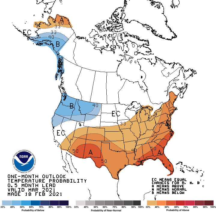
After consideration of the factors described above, the March temperature outlook favors monthly mean below-normal temperatures for a region stretching from south-central Alaska southeastward to include northern California, the Pacific Northwest, and the northern Rockies. This is strongly supported by dynamical model guidance across time scales and is consistent with La Nina conditions. Elevated probabilities for above-normal temperatures are depicted for parts of the north and west coast of Alaska based on negative sea ice and positive ocean surface temperature trends especially later in the month of March.
Dynamical model guidance and in some cases typical La Nina conditions and positive temperature trends favor above-normal temperatures for a region from the Southwest eastward to include the southern CONUS and northward to encompass the central Mississippi Valley, eastern Great Lakes, Ohio Valley, and eastern seaboard. Only slightly tilted odds of above-normal temperatures or Equal-Chances (EC) are depicted for the northern and central Plains, central and upper Mississippi Valley, and parts of the Ohio Valley, Great Lakes, and Tennessee Valley due to the uncertainty and conflicting indicators described above with respect to the phase of the AO, anomalous snow cover and snow depth and dynamical model guidance.
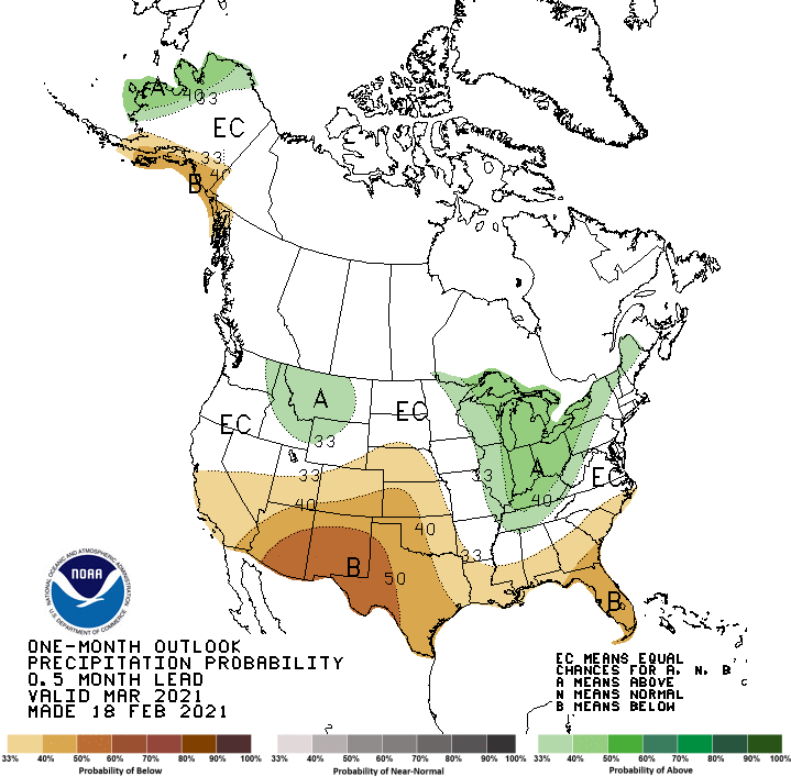
For precipitation, below-normal monthly total precipitation amounts are most likely for the southern tier of the CONUS with some expansion of this highlighted area to the central Great Plains, primarily based on dynamical model guidance which is consistent with La Nina typical impacts. For similar reasons, elevated odds for above-normal precipitation is forecast for a small region in the northern Rockies and for the Ohio Valley and Great Lakes region. For Alaska, elevated odds for above-normal precipitation is depicted for parts of the north and west coasts associated with anticipated more open and warmer waters in nearby areas as well as typical La Nina impacts. Below-normal precipitation is most likely for the south-central coast and far northern Alaska Panhandle.