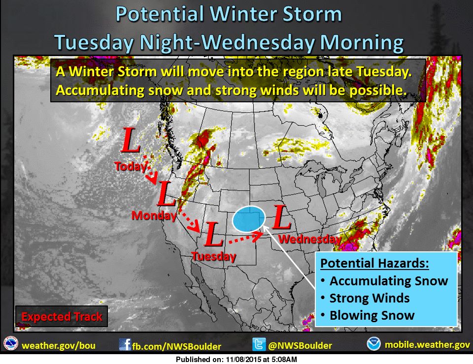
NOAA is forecasting ‘potent winter storm” to hit Colorado this Tuesday.
A POTENT STORM SYSTEM WILL BEGIN IMPACTING THE CENTRAL ROCKIES
DURING THE DAY TUESDAY. - NOAA Denver, CO
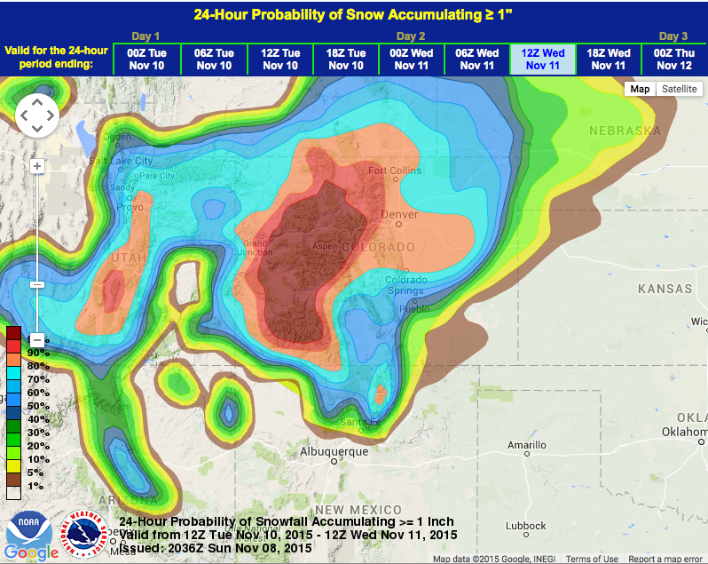
NOAA is calling for significant snowfall totals from this storm on Tuesday.
THE STORM WILL BRING A GOOD CHANCE OF ACCUMULATING SNOW TO THE
MOUNTAINS TUESDAY AND TUESDAY NIGHT. - NOAA Denver, CO
“A storm system off the Pacific Northwest will move into the region by late Tuesday. Rain and Snow will develop late in the day, likely changing to all snow with strong winds developing on the back side of the storm system Tuesday night into early Wednesday. If the storm develops as expected, blizzard conditions will be possible on the eastern plains of Colorado. Until then, look for dry and mild conditions to prevail today and Monday. Temperatures will continue their warming trend under sunny skies today.” – NOAA Denver, CO
Loveland, Arapahoe Basin, and Keystone are open daily in Colorado right now. Wolf Creek will open daily on Wednesday. We’re gonna have some powder days in Colorado this week.
HAZARDOUS WEATHER STATEMENT for COLORADO:
HAZARDOUS WEATHER OUTLOOK
NATIONAL WEATHER SERVICE DENVER/BOULDER CO
1053 AM MST SUN NOV 8 2015

THIS HAZARDOUS WEATHER OUTLOOK IS FOR NORTHEAST AND NORTH CENTRAL
COLORADO.

.DAY ONE...TODAY AND TONIGHT

SUNNY SKIES UNDER A STRONG RIDGE OF HIGH PRESSURE WILL CONTINUE
THE WARMING TREND TODAY.

.DAYS TWO THROUGH SEVEN...MONDAY THROUGH SATURDAY

DRY AND MILD CONDITIONS WILL CONTINUE MONDAY AND MONDAY NIGHT
WITH INCREASING WINDS OVER THE HIGH COUNTRY MONDAY AFTERNOON.

A POTENT STORM SYSTEM WILL BEGIN IMPACTING THE CENTRAL ROCKIES
DURING THE DAY TUESDAY. THIS STORM WILL MOVE ON TO THE GREAT
PLAINS BY WEDNESDAY AFTERNOON WITH NORTHWEST FLOW ALOFT CONTINUING
OVER COLORADO IN ITS WAKE.

THE STORM WILL BRING A GOOD CHANCE OF ACCUMULATING SNOW TO THE
MOUNTAINS TUESDAY AND TUESDAY NIGHT...AND THEN TO THE PLAINS
TUESDAY NIGHT AND WEDNESDAY MORNING. SCATTERED SNOW SHOWERS WILL
LINGER IN THE MOUNTAINS INTO THURSDAY. GUSTY WINDS ARE ALSO
EXPECTED ON THE PLAINS TUESDAY NIGHT AND WEDNESDAY MORNING WHICH
WILL PRODUCE AREAS OF BLOWING SNOW. STAY TUNED TO LOCAL MEDIA
OUTLETS AND NATIONAL WEATHER SERVICE FORECASTS FOR THE LATEST
INFORMATION REGARDING THIS DEVELOPING WINTER STORM.