The National Weather Service has issued a Winter Weather Advisory for Colorado. It’s in effect from 6:00pm this evening through 6:00pm Saturday evening. High winds and heavy snow is forecasted to impact the area throughout this time. The heaviest snowfall will occur tonight.
Colorado:
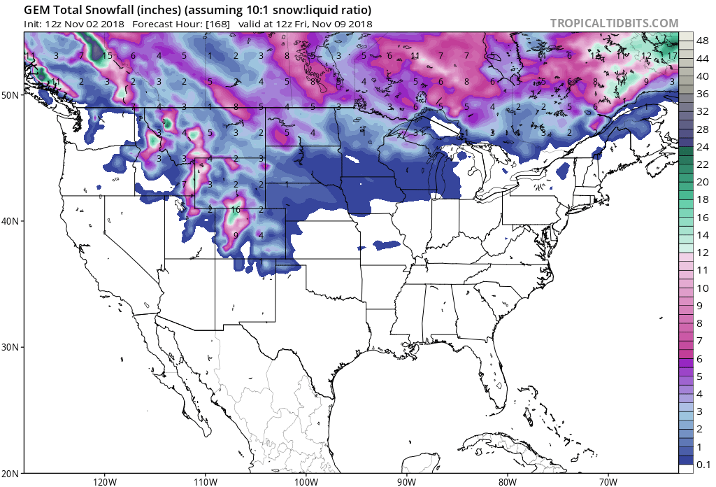
5-12″ of Snow Tonight – Saturday Night
This storm should set Copper Mountain, CO well for their opening day on Friday, November 16th, 2018.
Snow levels are forecasted to start out around 8,000ft, but they are forecasted to drop down to 6,000ft.
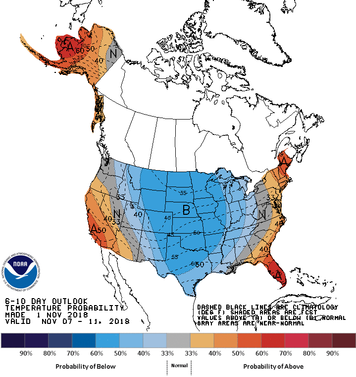
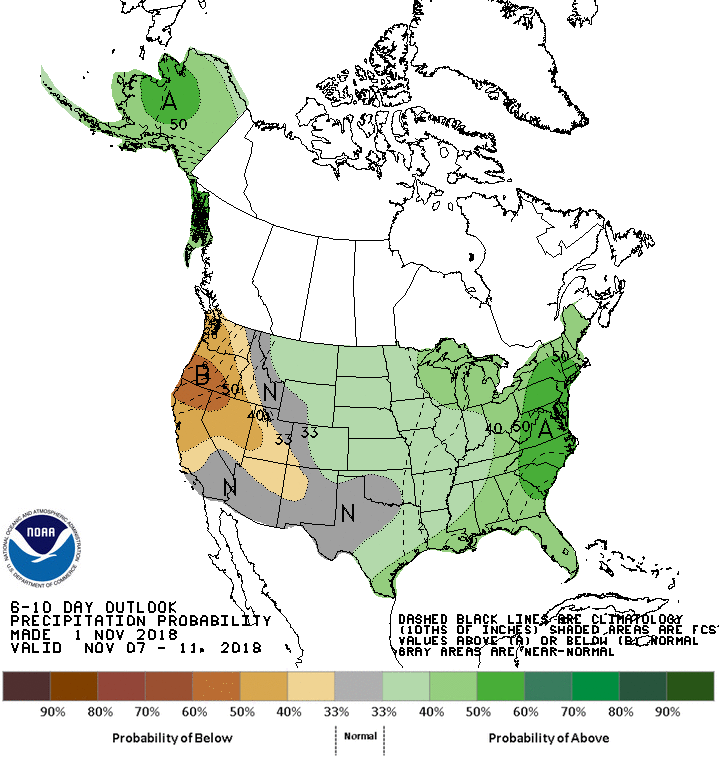
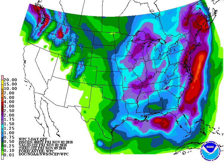
The 6-10 day outlook calls for below average temperatures and above average precipitation in Colorado.
Additional Info:
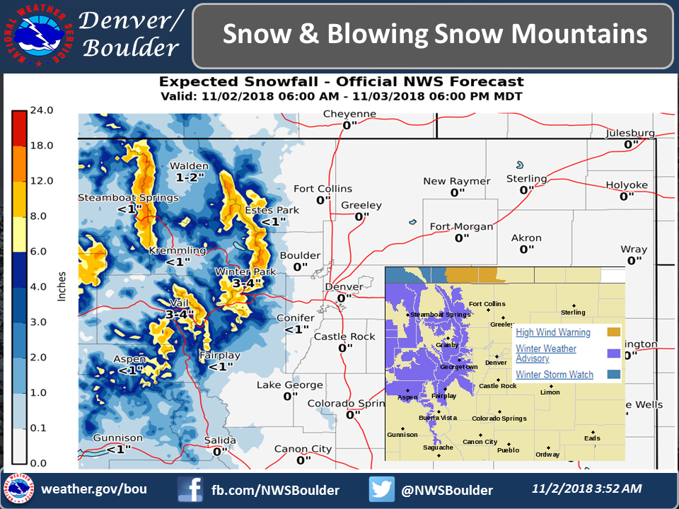
Colorado: 5-12″ of Snow Tonight – Saturday Night
* Total snow accumulations of 5 to 12 inches expected.
  Winds gusting up to 60 mph over the higher passes.
- NOAA Denver, CO
Winter Weather Advisory:
URGENT - WINTER WEATHER MESSAGE
National Weather Service Denver CO
1040 AM MDT Fri Nov 2 2018

...PERIODS OF SNOW AND BLOWING SNOW HEADED FOR THE MOUNTAINS OVER
THE NEXT FEW DAYS...

.A powerful and moist Pacific jet stream will bring several waves
of snow and blowing snow to the mountains. Light snow, mixed with
drizzle and even a little freezing drizzle this afternoon will
give way to heavier snow this evening. The heavier snow is first
expected to develop in the Rabbit Ears Pass and Rocky Mountain
National Park area toward 6 PM, and then shift to the I-70
Corridor by 8-10 PM. Snow will continue overnight, before slowly
decreasing through the day on Saturday. Strong winds and blowing
snow will accompany this system, creating hazardous travel
conditions in the Colorado high country, including the I-70
Corridor from Georgetown through Vail Pass.

Travel conditions may improve for late Saturday into Sunday
morning, before the next storm arrives Sunday afternoon and
continues through Monday with more snow and blowing snow
expected.

Rabbit Ears Pass-
Rocky Mountain National Park and the Medicine Bow Range-
The Mountains of Summit County, the Mosquito Range, and the
Indian Peaks-
Including the cities of East Slopes Park and Northern Gore
Ranges, Gore Pass, Rabbit Ears Pass, Cameron Pass,
Laramie and Medicine Bow Mountains, Rabbit Ears Range,
Rocky Mountain National Park, Willow Creek Pass, Berthoud Pass,
Breckenridge, East Slopes Mosquito Range,
East Slopes Southern Gore Range, Eisenhower Tunnel, Indian Peaks,
Kenosha Mountains, Mount Evans, Williams Fork Mountains,
and Winter Park

...WINTER WEATHER ADVISORY REMAINS IN EFFECT FROM 6 PM THIS
EVENING TO 6 PM MDT SATURDAY...

* WHAT...Snow expected, with the heaviest snow tonight. Total snow
  accumulations of 5 to 12 inches expected. Winds gusting up to
  60 mph over the higher passes.

* WHERE...Rabbit Ears Pass, Rocky Mountain National Park and the
  Medicine Bow Range and The Mountains of Summit County, the
  Mosquito Range, and the Indian Peaks.

* WHEN...From 6 PM Friday to 6 PM MDT Saturday.

* ADDITIONAL DETAILS...Travel could become very difficult as the
  heavier snow develops this evening. Areas of blowing snow will
  significantly reduce visibility.