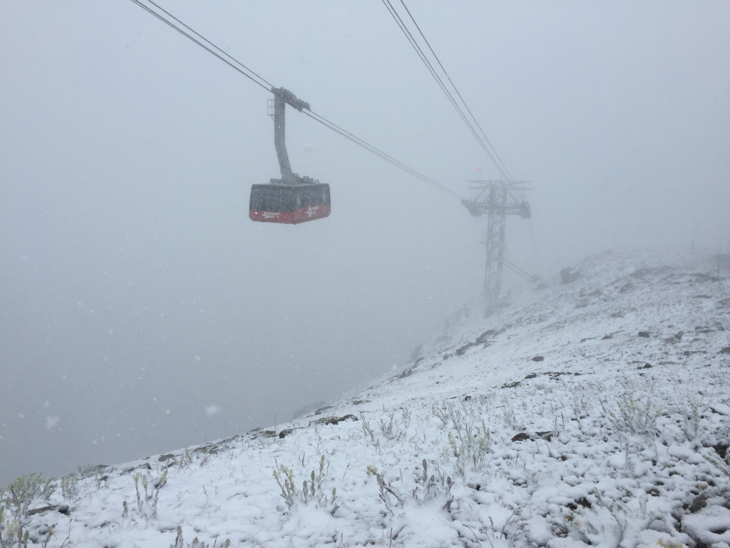
NOAA is forecasting snow all over the Rocky Mountains this week.
There’s talk of significant, accumulating snow…
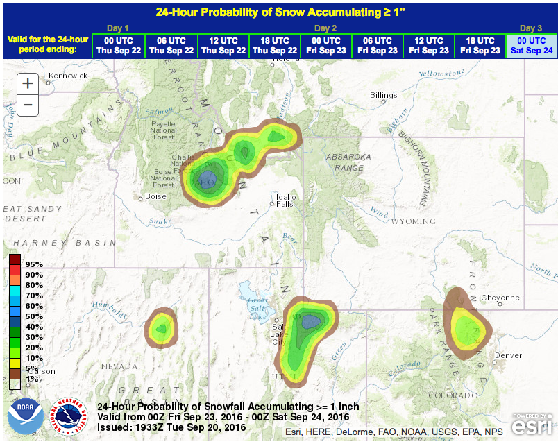
“As cooler air filters in Thursday, we expect the high elevations to begin seeing accumulating snow above 9000 ft with travel hazards expected on these high mountain passes.” – NOAA Billings, MT yesterday
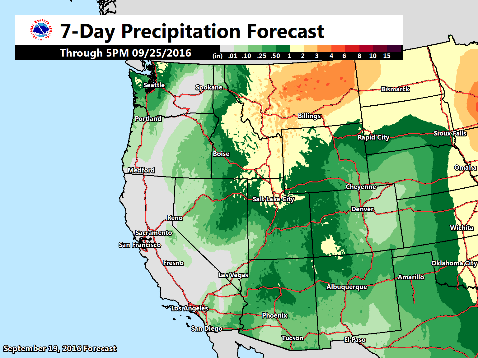
Snow is forecast in Colorado, Utah, Wyoming, Montana, and Nevada.
Even California is forecast to get snow this week and even has a Special Weather Statement issued…
UTAH:
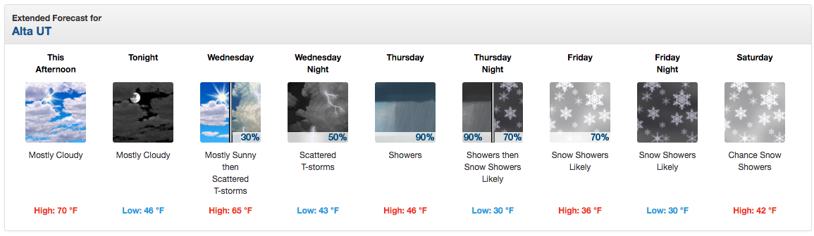

If the current guidance holds true, this should be a widespread
precip event with snow levels falling to 7000 feet and
significantly cooler temps for the entire CWA. - NOAA SLC, UT today
COLORADO:
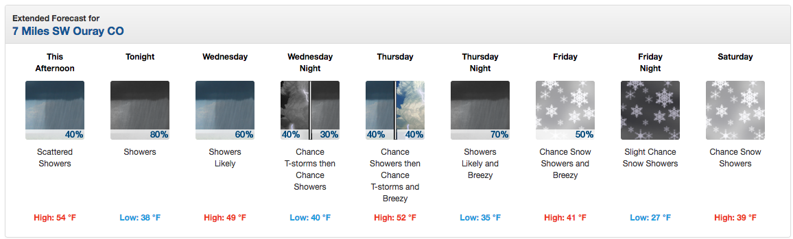
“Showers and thunderstorms will be returning over the next few days as moisture from Hurricane Paine in the eastern Pacific Ocean lifts north. The best chance for seeing rain will be over the Four Corners and over the San Juan Mountains in southwest Colorado Tuesday afternoon and evening. Some snow is even possible for elevations above 11,000 ft.
If you are venturing into the Colorado High Country over the next few days, be prepared for wet weather as the moisture spreads north. A strong cold front is also expected to pass through by late in the week. This will drive snow levels down to as low as 8000 feet by Friday. The question is, will we have enough moisture left to result in any accumulation??? Confidence is high that we will see unsettled weather off and on through the end of the week, so keep checking back for the latest weather information.” – NOAA Grand Junction, CO yesterday
[iframe id=”https://www.facebook.com/plugins/video.php?href=https%3A%2F%2Fwww.facebook.com%2FNWSGrandJunction%2Fvideos%2F1401967189814901%2F&show_text=0&width=400″]
UNSETTLED WEATHER CONTINUES WEDNESDAY AS THE IMPULSE MOVES OUT OF
THE REGION. FROM THURSDAY ONWARDS...A DEEP CLOSED LOW WITH A
STRONG CLOSED LOW WILL BRING RAIN...THUNDERSTORMS...GUSTY
WINDS. ONCE THE FRONT PUSHES THROUGH...TEMPERATURES WILL DROP
CONSIDERABLY ALLOWING SOME SNOW TO FALL AT THE HIGHEST ELEVATIONS.
- NOAA Grand Junction, CO today
IDAHO:
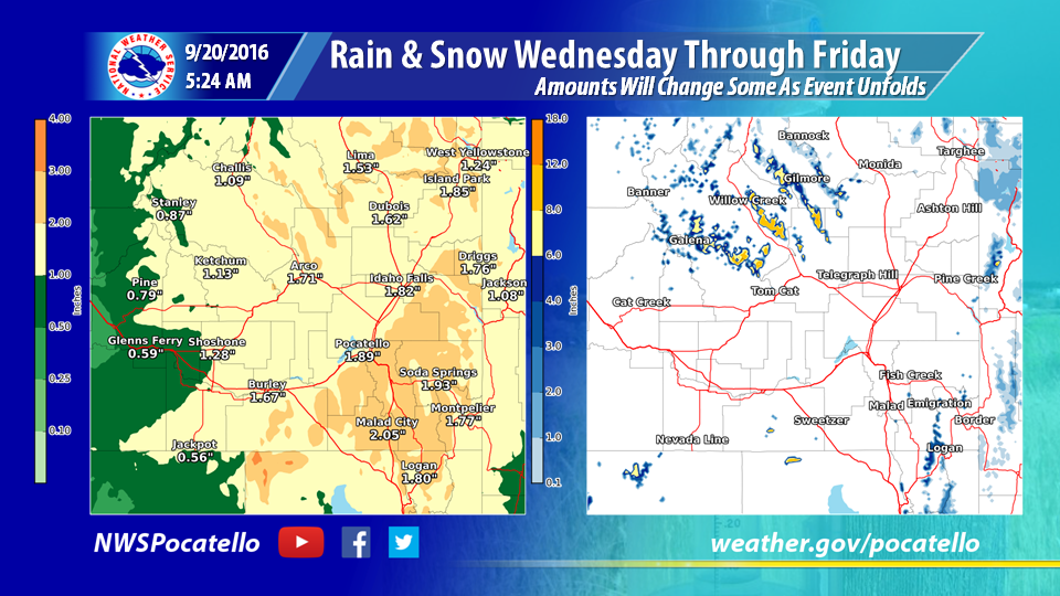
“624am 9/20: WET is all you need to for the weather after today. We are expecting these amounts to shift/fluctuate as this event unfolds. If you are going to be out in the backcountry for any length of time, be ready for colder weather and snow.” – NOAA Pocatello, ID today
WYOMING:
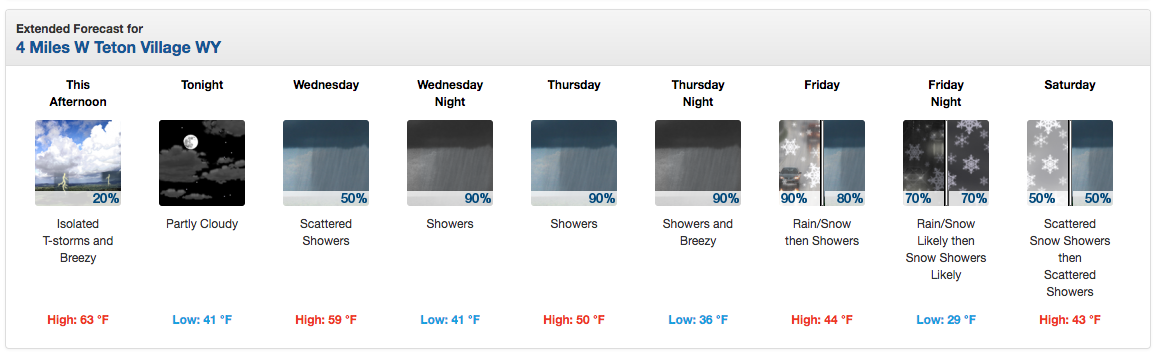
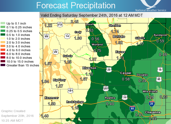
“Forecast still looking wetter and cooler to end the work week, particularly Thursday & Friday. This graphic is a forecast of the precipitation expected from 6am Wednesday through Friday evening. Best chance for wet weather will be Thursday and Friday.” – NOAA Riverton, WY today
As for the chance of snow, the
origin of the air is Pacific so it is not tremendously cold. The
mountain tops will likely be seeing snow by Thursday night and it
could get down close to pass level by early Friday morning.
Cooler temperatures will accompany this system, resulting in mountain snowfalls Friday, with some light snowfall possible over the western basins Friday night. - NOAA Riverton, WY today
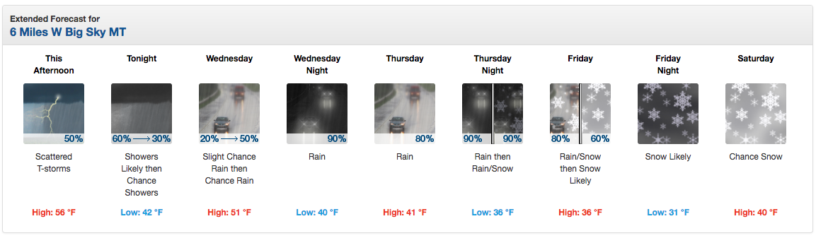
MONTANA:


“We know there are still quite a few who venture into the backcountry during these early fall days, so if you or anyone you know is heading into the mountains this Wednesday through Friday: a very cold, wet storm system will bring snow levels to about 6000 feet along the Continental Divide, and will be combined with gusty winds. The threat for hypothermia, low visibility, and overall ugly and harsh conditions will be present. We’ll continue to update everyone through the week on this system!” – NOAA Missoula, MT yesterday
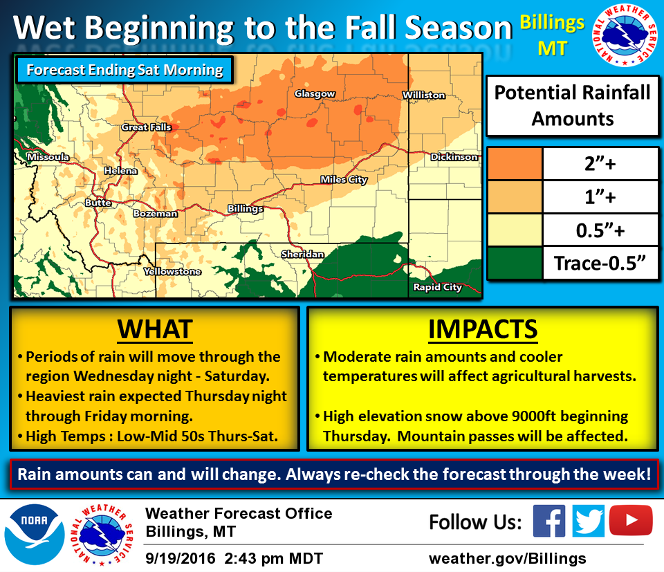
“The first day of Fall will bring quite a change to our weather as rain showers begin to move in Wednesday evening. Expect temperatures to drop into the 50s for the latter part of the week. As cooler air filters in Thursday, we expect the high elevations to begin seeing accumulating snow above 9000 ft with travel hazards expected on these high mountain passes. The heaviest rain showers will affect regions north and west of Billings overnight Thursday into Friday morning. The moderate rainfall amounts will also have some impacts on agricultural harvests ongoing around the region. These rainfall amounts will change so make sure you check the forecast everyday! Get your umbrellas ready!” – NOAA Billings, MT yesterday