
Mother Nature decided to welcome us all to the first day of Fall with snow.
NOAA is forecasting snow in Utah, Wyoming, Idaho, Colorado, Nevada, & Montana the next 3 days.
NOAA has issued a Hazardous Weather Outlook for the Wasatch Mountains in Utah where 9-15″ of snow are forecast today – Friday.
NOAA is forecasting 11-20″ of snowfall in southwest Montana…
Snow already fell in Oregon, Nevada, and California today.
UTAH:


“A soggy day over much of Utah slams us into fall, as an approaching cold front brings cold temperatures and high-elevation snow by tomorrow.” – NOAA SLC, UT today


WYOMING:

Up 6-12″ of snow forecast in the Wind River Range of Wyoming through Friday.
FRIDAY AND FRIDAY NIGHT...SHOWERS WITH LOCALLY HEAVY RAIN
POSSIBLE...MAINLY WEST OF THE DIVIDE. SNOW LEVELS POSSIBLE
DROPPING TO PASS LEVEL. - NOAA Riverton, WY today

SATURDAY...SNOW POSSIBLE OVER THE HIGHER ELEVATIONS OF THE
NORTHERN MOUNTAINS...ESPECIALLY THE BIGHORNS.


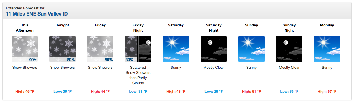
IDAHO:

Snow levels will fall to around 7500 to 8000 feet
by Friday. Any locations above this level could see several inches
of snow. - NOAA Boise, ID today

MONTANA:

“A broad weather system will spread precipitation across the region for the next few days (through Saturday). Current rainfall total forecasts range from just a trace in extreme western Montana to over 2 inches in north central Montana.” – NOAA Billings, MT yesterday

“One note, this is not a very cold storm system so only the highest elevations should see snow but that includes Beartooth Pass.” – NOAA Billings, MT yesterday


COLORADO:

NOAA is forecasting snow all over Colorado on Sunday.
AN INCH OR
TWO OF SNOW MAY ALSO BE POSSIBLE ALONG THE CONTINENTAL DIVIDE
ABOVE 10000 FEET BY MORNING. - NOAA Denver, CO today

NEVADA:


OREGON:


CALIFORNIA:

[iframe id=”https://www.facebook.com/plugins/video.php?href=https%3A%2F%2Fwww.facebook.com%2Fborealmtn%2Fvideos%2F10154435107966093%2F&show_text=0&width=560″]
video of snowfall at Boreal, CA today


NOAA: Dusting of Snow for Lake Tahoe & Mammoth Today | Snow Down to 7,000′
Snow All Over Lake Tahoe, CA/NV Today | Photo Tour:
***
HAZARDOUS WEATHER OUTLOOK in UTAH:
HAZARDOUS WEATHER OUTLOOK
NATIONAL WEATHER SERVICE SALT LAKE CITY UT
308 AM MDT THU SEP 22 2016

CACHE VALLEY/UTAH PORTION-NORTHERN WASATCH FRONT-
SALT LAKE AND TOOELE VALLEYS-SOUTHERN WASATCH FRONT-
GREAT SALT LAKE DESERT AND MOUNTAINS-WASATCH MOUNTAIN VALLEYS-
WASATCH MOUNTAINS I-80 NORTH-WASATCH MOUNTAINS SOUTH OF I-80-
WESTERN UINTA MOUNTAINS-WASATCH PLATEAU/BOOK CLIFFS-
WESTERN UINTA BASIN-CASTLE COUNTRY-SAN RAFAEL SWELL-
SANPETE/SEVIER VALLEYS-WEST CENTRAL UTAH-SOUTHWEST UTAH-
UTAHS DIXIE AND ZION NATIONAL PARK-SOUTH CENTRAL UTAH-
GLEN CANYON RECREATION AREA/LAKE POWELL-CENTRAL MOUNTAINS-
SOUTHERN MOUNTAINS-SOUTHWEST WYOMING-

THIS HAZARDOUS WEATHER OUTLOOK IS FOR THE WESTERN TWO THIRDS OF
UTAH AND SOUTHWEST WYOMING.

.DAY ONE...TODAY AND TONIGHT

WIDESPREAD SHOWERS AND THUNDERSTORMS MAY BE HEAVY AT TIMES LEADING
TO THE POTENTIAL FOR FLASH FLOODING FOR PRONE AREAS OF SOUTHERN
UTAH ALONG WITH URBAN FLOOD ISSUES ELSEWHERE. STRONG GUSTY WINDS
WILL DEVELOP TODAY...IMPACTING MUCH OF WESTERN AND SOUTHERN UTAH.

.DAYS TWO THROUGH SEVEN...FRIDAY THROUGH WEDNESDAY

THE CORE OF THE COLD FALL STORM WILL BE OVERHEAD FRIDAY BEFORE
SHIFTING EAST DURING THE WEEKEND. SNOW LEVELS WILL FALL TO NEAR
SEVEN THOUSAND FEET AT TIMES FRIDAY AND SATURDAY. GUSTY WINDS WILL
ALSO REMAIN POSSIBLE NEAR CANYONS ACROSS SOUTHERN UTAH SATURDAY
NIGHT AND SUNDAY MORNING.

FLOODING IS POSSIBLE DUE TO WIDESPREAD HEAVY PRECIPITATION
THURSDAY AND FRIDAY.

A HARD FREEZE IS POSSIBLE ACROSS THE WASTACH BACK...SANPETE AND
SEVIER VALLEYS...AND NEAR CEDAR CITY SUNDAY MORNING.