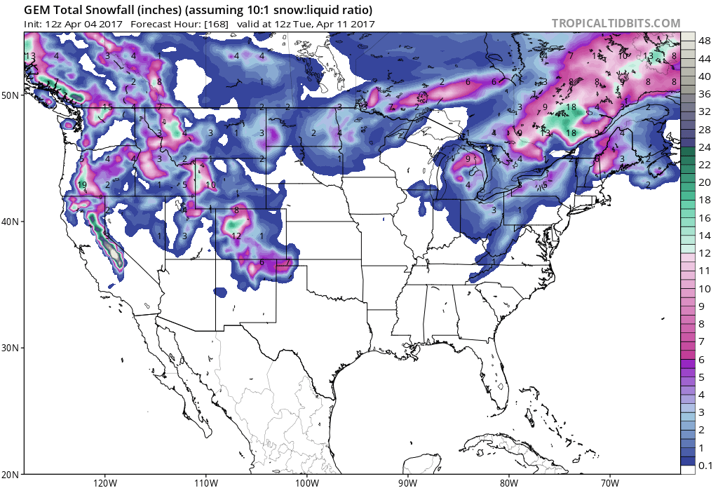
This Atmospheric River Event that is expected to hit California Thursday-Sunday and drop up to 4 FEET of snow, may be the BIGGEST APRIL STORM to hit Tahoe in 13 years.
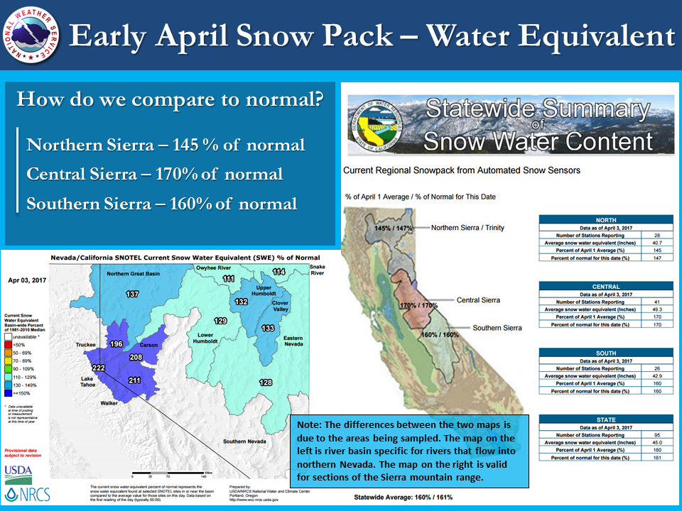
"...the last time Tahoe City saw a 2-day total of 2"+ liquid precipitation in April was back in 2003!"
- NOAA, Today

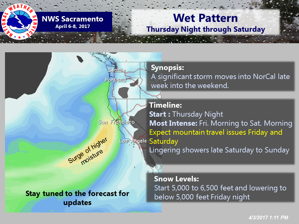
The heaviest precipitation is expected to fall Friday.
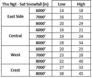
Thursday-Sunday precipitation totals are forecast to be 2-5″ (which would translate to around 20-50+” of snow where it’s all snow).
Snow Levels are forecast to start around 5,000-6,000′ on Friday before dropping to 4,000-5,500′ on Friday night and Saturday and even lower on Sunday. Some snow is even expected to fall in the valley floors.
"Confidence is high for heavy rain and snow late
Thursday night through Saturday, but lower for snow levels and
subsequently snow totals and flood potential."
- NOAA Today
Our friend, Bryan Allegretto from OpenSnow.com, is calling for 34″ of snow for Squaw from Thursday-Sunday.
NOAA FORECAST DISCUSSION TODAY:
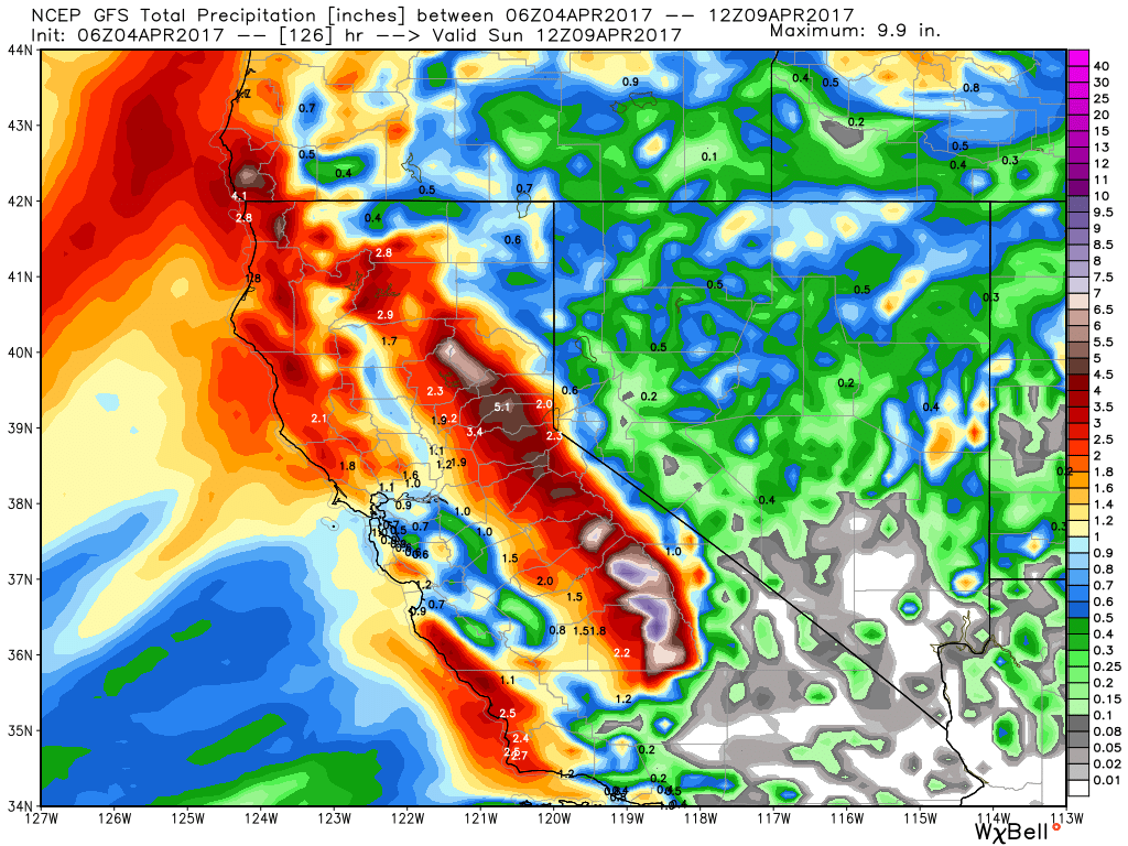
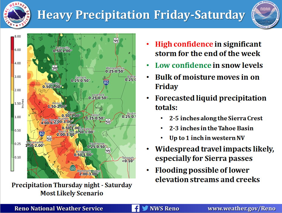
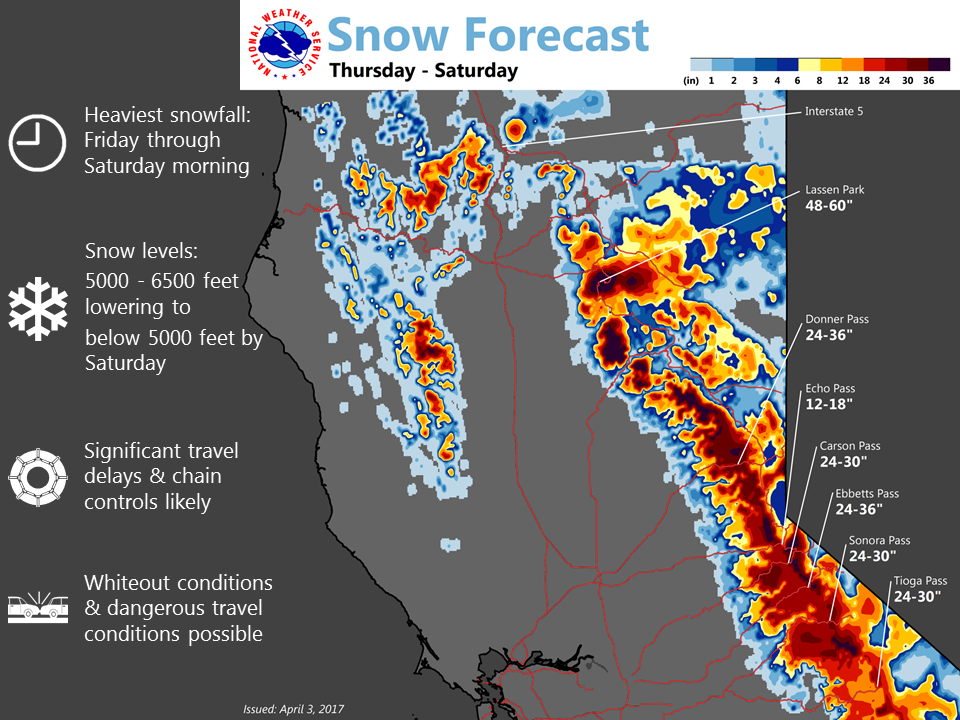
In what has seemed to be "the winter of atmospheric rivers", we have
yet another storm headed our way this weekend. Integrated Water
Vapor Transport detection ensemble tools would categorize this as a
solid moderate atmospheric river event, but factoring in the time of
year, this is a strong storm for April. For example, the last time
Tahoe City saw a 2-day total of 2"+ liquid precipitation in April
was back in 2003! Confidence is high for heavy rain and snow late
Thursday night through Saturday, but lower for snow levels and
subsequently snow totals and flood potential.

Here are the highlights with regards to next weekend:

PRECIPITATION: The initial push of moisture will move into the west
late Thursday night going into early Friday morning with the
heaviest precipitation rates likely to be Friday for much of
northeast California, the Sierra, and western Nevada. There will be
a secondary maximum in rates late Friday night into Saturday
morning, but the focus for this piece looks a bit farther south,
from the central Sierra southward. Areas of steady rain and snow
will taper to showers Saturday afternoon into evening, with the
most recent forecast simulations showing little additional
precipitation for Sunday. Liquid precipitation totals indicate
chances for 2-5 inches along the Sierra crest with 1-3 inches in
the Tahoe Basin, eastern Sierra foothills, and northeast
California. 0.5-1 inch is possible along the Sierra Front with
lesser amounts into west central Nevada.

SNOW LEVELS: After several days of seeing snow levels trending
downward, a shortwave has put a literal kink in the forecast as it
digs south and the flow turns from westerly to southwesterly,
allowing warmer air to once again filter into the region Friday
afternoon and evening. Snow levels are likely to lower quickly
Friday morning in the heavy precipitation, around 6000 feet near the
Oregon border down to 7500 feet in the southern Sierra. Snow levels
may jump 500-1000 feet during the brief period of warmer air working
into the region, then quickly fall by Saturday morning as a cold
front moves through the area. Snow levels will be low enough
Saturday afternoon and evening for a mix of rain and snow down to
all valley floors in Western Nevada. The biggest potential
variation in snow totals will be in the 6000-7500 foot range where
there is less certainty in the heavier rounds of precipitation
falling as rain or snow.
While this storm is nothing like the huge AR events we saw in
January and February, it has the potential to be a significant snow
event for the high Sierra, with several feet of snow likely.