The first snow of the season in Tahoe is on track to hit tomorrow, which is impressive considering NOAA forecasted this thing a week out. The weekend in Tahoe will be windy, rainy, cold, and a bit snowy.
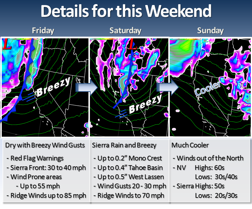
“The images above are model precipitation and pressure showing the relative position of the cold front that will progress through Northern California and Western Nevada this weekend. A strong jet moves over the region on Friday preceding the cold front bringing breezy conditions to the Sierra, Sierra front and Nevada interior. Combined with dry air in place, critical fire weather conditions will occur Friday and Friday night. Red Flag Warnings are in effect from the Sierra crest to central Nevada during the day on Friday and continue for areas south of I-80 until early Saturday morning. Also, Lake Wind Advisories will be in effect for Lake Tahoe and Pyramid Lake on Friday; Lake Tahoe’s advisory will continue through Saturday evening.
The cold front moves through Northern California and Western Nevada on Saturday. The best chances of rain will be along the Sierra crest and in western Lassen County. These locations could receive up to 0.5 inches of precipitation. With snow levels 7500- 8500 feet, the higher peaks of the Sierra could get a dusting of snow with some falling over Highway 441 on Mount Rose and along the Carson Pass. Some locations in western Nevada could also receive some precipitation, but these locations will be largely shadowed receiving generally less than 0.1 inches of rain. Winds will remain breezy through the day on Saturday, but less than Friday.
Cold air pushes across the western US on Sunday. With northerly flow, temperatures will average 10-20 degrees lower than this past week. Generally, high temperatures will be in the mid to upper 60s in western Nevada valleys and mid to upper 50s in the Sierra. Morning lows will range much cooler as well with upper 20s to low 30s in the Sierra and mid 30s to low 40s in western Nevada. Frost will be likely Sunday morning as temperatures bottom out and may damage any exposed plants. For complete details, please, read our Area Forecast Discussion: http://www.wrh.noaa.gov/total_forecast/getprod.php?wfo=rev&pil=AFD&sid=REV&version=0.” – NOAA
I’ll take it, not much, but I’ll take it.