.A VIGOROUS LATE WINTER STORM SYSTEM WILL BRING RAIN CHANGING TO
SNOW THIS EVENING WITH PERIODS OF MODERATE TO HEAVY SNOW AT TIMES
THROUGH TUESDAY NIGHT. - NOAA Riverton, WY today
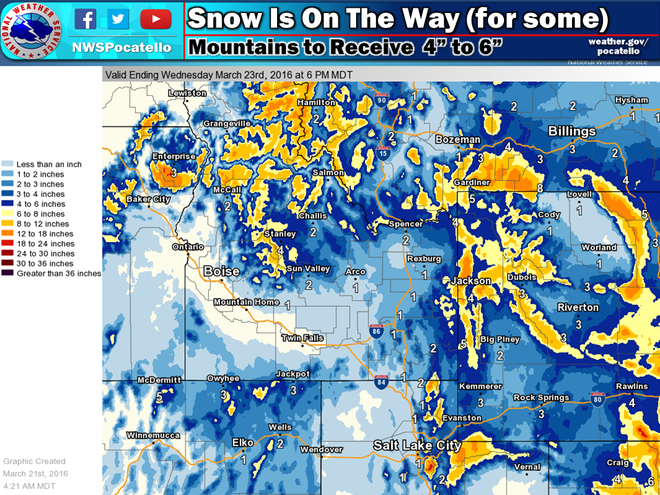
NOAA has issued a Winter Weather Advisory for the Teton Range in Wyoming that is calling for 4-10″ of snowfall today and tomorrow. They’re also saying it’s going to be a “snow filled week.” We like the sound of that.
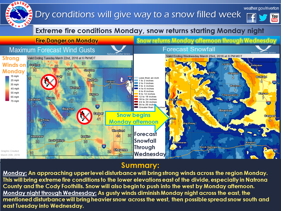
“Dry conditions to give way to a snow filled week. Windy and dry conditions will bring elevated to extreme fire danger to the lower elevations of areas east of the divide Monday. An upper level disturbance will then bring snow across the west Monday afternoon, and increase in intensity Monday night into Tuesday. Accumulating snow could then spread across the south and east Tuesday through Wednesday.” – NOAA Riverton, WY yesterday
4-10″ of snow is forecast in the Tetons tonight and tomorrow.
* SNOWFALL AMOUNTS...6 TO 12 INCHES WITH ISOLATED HIGHER AMOUNTS
  RANGING TO 14 INCHES. - NOAA Riverton, WY today
Grand Targhee =
- 348″ snowfall this season
- 102″ snowpack
Jackson Hole =
- 292-374″ snowfall this season
- 77-97″ snowpack
WINTER WEATHER ADVISORY for WYOMING:
URGENT - WINTER WEATHER MESSAGE
NATIONAL WEATHER SERVICE RIVERTON WY
1256 AM MDT MON MAR 21 2016

...SIGNIFICANT SNOW ACROSS THE WESTERN MOUNTAINS AND VALLEYS
BEGINNING TONIGHT AND LASTING THROUGH TUESDAY NIGHT...

.A VIGOROUS LATE WINTER STORM SYSTEM WILL BRING RAIN CHANGING TO
SNOW THIS EVENING WITH PERIODS OF MODERATE TO HEAVY SNOW AT TIMES
THROUGH TUESDAY NIGHT.

TETON AND GROS VENTRE MOUNTAINS

...WINTER WEATHER ADVISORY IN EFFECT FROM 6 PM THIS EVENING TO
6 AM MDT WEDNESDAY...

THE NATIONAL WEATHER SERVICE IN RIVERTON HAS ISSUED A WINTER
WEATHER ADVISORY FOR SNOW...WHICH IS IN EFFECT FROM 6 PM THIS
EVENING TO 6 AM MDT WEDNESDAY.

* TIMING...ISOLATED TO SCATTERED SNOW SHOWERS THIS AFTERNOON WILL
  BECOME MORE WIDESPREAD THIS EVENING...AS SNOW LEVELS DROP FROM
  AROUND 8000 FEET TO THE VALLEY FLOORS THROUGH THE EVENING. AN
  ISOLATED THUNDERSTORM WILL NOT BE OUT OF THE QUESTION. SNOW WILL
  CONTINUE AT TIMES THROUGH TUESDAY NIGHT.

* SNOWFALL AMOUNTS...6 TO 12 INCHES WITH ISOLATED HIGHER AMOUNTS
  RANGING TO 14 INCHES.

* VISIBILITY...UNDER ONE HALF MILE AT TIMES.

* MAIN IMPACT...SLICK ROADS AND SHARPLY REDUCED VISIBILITY.
One thought on “NOAA: “Vigourout Late Season Storm” for Tetons, WY | 6-14″ of Snow Forecast Tonight-Wednesday”