 Weather


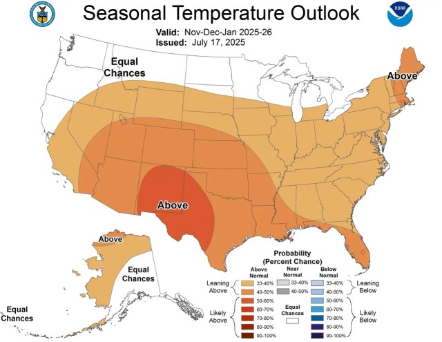
[UPDATED July 18] – Although there are still a couple of ski areas open, that doesn’t mean we can’t start looking ahead to next winter. Yesterday, NOAA updated its long-lead seasonal outlooks, which include the winter 2025-26 season. We thought we’d take a quick look to see what might be in store for the U.S. next year.
Last season, our team of meteorologists graded NOAA a B+ for its long-lead outlook, accurately predicting almost everywhere except California. Will this season be as accurate?
Updated NOAA Winter 2025-26 Outlook (Based on July 2025 Discussion)
Neutral ENSO: A Season of Uncertainty and Potential
The Pacific is holding steady with ENSO-neutral conditions through late summer, indicating no significant El Niño or La Niña influence initially. Moving into fall and winter, there’s a slightly rising chance for La Niña to develop. This matters, as La Niña usually brings colder temps and more snow to the Pacific Northwest and Northern Rockies.
The key takeaway: Expect considerable variability and keep a close eye on monthly updates as the season approaches, since neutral to La Niña transitions can bring surprises.
Mountain Region Snow Forecast
Western Mountains & Rockies
- Temperature Trends: Above-normal temperatures are expected for most of the interior West at the end of summer and into early fall, but confidence in continued warmth decreases for western mountain areas and the Pacific Northwest as winter approaches.
- Snowfall/Precipitation: For early winter (November-January), models favor more typical La Niña-like patterns, with increased chances of above-normal precipitation (snow) in the Northern Rockies and around the Great Lakes/Ohio Valley. Drier-than-average conditions persist across the Southern Rockies and Southwest.
Pacific Northwest
- Key Change from Last Month: Early signs now hint at the first below-normal temperature signals (and potentially earlier snow) across the PNW as early as December–February, a shift from the previously forecasted strong warmth.
- Snow Outlook: If La Niña locks in, powder prospects increase, with colder air and more frequent storms possible by midwinter.
Northeast & New England
- Temperatures: Continued above-average warmth, especially early in the season, but the region remains prone to sharp cold snaps and heavy storms, particularly mid-to-late winter.
- Precipitation: Above-normal precipitation is favored, offering hope for strong base-building and memorable Nor’easters.
Sierra Nevada & Southwest
- Temperature/Precipitation: The Sierra sees less confidence for abnormal warmth; outlook leans slightly drier for the core season. Keep in mind that big storms can break dry spells if La Niña emerges.
Alaska
- West & North: Generally warmer than normal, but notable cold in Southeast Alaska.
- Snow Outlook: Above-normal precipitation for much of Alaska, especially early and late winter, could mean good powder opportunities for adventurous travelers.
What’s Changed Since Last Month?
- The trend toward La Niña is slightly more pronounced, but it is still not certain. Last month showed equal chances for neutral or La Niña; now the pendulum tilts gently toward La Niña for mid- to late winter.
- Early cold signals popped up in the Pacific Northwest that weren’t present a month ago, raising excitement for earlier season storms and more consistent snow cycles in those regions.
- Confidence in ongoing warmth for California’s coastal ranges and Sierra has dipped slightly, meaning a bit more hope for cold snaps.
Outlook Maps

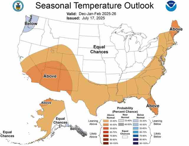

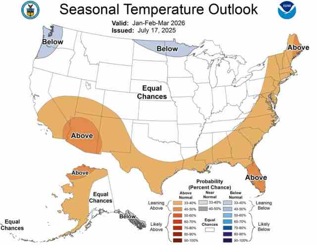

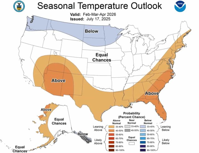

Full NOAA Text Discussion
SUMMARY OF THE OUTLOOK FOR NON-TECHNICAL USERS

El Niño Southern Oscillation (ENSO)-neutral conditions are present, as
equatorial sea surface temperatures (SSTs) are near average across most of the
tropical Pacific Ocean. The latest Niño 3.4 weekly departure was +0.1 degrees
Celsius, which is squarely in ENSO-neutral territory. As such, ENSO-neutral
conditions are most likely through the late Northern Hemisphere summer 2025 (56
percent chance in August-October (ASO)). Thereafter, chances of La Niña
conditions increase into the fall and winter 2025-26, but remain comparable to
ENSO-Neutral. The chances of El Niño are very small (around 10 percent or less)
through the rest of the summer, the fall, and the upcoming winter.

The ASO 2025 Temperature Outlook favors above-normal temperatures for almost
the entire country. The largest probabilities (greater than 50 percent) of
above-normal temperatures are forecast across much of the interior West,
Northeast, and southern Florida, with probabilities exceeding 60 percent for
much of New England. Near-normal temperatures are more likely for eastern
portions of the Alaska North Slope. The ASO 2025 Precipitation Outlook depicts
enhanced probabilities of below-normal precipitation amounts across much of the
northern Plains, Rockies, and Great Basin. Above-normal precipitation is more
likely for much of the eastern third of the Contiguous United States (CONUS)
and most of Alaska. The greatest chances (above 40 percent) of above-normal
precipitation are indicated for the Southeast and portions of central Mainland
Alaska. Equal chances (EC) are forecast for areas where probabilities for each
category of seasonal mean temperatures and seasonal accumulated precipitation
amounts are expected to be similar to climatological probabilities.

BASIS AND SUMMARY OF THE CURRENT LONG-LEAD OUTLOOKS
Note: For Graphical Displays of the Forecast Tools Discussed Below See:
http://www.cpc.ncep.noaa.gov/products/predictions/90day/tools/briefing

CURRENT ATMOSPHERIC AND OCEANIC CONDITIONS

During June 2025, ENSO-neutral continued, with near-average sea surface
temperatures prevailing across most of the equatorial Pacific Ocean. The latest
weekly Niño SST index values ranged from +0.1°C to +0.4°C. Subsurface
temperature anomalies were weakly positive and nearly unchanged from last
month, with mostly above-average temperatures established along the
thermocline. Over the east-central and eastern equatorial Pacific Ocean,
low-level wind anomalies were easterly and upper-level wind anomalies were
westerly. Convection remained enhanced over Indonesia. Collectively, the
coupled ocean-atmosphere system in the tropical Pacific reflected ENSO-neutral.

Dynamical models depict a robust Madden Julian Oscillation (MJO) emerging
across the Western Pacific in mid- to late-July, with eastward propagation into
the Western Hemisphere possible by the end of the month. Increased tropical
cyclone (TC) activity remains likely across the Western North Pacific during
the next 2 weeks tied to the aforementioned enhanced low frequency convective
signal. The developing MJO favors increasing chances of TC development
spreading into the Eastern North Pacific toward the end of July into early
August ending the current lull in TC activity across the Basin. While the
Atlantic is likely to continue to remain quiet in terms of TC activity for the
next few weeks, signs point to this MJO event reaching a more favorable
position in early- to mid-August, possibly leading to increased chances of TC
formation coinciding with the uptick in climatology across the Main Development
Region.

PROGNOSTIC DISCUSSION OF SST FORECASTS

The International Research Institute (IRI) predictions indicate ENSO-neutral is
most likely through the Northern Hemisphere winter 2025-26. In contrast, the
North American Multi-Model Ensemble (NMME) favors the onset of La Niña
conditions during the Northern Hemisphere fall, though lasting a shorter
duration than NOAA's requirement of five consecutive overlapping 3-month
seasons. While the subsurface equatorial Pacific remains above average,
easterly trade winds are predicted to strengthen in the coming month, which
could portend cooler conditions. In summary, ENSO-neutral is most likely
through the late Northern Hemisphere summer 2025 (56% chance in ASO).
Thereafter, chances of La Niña conditions increase into the fall and winter
2025-26, but remain nearly equal to ENSO-neutral.

PROGNOSTIC TOOLS USED FOR U.S. TEMPERATURE AND PRECIPITATION OUTLOOKS

Dynamical model forecasts from the NMME, the Coupled Forecast System Model
Version 2 (CFSv2), and the Copernicus (C3S) multi-model ensemble system were
used extensively for the first six leads when they are available, as was the
objective, historical skill weighted consolidation and Calibration, Bridging,
and Merging (CBaM) guidance, that combines both dynamical and statistical
forecast information.

Antecedent boundary layer conditions such as soil moisture, sea ice extent, and
extratropical SSTs were utilized where appropriate. Additionally, the official
ENSO forecast favors ENSO neutral or La Niña conditions through the upcoming
winter. The anticipated absence of El Niño played a role in the construction of
these outlooks. Composites derived from nearest neighbor statistical analysis
of recently observed tropical Pacific SST and Equatorial heat anomalies were
utilized when relevant. At later leads, decadal trends  in temperature and
precipitation were increasingly relied upon in creating the seasonal outlooks.

PROGNOSTIC DISCUSSION OF OUTLOOKS - ASO 2025 TO ASO 2026

TEMPERATURE

One of the main headlines for the late summer and early fall is the potential
for widespread warmth as above-normal temperatures are favored for virtually
the entire nation. This is not particularly surprising given that the ASO
period has among the largest coverage of warm trends  of any three month period
of the year. These warm trends  are particularly strong in the Northeast, the
interior West, and southern Florida, where probabilities of above-normal
temperatures exceed 50 percent. In the Northeast, above-normal SSTs in the
adjacent Atlantic support even greater confidence (above 60 percent chance) of
above-normal temperatures for much of New England. Enhanced chances of
above-normal temperatures are relatively lower from the Northern Plains to
parts of the Southeast where warm trends  are comparatively weak. Additionally
the soil moisture tool features a probability minimum for portions of the
Central Plains and adjacent Mississippi Valley where above-normal temperature
probabilities are only 33 to 40 percent. Dynamical models  such as the NMME also
depict more uncertainty for parts of the Northern Plains, where probabilities
of above-normal temperatures are also only 33 to 40 percent. SSTs are currently
colder than normal along much of the West Coast and dynamical models  such as
the NMME depict a weaker warm signal there, so confidence of above-normal
temperatures is less along the coast relative to inland areas. Probabilities of
above-normal temperatures are less than 40 percent along much of the central
and southern California coast. Uncertainty is also high for northeastern
Alaska, which is one of the few areas of the country where above-normal
temperatures are not favored. The current distribution of Arctic sea ice is not
as conducive for abnormal warmth across eastern areas of the North Slope
relative to areas farther to the west. For this reason, near-normal
temperatures are favored for eastern areas of the North Slope, while
above-normal temperatures are more likely for western areas. Above-normal
temperatures are favored for most of the remainder of Alaska, with the greatest
confidence across the southeastern portion of the state, consistent with recent
trends.

As we progress to the core fall season (September-November (SON) and
October-December (OND)), warm trends  continue to dominate much of the nation
while early impacts from the anticipated lack of El Niño begin to affect the
forecast pattern later in Fall. Above normal temperatures continue to be
favored for most of the nation in both SON and OND, consistent with trends . The
most confident areas of above-normal temperatures are across the Great
Basin/Central Rockies (SON), areas of the Southwest and Southern High Plains
(OND), and the Northeast (SON and OND), consistent with recent trends .
Uncertainty increases across the Northern Plains and Pacific Northwest where EC
is indicated as trends  weaken later in Fall and increased ENSO impacts
potentially take hold. This increase in uncertainty is supported by the NMME
which has a weak signal across much of the Northern Tier of the CONUS.
Above-normal temperatures are favored for most of the northern two-thirds of
Alaska in both SON and OND, consistent with recent trends . However, near-normal
temperatures continue to be favored for eastern areas of the North Slope due
largely to sea ice considerations. Confidence decreases for most of the
southern third of Alaska where trends  are relatively weaker and ENSO impacts
may decrease above-normal temperature chances later in Fall.

During the cold seasons (November-January (NDJ), December-February (DJF),
January-March (JFM), and February-April (FMA)) the anticipated lack of El Niño
is a main driver informing the forecast. As there is roughly a 90 percent
probability that El Niño conditions will not be present during the winter, the
forecast patterns resemble those more typical of La Niña. Most of the nation is
favored to experience above-normal temperatures in NDJ as warm trends  continue
to dominate much of the country. As we get deeper in the winter season, ENSO
impacts become more evident. The first cold signals  appear in DJF across the
Pacific Northwest and Southeast Alaska, consistent with a lack of El Niño. A
tilt toward below-normal temperatures then appears in JFM over parts of the
Northern Plains and Upper Mississippi Valley and peaks in coverage across the
Northern Tier west of the Great Lakes in FMA. Conversely, the Southern Tier of
the CONUS is consistently favored to be warmer than usual, typical of a lack of
El Niño. Above-normal temperatures are also favored for the East Coast due to
warm recent trends  during the core winter months. Alaska is generally favored
to be warmer than normal across the western and northern Mainland and colder
than normal over Southeast Alaska, consistent with the predicted ENSO state.

Looking ahead to next spring and summer, the pattern is almost exclusively
informed by recent trends . As we get deeper into the warm season, the outlook
favors increased chances of warmer than normal conditions in a U-shaped pattern
covering the western, southern, and eastern CONUS. Warmer than normal
conditions are favored for western Mainland Alaska during spring and then
shifting more toward the eastern part of the state by summer.

PRECIPITATION

The ASO period falls squarely within the peak of the Atlantic Hurricane season.
With an above-normal Atlantic Hurricane season forecast, tropical activity will
be a key wildcard in the precipitation distribution along the Gulf and East
Coasts and adjacent inland areas. Above-normal precipitation is favored along
much of the Eastern Seaboard westward to the Lower Mississippi Valley,
generally following guidance from the final consolidation tool. The northward
extension of the above-normal area is consistent with recent trends  while the
western extension to the central Gulf Coast has some support from the C3S and
is consistent with potential enhanced tropical activity associated with an
above-normal Atlantic Hurricane season. Conversely, below-normal precipitation
is favored from the Northern Plains and Upper Mississippi Valley to the
Northern and Central Rockies and parts of the Great Basin. These areas of
favored dryness are consistent with the final consolidation, recent trends , and
below-normal soil moisture. Above-normal precipitation is favored for most of
Alaska, consistent with the NMME and recent trends .

The fall season (SON and OND) features a transition from greater topical
influences early to greater ENSO influences late. During early fall (SON),
enhanced above-normal precipitation chances continue along much of the East
Coast, consistent with potential increased tropical activity and with the
preceding ASO forecast period. Slightly enhanced above-normal precipitation
probabilities extend westward to the Ohio Valley, with support from the CBaM
tool. Conversely, a dry signal is favored for much of the west-central CONUS
due to a combination of recent trends  and dynamical model support. Later in
fall (OND), the forecast pattern increasingly begins to resemble a La-Niña-like
signature, with above-normal precipitation favored for the Pacific Northwest
and Great Lakes/Ohio Valley and a tilt toward below-normal precipitation
spreading across the Southern Tier. A slight tilt toward above-normal
precipitation is forecast for much of Mainland Alaska in (SON) and increases in
coverage later in fall (OND), consistent with recent trends .

During the cold three-month periods (NDJ, DJF, JFM, and FMA), the predicted
precipitation patterns were remarkably consistent and typical of a lack of El
Niño. The core winter months (DJF and JFM) feature increased chances of
above-normal precipitation for the Northern Rockies and Great Lakes/Ohio Valley
with dryness more likely across the Southern Tier of the CONUS. Above-normal
precipitation is favored for Northern Alaska during late fall/early winter
shifting more toward western Mainland Alaska as the winter progresses.

During next spring and summer, recent trends  favor dryness across the Southwest
early, then shifting to the northwestern CONUS and eventually to parts of the
Northern Plains during the warmer months. Slightly elevated chances of
above-normal precipitation are indicated for much of the East during the core
summer months. Above-normal precipitation is favored for northwestern Alaska
during spring, then shifting to central and southern parts of the Mainland
during summer.

4 thoughts on “[UPDATED: July 18] NOAA Winter 2025-26 Outlook: Long-Lead Seasonal Outlook Gives Sneak Peek of Next Winter”