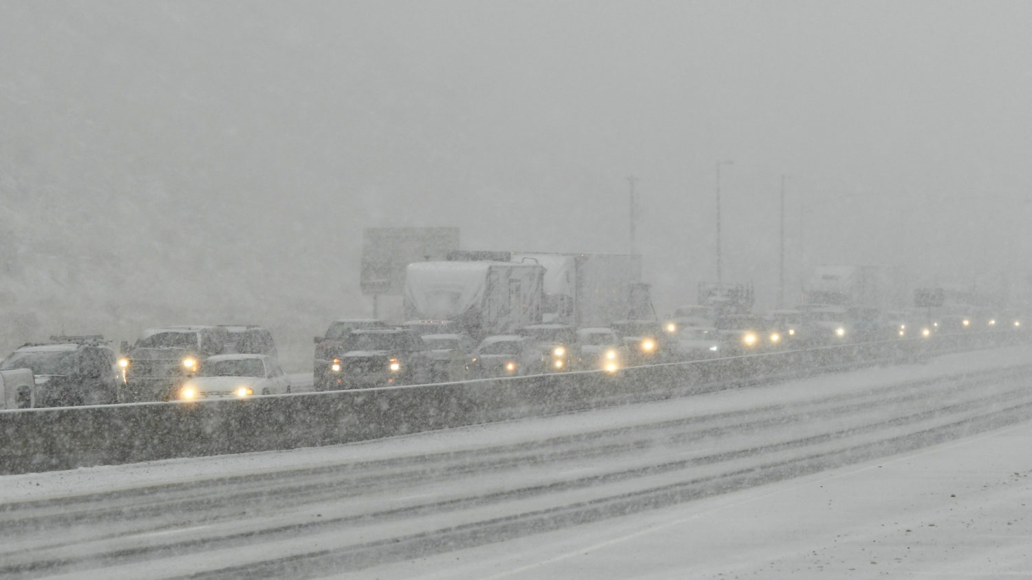
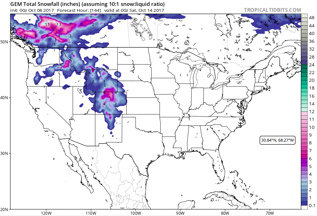
NOAA has issued a Winter Storm Warning for Denver, CO today and tomorrow.
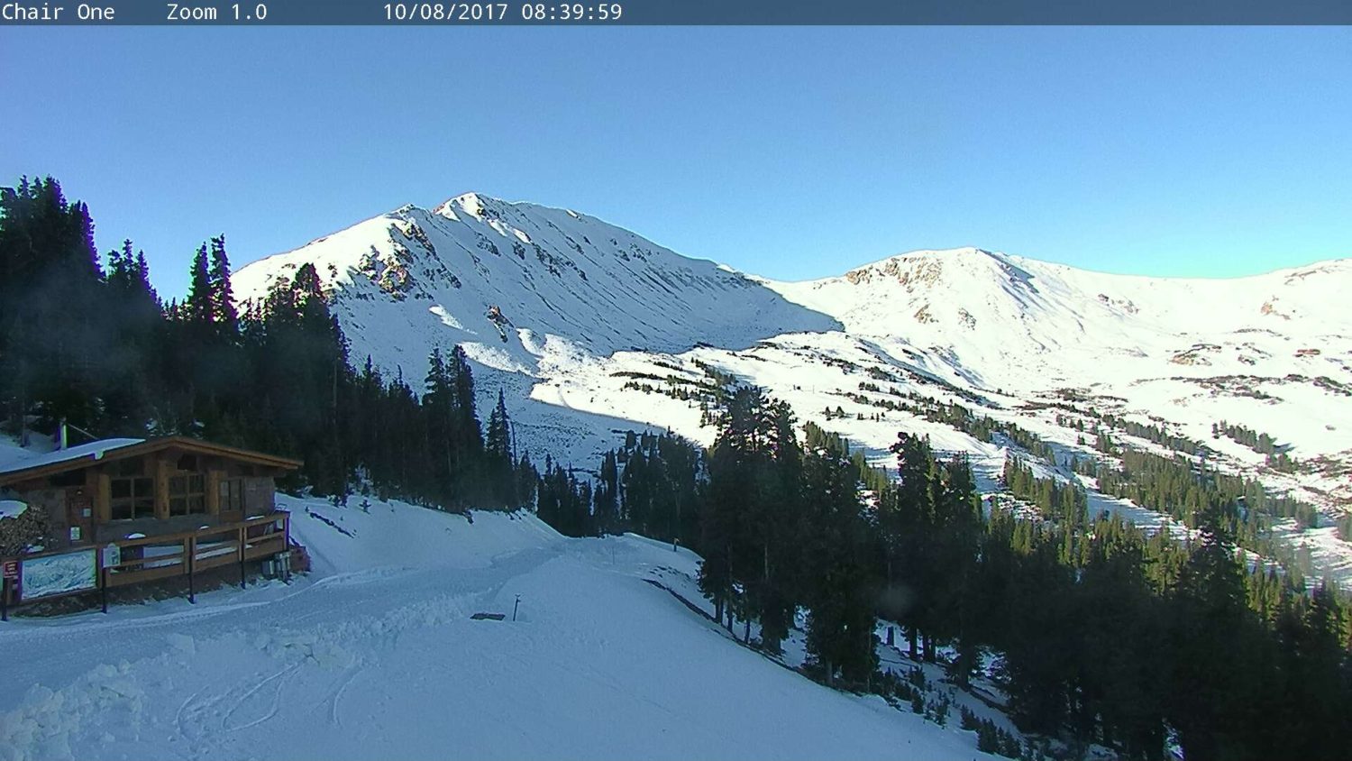
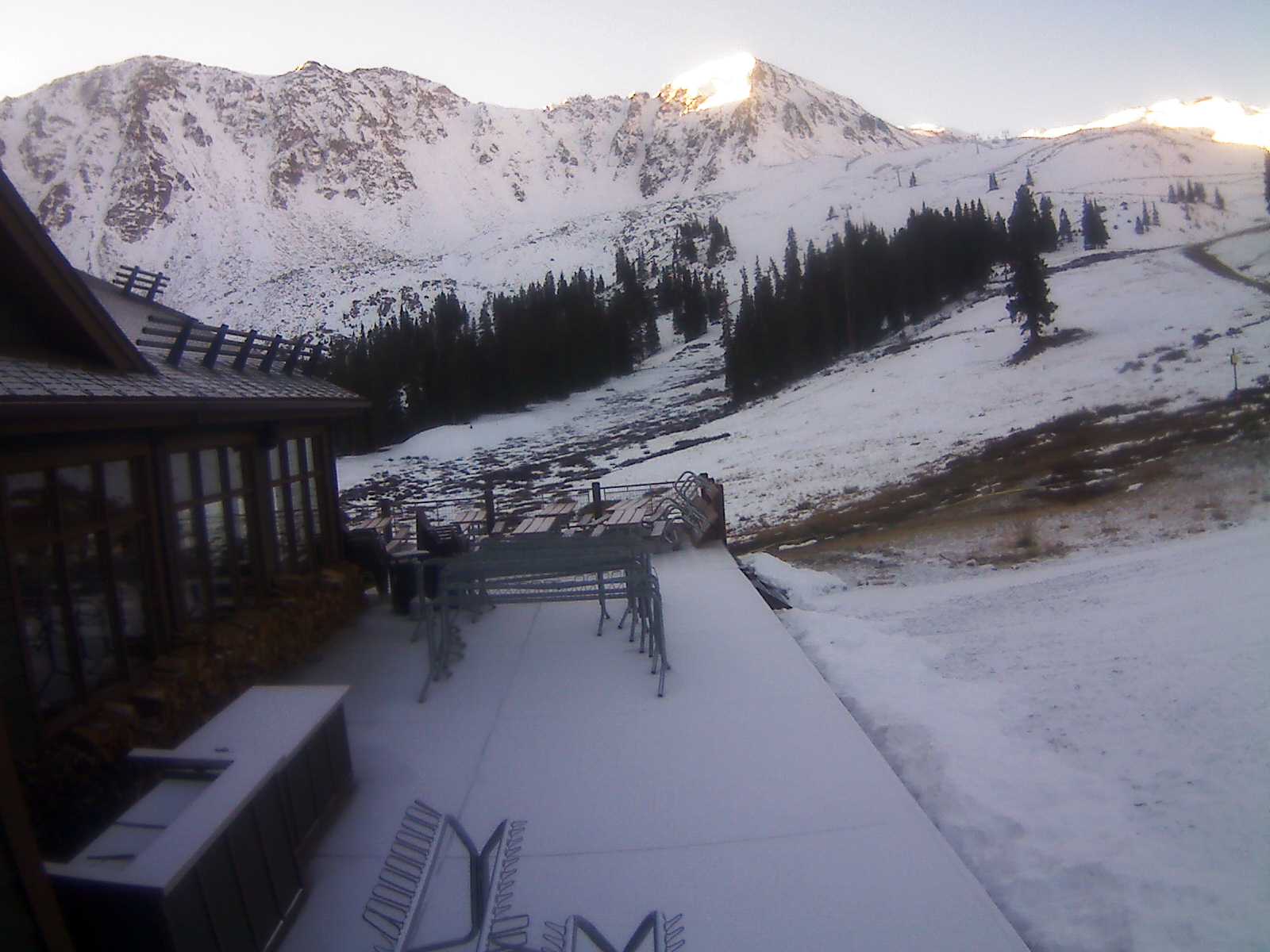
Up to 7″ of snow is forecast in the Denver metro area and up to 14″ of snow is forecast for Arapahoe Basin & Loveland who are currently racing to be the first ski resorts open in North America (Timberline, OR was going to open this weekend on just the Palmer lift, but bad weather kept them closed yesterday. They may or may not open today for the day.)
This new snow may be enough to get Loveland and Arapahoe Basin open this week…

Up to 7″ of snow is forecast for Denver.
* WHAT...Heavy snow expected. Some secondary roads and bridges and overpasses may
become snow or slush covered. Plan on slow and hazardous travel conditions, including
during the morning commute on Monday. Total snow accumulations of 4 to 7 inches are
expected, heaviest amounts near the foothills. - NOAA Denver, CO today
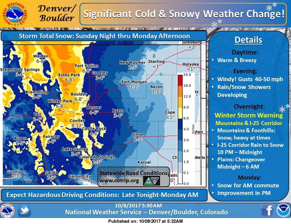
Up to 14″ of snow if forecast in the mountains west of Denver including Breckenridge, Arapahoe Basin, and Loveland.
* WHAT...Heavy snow expected. Plan on difficult travel conditions,including during
the morning commute on Monday. Total snowaccumulations of 6 to 10 inches, with
localized amounts up to 14inches, are expected. - NOAA Denver, CO today
Winter Storm Warning for Denver, CO:
URGENT - WINTER WEATHER MESSAGE
National Weather Service Denver CO
414 AM MDT Sun Oct 8 2017

...SEASON`S FIRST ACCUMULATING SNOW EXPECTED FOR THE I-
25 CORRIDOR...

.A strong cold front and upper level storm system will move into
the area this evening. Temperatures will drop rapidly with the
passage of the cold front. Snow will develop over the mountains
and higher foothills, with rain developing and spreading south during
the evening in lower elevations. Temperatures will turn cold
enough for rain to change over to snow across most of the I-25
Corridor towards the midnight hour and then across the eastern
plains late Sunday night into early Monday morning.

The mild weather today would make an excellent time to prepare
for winter`s return. Check car tires and ensure your emergency
kits, flashlights, blankets, ice scrapers etc. are in place and
all ready to go. Drain outdoor sprinkler systems to protect them
from the well below freezing temperatures expected by Monday
night.

Fort Collins-Boulder and the western suburbs of Denver-Denver-
Castle Rock-
Including the cities of Fort Collins, Hereford, Loveland, Nunn,
Arvada, Boulder, Golden, Lakewood, Longmont, Aurora, Brighton,
City of Denver, Denver International Airport, Highlands Ranch,
Littleton, Parker, Castle Rock, Elbert, Fondis, Kiowa,
and Larkspur
414 AM MDT Sun Oct 8 2017

...WINTER STORM WARNING IN EFFECT FROM MIDNIGHT TONIGHT TO 3 PM
MDT MONDAY...

* WHAT...Heavy snow expected. Some secondary roads and bridges and
  overpasses may become snow or slush covered. Plan on slow and
  hazardous travel conditions, including during the morning
  commute on Monday. Total snow accumulations of 4 to 7 inches are
  expected, heaviest amounts near the foothills.

* WHERE...Fort Collins, Boulder, Denver and Castle Rock.

* WHEN...Midnight to 3 PM Monday.

* ADDITIONAL DETAILS...Scattered power outages may occur due to
  heavy wet snow accumulating on trees still bearing their leaves.
Winter Storm Warning for Arapahoe Basin, CO:
URGENT - WINTER WEATHER MESSAGE
National Weather Service Denver CO
414 AM MDT Sun Oct 8 2017

...SEASON`S FIRST ACCUMULATING SNOW EXPECTED FOR THE I-
25 CORRIDOR...

.A strong cold front and upper level storm system will move into
the area this evening. Temperatures will drop rapidly with the
passage of the cold front. Snow will develop over the mountains
and higher foothills, with rain developing and spreading south during
the evening in lower elevations. Temperatures will turn cold
enough for rain to change over to snow across most of the I-25
Corridor towards the midnight hour and then across the eastern
plains late Sunday night into early Monday morning.

The mild weather today would make an excellent time to prepare
for winter`s return. Check car tires and ensure your emergency
kits, flashlights, blankets, ice scrapers etc. are in place and
all ready to go. Drain outdoor sprinkler systems to protect them
from the well below freezing temperatures expected by Monday
night.

Rocky Mountain National Park and the Medicine Bow Range-
The Mountains of Summit County, the Mosquito Range, and the
Indian Peaks-The Northern Front Range Foothills-
The Southern Front Range Foothills-
Including the cities of Cameron Pass,
Laramie and Medicine Bow Mountains, Rabbit Ears Range,
Rocky Mountain National Park, Willow Creek Pass, Berthoud Pass,
Breckenridge, East Slopes Mosquito Range,
East Slopes Southern Gore Range, Eisenhower Tunnel, Indian Peaks,
Kenosha Mountains, Mount Evans, Williams Fork Mountains,
Winter Park, Estes Park, Glendevey, Nederland, Red Feather Lakes,
Bailey, Central City, Evergreen, Georgetown, Idaho Springs,
and Westcreek
414 AM MDT Sun Oct 8 2017

...WINTER STORM WARNING IN EFFECT FROM 9 PM THIS EVENING TO 3 PM
MDT MONDAY...

* WHAT...Heavy snow expected. Plan on difficult travel conditions,
  including during the morning commute on Monday. Total snow
  accumulations of 6 to 10 inches, with localized amounts up to 14
  inches, are expected.

* WHERE...Rocky Mountain National Park and the Medicine Bow
  Range, The Mountains of Summit County, the Mosquito Range, and
  the Indian Peaks, The Northern Front Range Foothills and The
  Southern Front Range Foothills.

* WHEN...Snow will develop from north to south this evening and
  become heavy at times overnight. Snow will decrease by Monday
  afternoon.

* ADDITIONAL DETAILS...Be prepared for significant reductions in
  visibility at times.
2 thoughts on “NOAA: Winter Storm Warning for Denver, CO Today/Tomorrow | Up to 7″ of Snow Forecast”