
“Winter Storm Warnings and Advisories have been issued for many areas as the first in two systems begins to affect the area. Precipitation will begin late tonight and slowly drop south through day tomorrow bringing plenty of snow to the mountains and northern valleys. Central and southern valleys will likely see rain…or a rain/snow mix before changing to all snow. The next system brings more snow early Monday morning through Tuesday and possibly beyond. A few feet of snow are possible for the mountains when all is said and done and some valleys will likely get some major accumulation as well.” – NOAA Denver, CO today

NOAA has issued Winter Storm Warnings, Winter Storm Watches, & Winter Weather Advisories for Colorado for Saturday.
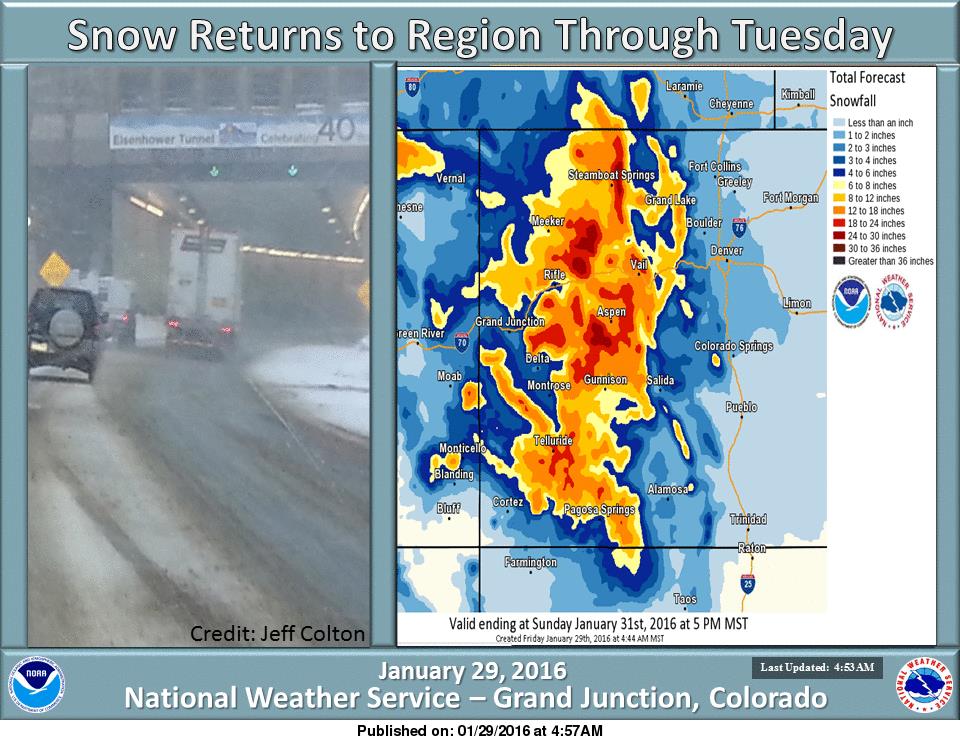
Winter Storm Warning = 8-16″ of snow is forecast around Aspen.
* SNOW ACCUMULATION...8 TO 16 INCHES. - NOAA Denver, CO today
Winter Storm Watch = 8-12″ of snow is forecast around Arapahoe Basin.
Winter Weather Advisory = 6-12″ of snow is forecast around Telluride.
Colorado has had a stellar season so far but hasn’t had a big snowfall in a while. This should be good.
Wolf Creek is winning Colorado this year with 283″ of snowfall this season.

WINTER STORM WARNING for ASPEN, CO AREA:
URGENT - WINTER WEATHER MESSAGE
NATIONAL WEATHER SERVICE GRAND JUNCTION CO
529 AM MST FRI JAN 29 2016

GRAND AND BATTLEMENT MESAS-
GORE AND ELK MOUNTAINS/CENTRAL MOUNTAIN VALLEYS-
WEST ELK AND SAWATCH MOUNTAINS-

...WINTER STORM WARNING REMAINS IN EFFECT FROM 6 AM SATURDAY TO
9 AM MST SUNDAY...

* LOCATIONS INCLUDE THE CITIES OF...SKYWAY...ASPEN...VAIL...
  SNOWMASS...CRESTED BUTTE...TAYLOR PARK...MARBLE.

* TIMING...SNOW AND BLOWING SNOW ARE EXPECTED TO BEGIN SATURDAY
  MORNING. THE HEAVIEST SNOW WILL OCCUR SATURDAY EVENING.

* SNOW ACCUMULATION...8 TO 16 INCHES.

* WINDS...WEST 10 TO 20 MPH WITH GUSTS UP TO 45 MPH.

* IMPACTS...TRAVEL MAY BECOME DIFFICULT. BE PREPARED FOR WINTER
  DRIVING CONDITIONS.
