A major winter storm is still on track to impact the Northern Rockies this weekend.
- NOAA, Great Falls MT, 9/24/19
NOAA has issued a Winter Storm Watch for Northern Montana that is calling for 12-48″ of snowfall Friday – Sunday.
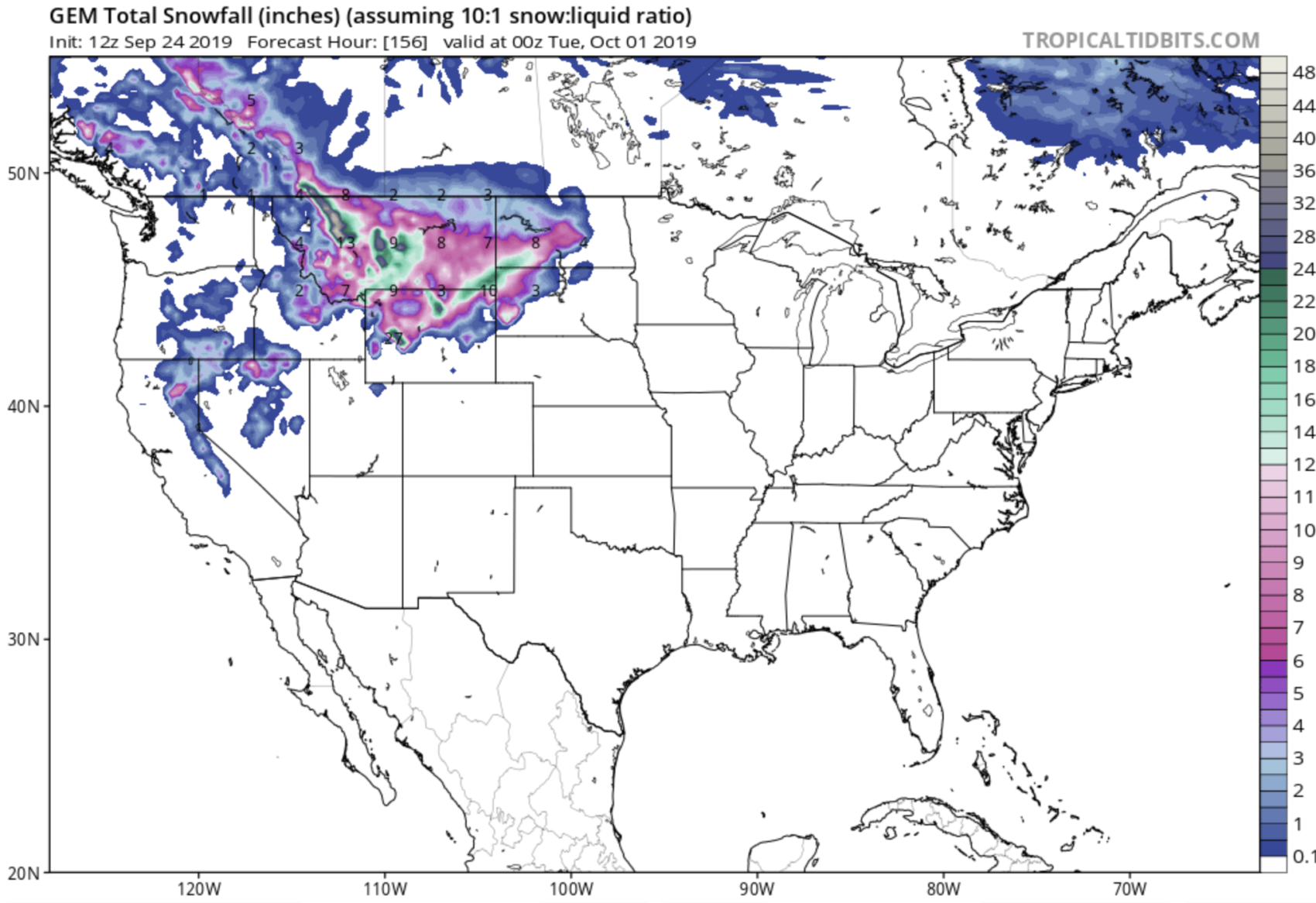
SNOW: Current solutions are indicating 2 to 3 feet of snow Friday
night through Monday for the higher terrain along the Continental
Divide, with a few places potentially getting up to 4 feet.
- NOAA, Great Falls MT, 9/24/19
NOAA is talking about this storm having “extreme impacts” on the region and that “Travel could be very difficult to impossible” Friday – Sunday.
* IMPACTS...Travel could be very difficult to impossible.
- NOAA, Great Falls MT, 9/24/19
This early-season winter storm and/or blizzard has the potential to set a new benchmark for snow accumulations, cold temperatures, and resulting impacts for parts of the Northern Rockies and the Rocky Mountain Front. A similar storm in 1934 produced prolific amounts of snow in late September over North Central Montana. Extreme impacts are possible with this storm, including to the power infrastructure (downed power lines resulting in widespread power outages), agricultural interests, outdoor recreation (camping and hunting activities), and travel. Widespread significant tree damage is possible with the heavy, wet snow and strong winds impacting trees with foliage.
– NOAA, Great Falls MT, 9/24/19
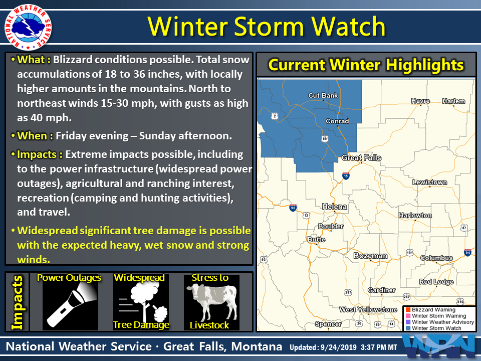
This is only the 2nd winter advisory of the season in the Lower 48 this year.
NOAA expects this Winter Storm Advisory to expand east and south in the near future.
This Winter Storm Watch will likely be expanded further east and south with future forecast to include more of the North Central Montana plains.
– NOAA, Great Falls MT, 9/24/19
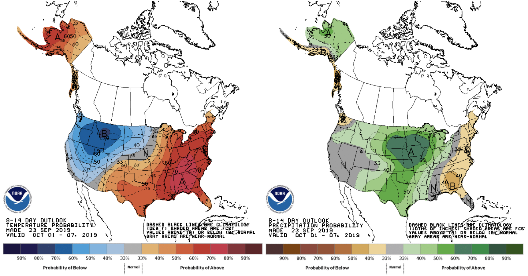
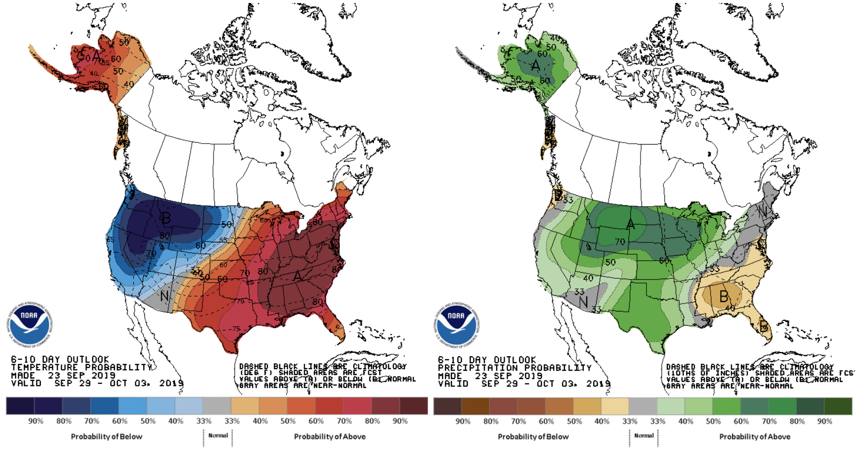
According to the latest GEM & GFS weather models as well as NOAA’s 6-10 day & 8-14 day outlooks, below-average temperatures and above-average precipitation is expected in Montana the next 2 weeks (see outlooks at bottom of article).
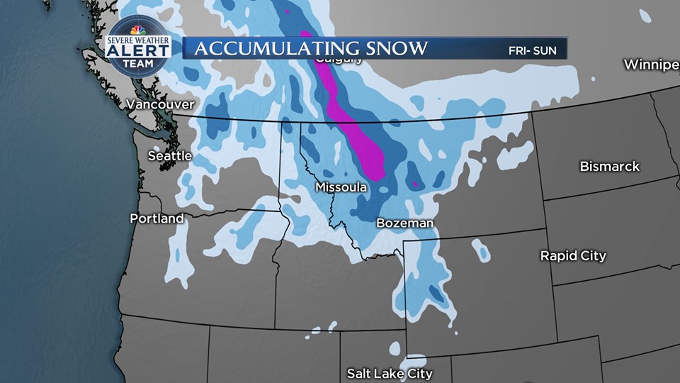
GEM 6-DAY SNOWFALL MODEL:
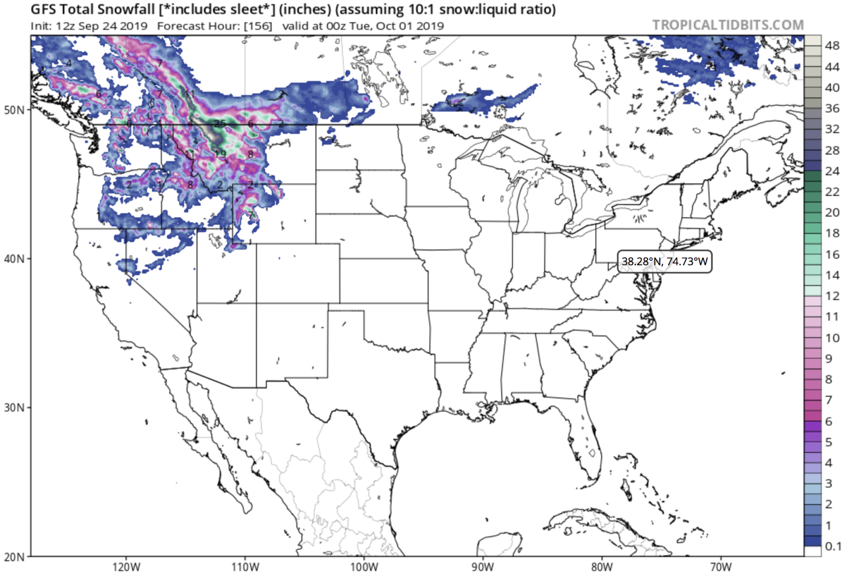
GFS 6-DAY SNOWFALL MODEL:
Snow levels are forecast to drop to most valley floors by Sunday morning.
SNOW: Current solutions are indicating 2 to 3 feet of snow Friday
night through Monday for the higher terrain along the Continental
Divide, with a few places potentially getting up to 4 feet.
Logan, Marias, Rogers, MacDonald, and Homestake passes will have a
significant impact from the snow. Lookout, Lolo, and Lost Trail
passes are anticipated to receive 3 to 8 inches of snow during
this event. Most locations, including valleys, will experience
snow by Sunday morning, with the snow mainly sticking to unpaved
surfaces. The valleys closest to the Divide (Polebridge, Seeley
Lake, Georgetown, and Butte) have the potential to get up to 6
inches of snow, while the lower valleys of Idaho (Orofino to
Riggins) should remain all rain. This amount of snow this early
in the season will also have a major impact to trees, potentially
causing downed trees to block roads and create power outages.
***
Winter Storm Watch for Northern Montana
***
URGENT - WINTER WEATHER MESSAGE
National Weather Service Missoula MT
203 PM MDT Tue Sep 24 2019

West Glacier Region-
203 PM MDT Tue Sep 24 2019

...WINTER STORM WATCH IN EFFECT FROM FRIDAY EVENING THROUGH
SUNDAY AFTERNOON...

* WHAT...Heavy snow possible. Total mountain snow accumulations of
  1 to 3 feet possible. Total valley snow accumulations of 3 to 9
  inches possible. Winds could gust as high as 40 mph.

* WHERE...Bad Rock Canyon, Essex, Highway 83 Bigfork to Swan
  Lake, Marias Pass, and Polebridge.

* WHEN...From Friday evening through Sunday afternoon.

* IMPACTS...Travel could be very difficult to impossible.
NOAA’s 6-10 Day TEMP & PRECIP OUTLOOK:
NOAA’s 8-14 Day TEMP & PRECIP OUTLOOK: