Mid-June powder skiing from a chairlift in California this weekend? It’s looking like a reality at this point…
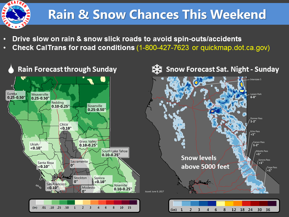
NOAA is forecasting snow this weekend in California’s mountains.
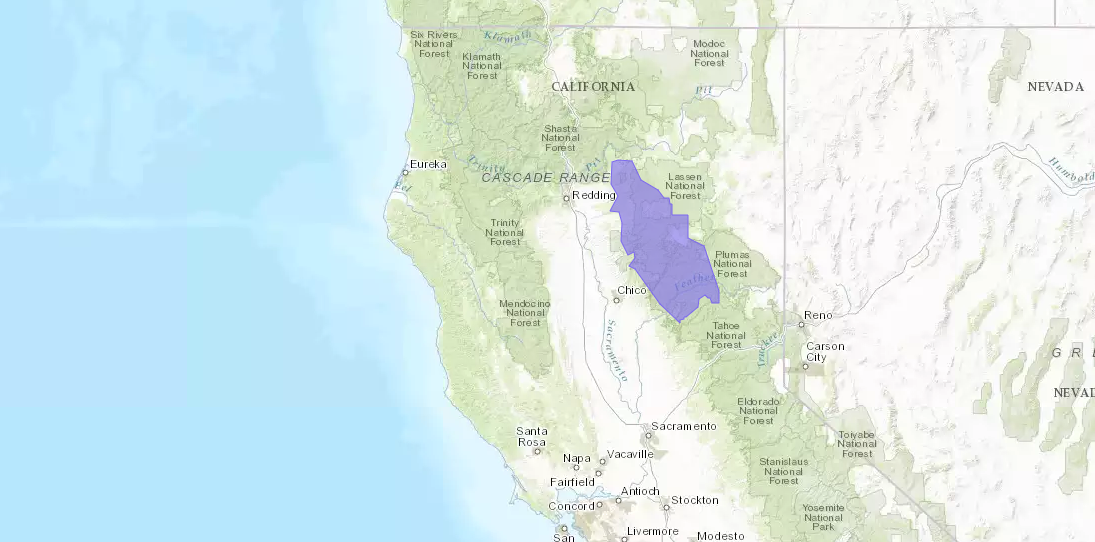
NOAA has issed a WINTER WEATHER ADVISORY for Northeast California and a Special Weather Statement for Tahoe.
* SNOW ACCUMULATIONS...4 to 8 inches possible above 5500 feet
  across Lassen Park. - NOAA Reno, NV today
NOAA is forecasting the following:
- 6-8″ of snow for Mt. Lassen area.
- 2-4″ of snow is forecast all over California above 7,000′.
"Accumulating snow will be possible in the Sierra above 6000 feet
Saturday night through Sunday night with 2-4 inches of snow
possible in the higher elevations above 7000 feet. In northeast
California, 4-8 inches is possible above 6500 feet, with a couple
inches down to 6000 feet." - NOAA Reno, NV today
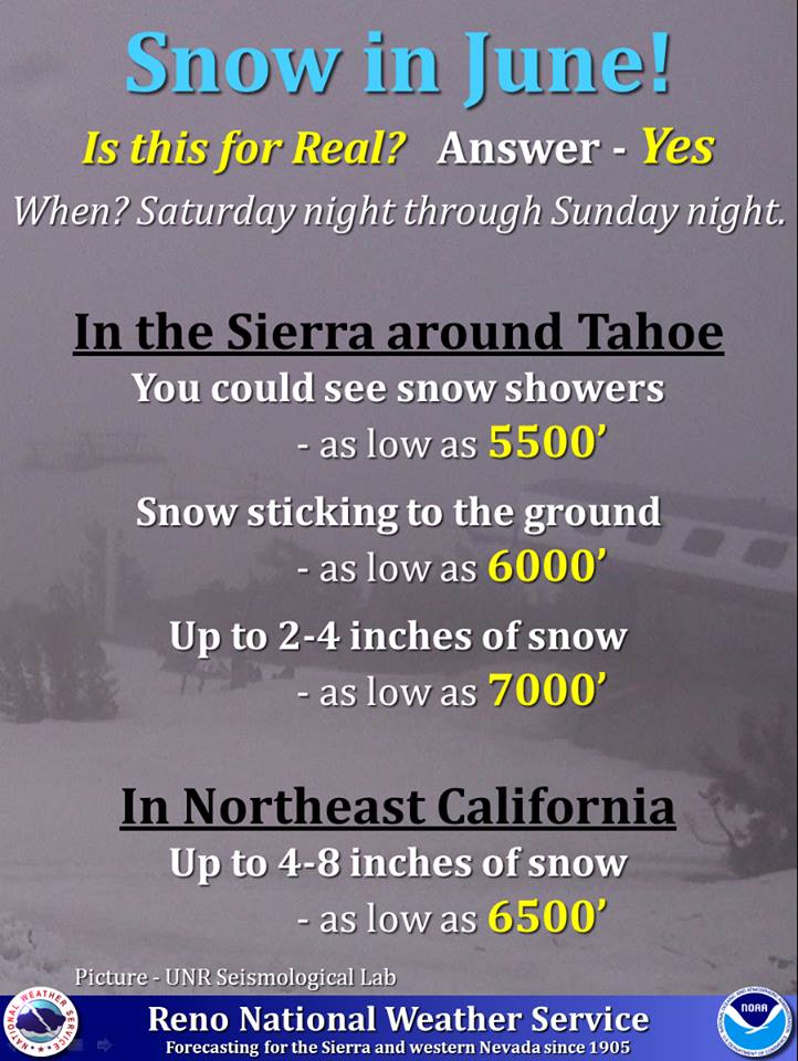
Snow level will drop as low as 5,000′ on Sunday.
“Light showers are going to be possible this weekend with light snow showers possible above 5000 ft on Sunday.” – NOAA Sacramento, CA yesterday
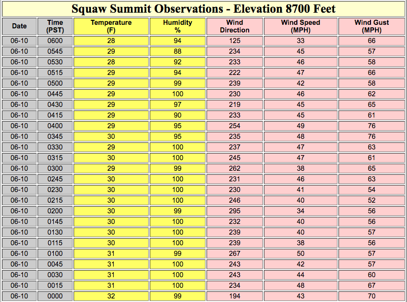
Squaw Valley and Mammoth are open this weekend.
Squaw Valley is experiencing 33-66mph winds as of 6:15am this morning which leads us to believe that a lot (if not everything) may be closed there today.
Winter Weather Advisory for California:
URGENT - WINTER WEATHER MESSAGE
National Weather Service Sacramento CA
507 AM PDT Sat Jun 10 2017

...Late Season Snow Over Lassen Park This Weekend...

.A cool weather system will bring late season snow to the
mountains of northern California this weekend. Snow levels are
expected to drop to near 5000 feet tonight into Sunday. 4 to 8
inches of snow will be possible across Lassen Park, with a couple
inches possible over the high Sierra.

Western Plumas County/Lassen Park-
Including the cities of Chester and Quincy

...WINTER WEATHER ADVISORY REMAINS IN EFFECT FROM MIDNIGHT
TONIGHT TO MIDNIGHT PDT SUNDAY NIGHT...

* MAIN IMPACTS...Slick roads may bring spin-outs and longer
  travel times. Outdoor events and recreation may be impacted.

* TIMING...Saturday night through Sunday.

* LOCATIONS...Lassen Park.

* SNOW ACCUMULATIONS...4 to 8 inches possible above 5500 feet
  across Lassen Park.

PRECAUTIONARY/PREPAREDNESS ACTIONS...

A Winter Weather Advisory for snow means that periods of snow
will cause primarily travel difficulties. Be prepared for snow
covered roads and limited visibilities, and use caution while
driving.
Special Weather Statement for California:
Special Weather Statement
National Weather Service RENO NV
357 AM PDT Sat Jun 10 2017

Surprise Valley California-Lassen-Eastern Plumas-
Eastern Sierra Counties-Greater Lake Tahoe Area-Mono County-
Mineral and Southern Lyon Counties-Greater Reno-Carson City-
Minden Area-Western Nevada Basin and Range including Pyramid Lake-
Northern Washoe County-
Including the cities of Cedarville, Eagleville, Fort Bidwell,
Portola, Susanville, Westwood, Sierraville, Loyalton,
South Lake Tahoe, Tahoe City, Truckee, Markleeville, Bridgeport,
Coleville, Lee Vining, Mammoth Lakes, Hawthorne, Yerington,
Smith Valley, Mina, Schurz, Stateline, Glenbrook,
Incline Village, Sparks, Verdi, Gardnerville, Virginia City,
Fernley, Fallon, Lovelock, Silver Springs, Nixon, Imlay, Empire,
and Gerlach

...Storm to Bring Winter-Like Conditions Back to the Region
Sunday...

A strong storm dropping into the region will bring back winter-like
conditions Sunday with high temperatures as much as 25 degrees
below normal. With rain and snow showers, overcast skies and
breezy winds, the temperatures will feel downright frigid,
especially considering it is June.

Overnight low temperatures in the Sierra could stay below
freezing for as many as 3 to 4 more nights. Monday morning will
be the greatest concern in western Nevada with colder valleys
outside of urban centers likely dropping into the mid 30s for
lows. Anyone with sensitive vegetation in these areas should take
the necessary precautions.

Accumulating snow will be possible in the Sierra above 6000 feet
Saturday night through Sunday night with 2-4 inches of snow
possible in the higher elevations above 7000 feet. In northeast
California, 4-8 inches is possible above 6500 feet, with a couple
inches down to 6000 feet. Mountains in western Nevada are also
likely to see several inches of snow accumulation, with up to an
inch for locations such as the Virginia City highlands. With the
June sun angle, snow will melt off rapidly with impacts to
mountain passes likely to be short-lived. However, even a short
burst of accumulating snow can cause a significant travel hazard,
so slow down if you end up in any snow showers.

Anyone planning outdoor activities this weekend should be prepared
for very cold temperatures and the potential for accumulating snow.
This is a dramatic change in weather, and unusual for this time of
year, so plan ahead.