 Weather


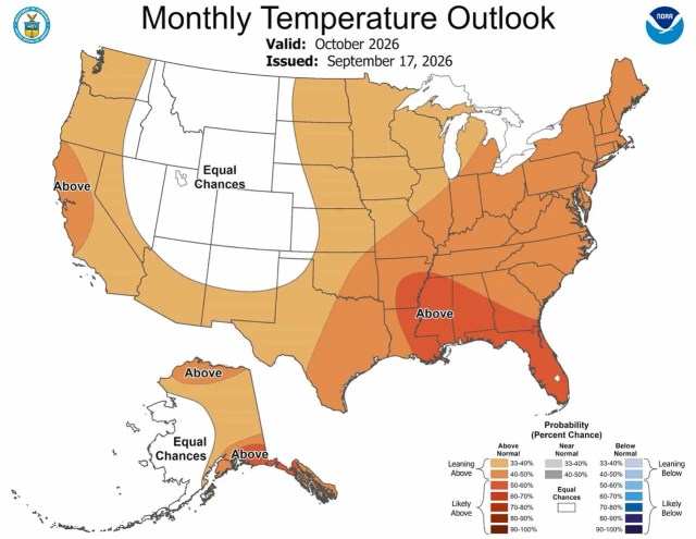
NOAA‘s October 2026 mountain weather outlook lands at the most consequential moment on the ski calendar. It decides which resorts fire snowguns first, which high-alpine routes hold their summer snow into opening day, and, after a 2025–26 season that was one of the worst on record across the American West, whether skiers have any reason to start believing again. NOAA’s Climate Prediction Center released its monthly outlook for October 2026 on September 17, and for the mountains, the news is genuinely mixed. That, after last winter, qualifies as progress.
- Related: Old Farmer’s Almanac Winter Forecast Reveals 2026-27’s Snowiest States
- Related: Farmers’ Almanac Winter 2026-27 Forecast: Prepare for a Winter of Snow
Here is what forecasters are calling for, region by region.
The Big Picture: El Niño Is Running the Show
For the first time in two years, a growing El Niño — not La Niña — is the dominant force shaping the U.S. weather pattern. NOAA declared El Niño conditions on June 11, 2026, and the event has strengthened significantly since. By September, forecasters placed a 98% chance on a very strong El Niño event peaking in October through December 2026. If those numbers hold, this could be the strongest El Niño since records began.
That matters for skiers. Strong El Niño events historically shift the main Pacific storm track southward, loading the Sierra Nevada and southern Rockies with frequent, moisture-rich systems while leaving the Pacific Northwest and northern Rockies drier and warmer than normal. October’s outlook reflects exactly that split — but with important nuances that mountain communities need to understand before concluding about the season ahead.
One source of uncertainty worth noting: an active West Pacific tropical cyclone season could send a recurving storm into the higher latitudes of the North Pacific in October. If that happens, it could disrupt the downstream pattern over North America and introduce volatility into an already complex forecast.
October 2026 Mountain Weather Outlook: Reading the Temperature Maps
Pacific Northwest and Cascades: Warm Signal Limits Early-Season Snowmaking
The warmest temperature signal in the West sits along the coast. Above-normal temperatures are favored for Washington and Oregon’s western slopes, with probabilities in the 33 to 40 percent range. For Cascade ski areas targeting October snowmaking windows, warmth at lower elevations will compress those windows. Crystal Mountain, Mt. Hood Meadows, and Mt. Bachelor will need sustained overnight cold at elevation to build meaningful early-season bases. October rarely delivers that in a warm coastal pattern, and this outlook does not change that calculus.
Interior West Temperature Forecast: Equal Chances Across the Rockies and Sierra
This is the most significant temperature story for the Mountain West. A large band of Equal Chances, meaning no tilt toward warm or cold, covers the interior West, including Colorado, Utah, Wyoming, Idaho, Nevada, and the interior of California. That is actually a relative upgrade.
Why? The El Niño composites, which represent the typical pattern during strong El Niño events, actually favored cooler-than-normal conditions for much of this zone. The dynamical models — which simulate the actual physics of the atmosphere in real time — pushed back with a warmer signal. The two sets of tools disagreed enough that forecasters called it a wash.
The practical implication for ski areas: a neutral temperature outlook for October means the high-elevation Rockies retain a realistic shot at cold nights, natural snowfall, and productive snowmaking. Arapahoe Basin in Colorado is projecting an opening around October 24, while Loveland is targeting somewhere between mid-October and early November; both resorts depend on sustained cold at over 12,000 feet. The EC temperature call does not rule that out.
Arizona and New Mexico lean slightly above normal, with a 33 to 40 percent probability of warmer-than-average October conditions. That is a soft signal, driven primarily by long-term warming trends rather than a strong El Niño push.
Southern Plains and Southeast: Heat Amplified by Drought
The hottest October signal in the country sits well south of any ski terrain. Intensifying drought across the Lower Mississippi Valley and surrounding areas has baked the soil dry, and forecasters expect that dry, low-moisture soil to amplify daytime heat into October. Probabilities of above-normal temperatures exceed 50 percent across this zone. For the southern Appalachians, including Appalachian ski resorts in Tennessee and North Carolina, the outlook is above normal along the coast but more ambiguous farther inland.
Alaska Temperature Outlook: Above Normal in the Southeast, Uncertainty Elsewhere
Southeastern Alaska faces above-normal temperatures, driven by strong agreement among the calibrated models. The North Slope also warms, a consequence of reduced sea ice extent. For Alyeska Resort near Anchorage, the temperature picture is more uncertain, sitting closer to the equal chances zone.

October 2026 Mountain Weather Outlook: Reading the Precipitation Maps
Pacific Northwest and Northern Rockies: Equal Chances, No Confirmed Dry Signal
This is where the October outlook diverges sharply from the full-winter El Niño playbook. In a typical strong El Niño October, the Pacific Northwest and Northern Intermountain West would run drier than normal as the storm track shifts south. The models are not fully playing along, at least not yet. NOAA forecasters found insufficient support from the calibrated dynamical models and statistical tools to back the drier El Niño signal, so Equal Chances of below, near, or above-normal precipitation are forecast for the Pacific Northwest and Northern Intermountain West.
For the Cascades and Northern Rockies, this is cautiously welcome news. Equal Chances is not a wet forecast, but it is not the dry door slamming shut either. A well-timed early-October Pacific system could still deliver meaningful mountain snow to the Washington and Oregon ranges before the month’s warm temperature bias takes hold.
-
 1
Alta, UT, Report: “How Much Did It Actually Snow?” | Dispelling the Misinformation in Little Cottonwood Canyon
-
2
The 13 Largest Ski Resorts on Earth, Ranked by Size
-
3
23-Year-Old Local Speed Rider Dies on the North Face of Chamonix’s Aiguille du Midi [UPDATED]
-
4
Norwegian World Cup Champion Aleksander Aamodt Kilde Tears Achilles While Training in Chile
-
5
SnowBrains 2026-27 Ski Season Forecast, Region by Region: El Niño Favors the High Sierra Over the Northern Rockies


Southwest and Colorado: The Wet Signal in the October 2026 Mountain Weather Outlook
The most important precipitation story for early-season mountain snowpack sits over the Southwest and parts of the southern Rockies. Models agree on an elevated chance of above-normal precipitation across a broad corridor stretching from southern California and Arizona northeastward through New Mexico, Colorado, Kansas, and into the Great Plains and Gulf Coast.
The first half of October is particularly favored. NOAA’s ensemble models show a 500-hPa trough, essentially a dip in the upper-level wind pattern, parked near the West Coast in early October, which would funnel moisture from the Pacific and Gulf into the Southwest and Plains. Southern California gets a boost from an expected active East Pacific hurricane season, which can spin additional moisture into the coastal ranges.
For Colorado, the news is meaningful. The October outlook shows above-normal precipitation probabilities extending from the Four Corners eastward across the southern Plains, representing an upgrade for Colorado ski areas still licking their wounds from the worst snowpack season in the state’s recorded history. Whether that October moisture arrives cold enough to fall as snow at 10,000 feet or above, rather than rain, is the critical variable, and one the monthly outlook cannot resolve. But wet ground, recharged soils, and a pattern that favors active systems are the right foundation for early snowmaking.
New Mexico and Arizona also sit in the elevated wet zone. Ski Santa Fe, Taos Ski Valley, and Arizona Snowbowl could see above-normal precipitation as the subtropical jet begins to fire up, a pattern consistent with what historically delivers 120 to 160 percent of normal winter precipitation to the Four Corners states during strong El Niño events.
Eastern Mountains and Alaska: Equal Chances From the Appalachians to Anchorage
Equal Chances of below, near, or above-normal precipitation cover virtually all of New England and the Mid-Atlantic. Forecasters note that weak signals and high uncertainty at monthly lead times make a definitive call impossible for the East. After a strong 2025–26 season in the East, a stark contrast to the West’s historic collapse, Appalachian resorts enter October on a solid footing, though October snowfall at low-elevation eastern terrain is always weather-dependent regardless of the large-scale pattern.
Alaska
Southeastern Alaska and coastal southern Alaska pick up elevated probabilities of above-normal precipitation in October, driven by model consensus and the ongoing active North Pacific pattern. For Alyeska, that means a reasonable chance of an early build on the upper mountain.
What It Means for the Season Ahead
October’s outlook captures El Niño in its early stages, a pattern still establishing itself rather than one that has locked in. The key takeaway for mountain communities is this: the interior Rockies enter October with a neutral temperature call and a wet precipitation lean, which is a combination that can produce real early-season snow at elevation if the timing and cold align. The Southwest and southern Rockies carry the strongest wet signal in the country. The Pacific Northwest faces above-normal coastal temperatures but no confirmed dry signal, leaving the Cascades in genuine uncertainty.
For Colorado specifically, the early race is already taking shape. After a season in which the state’s April 1 snowpack averaged just 22% of the 30-year median, resort operators and skiers are watching October closely. A wet start to the month, combined with high-elevation cold, could set a very different tone than last year.
The broader winter picture is being shaped by what may become the strongest El Niño on record. NOAA’s September 2026 forecast places a 75% chance on a historic El Niño event peaking in October through December 2026, a level of strength that would push the storm track decisively toward the Sierra Nevada and southern Rockies for the months that follow. October is the setup month. If it delivers, the season could open on a genuinely different trajectory than the one that defined 2025–26.
