NOAA just released their latest Official El Nino update today.
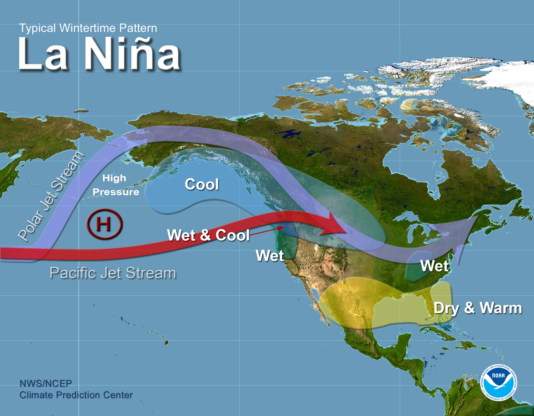
For the first time, NOAA is saying that La Nina is possible in Fall 2016. This is HUGE news as strong La Nina’s have a reputation for unloading snow on the entire USA!
“A transition to ENSO-neutral is likely during late Northern Hemisphere spring or early summer 2016, with a possible transition to La Niña conditions during the fall.” – NOAA, today
(video: “Attack of La Nina, the Bitch is Back” by MSP documenting the epic La Nina winter of 2011)
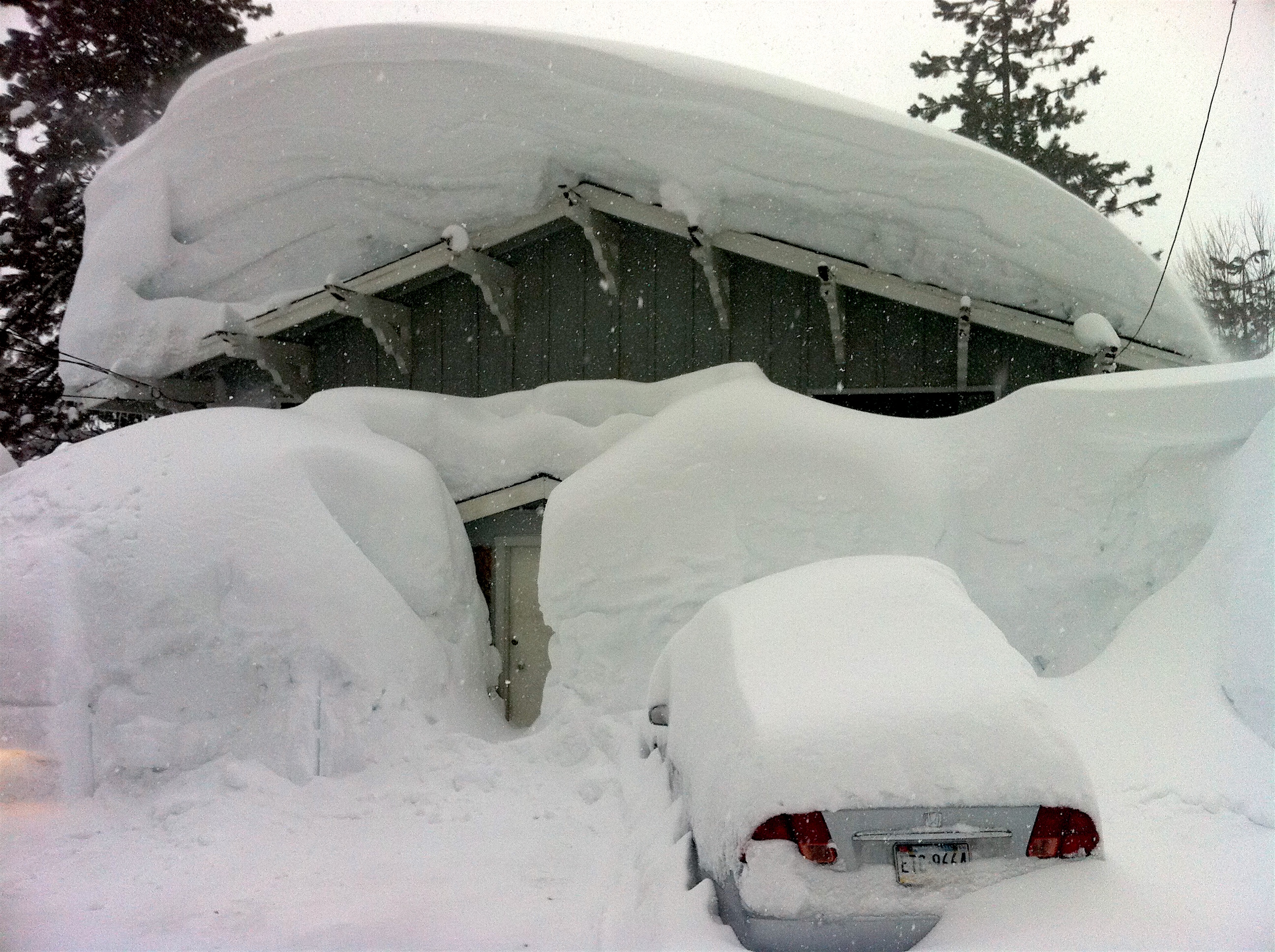
Last time there was a strong La Nina was in 2010/11 when the USA got buried in snow including Squaw Valley, CA receiving 811″ of snowfall!
2010/11 Snowfall Totals:
- Alpine Meadows, CA = 852″
- Squaw Valley, CA = 811″
- Mt. Baker, WA = 808″
- Alta, UT = 723″
- Mammoth, CA = 668″
- Mt. Bachelor, OR = 665″
- Whistler, B.C. = 622″
- Jackson Hole, WY = 557″
- Jay Peak, VT = 376″
“The strong 2010-11 La Niña contributed to record winter snowfall, spring flooding and drought across the United States, as well as other extreme weather events throughout the world, such as heavy rain in Australia and an extremely dry equatorial eastern Africa.” – NOAA, September 2011
The last time we had an El Nino as strong as the current El Nino was in 1997/98 and we had a strong La Nina and the Western US got clobbered with snow in 1998/99. That was year that Scott Gaffney made the best ski movie ever made: “1999”
We’re really fired up about NOAA talking about La Nina… as you can tell.
LA NINA!!!!!!!
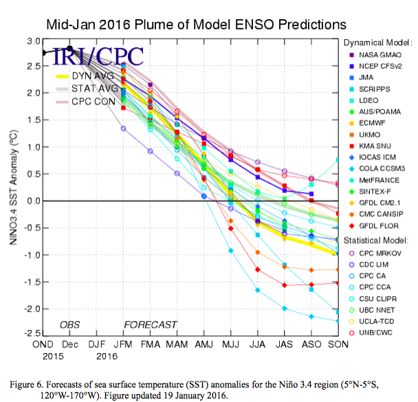
“Most models indicate that El Niño will weaken, with a transition to ENSO-neutral during the late spring or early summer 2016 (Fig. 6). Thereafter, the chance of La Niña conditions increases into the fall. While there is both model and physical support for La Niña following strong El Niño, considerable uncertainty remains. A transition to ENSO-neutral is likely during late Northern Hemisphere spring or early summer 2016, with a possible transition to La Niña conditions during the fall (click CPC/IRI consensus forecast for the chance of each outcome for each 3-month period).” – NOAA, today
(video: watch Scott Gaffney’s mom Bunny Gaffney rip the shit out of Bridger Bowl, MT during the big winter of 1999.)
EL NIÑO/SOUTHERN OSCILLATION (ENSO) DIAGNOSTIC DISCUSSION
issued by
CLIMATE PREDICTION CENTER/NCEP/NWS
and the International Research Institute for Climate and Society
11 February 2016
ENSO Alert System Status: El Niño Advisory
Synopsis: A transition to ENSO-neutral is likely during late Northern Hemisphere spring or early summer 2016, with a possible transition to La Niña conditions during the fall.

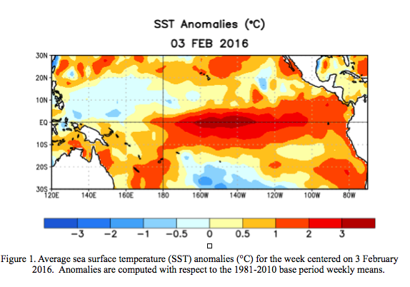
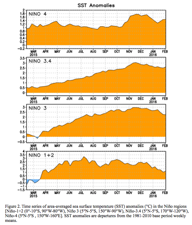
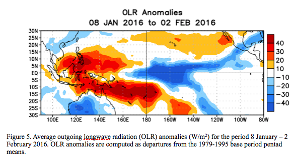
Indicative of a strong El Niño, sea surface temperature (SSTs) anomalies were in excess of 2°C across the east-central equatorial Pacific Ocean during January (Fig. 1). The Niño indices in the eastern Pacific declined, while Niño-3.4 and Niño-4 were nearly unchanged (Fig. 2). The subsurface temperatures in the central and eastern Pacific increased due to a downwelling Kelvin wave (Fig. 3), but toward the end of the month weakened again in association with the eastward shift of below-average temperatures at depth in the central Pacific (Fig. 4). Also, low-level westerly wind anomalies and upper-level easterly wind anomalies continued over much of the tropical Pacific. The traditional and equatorial Southern Oscillation Index (SOI) values remained negative but weakened relative to last month. Convection remained much enhanced over the central and east-central tropical Pacific and suppressed over Indonesia (Fig. 5). Collectively, these anomalies reflect the continuation of a strong El Niño.
Most models indicate that El Niño will weaken, with a transition to ENSO-neutral during the late spring or early summer 2016 (Fig. 6). Thereafter, the chance of La Niña conditions increases into the fall. While there is both model and physical support for La Niña following strong El Niño, considerable uncertainty remains. A transition to ENSO-neutral is likely during late Northern Hemisphere spring or early summer 2016, with a possible transition to La Niña conditions during the fall (click CPC/IRI consensus forecast for the chance of each outcome for each 3-month period).
El Niño has already produced significant global impacts and is expected to affect temperature and precipitation patterns across the United States during the upcoming months (the 3-month seasonal outlook will be updated on Thursday February 18th). The seasonal outlooks for February – April indicate an increased likelihood of above-median precipitation across the southern tier of the United States, and below-median precipitation over the northern tier. Above-average temperatures are favored in the North and West, and below-average temperatures are favored in the southern Plains and along the Gulf Coast.

One thought on “Official NOAA El Nino Update: La Nina Possible Next Winter!”