With just about a month until most lifts start spinning, the biggest question of all still looms. Where will the snow go? SnowBrains is here to help with a composite North American forecast. Drawing from NOAA, the Old Farmers Almanac, AccuWeather, and more take a deep dive into the season’s data.
What We Know:
The season got off to a quick start in Colorado with the opening of both Arapahoe and Keystone. In addition, Montana saw massive amounts of early season snow and is currently at 6600% of average (not a typo).
Overview:
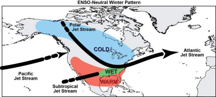
At the moment, there is an 85% probability for an ENSO neutral phase, since neither El Niño nor La Niña is present. As a result, the southern and polar jet streams run closer, channeling weather directly along the systems but also making things more unpredictable, especially for the Pacific jet stream. Find out more at our ENSO Update or dive deeper into our regional breakdown.
CA, Sierras: Average Precipitation and Warmer Temperatures
Beyond the unpredictable effects of ENSO, California is forecast to have average precipitation together with average temperatures making for a normal winter. NOAA calls for warmer temperatures while most other forecasts contradict this.
“At times, these areas could also have back-and-forth conditions, between some periods of dry weather and some active weather in the early winter, which is not really typical,” AccuWeather Expert Long-Range Forecaster Paul Pastelok said.
Because of the changing ENSO probability and variable ocean temperature, California’s situation could change dramatically as a result of individual weather systems. Luckily, the Big Bad Blob warm water resurgence that preceded the 3-year drought is reportedly isolated to the water surface meaning that it may dissipate throughout the winter. Generally, California may not have a 16′ or 19′ season but individual systems in the Pacific will result in the primary seasonal weather.
PNW, Cascades: Average Snow and Temperature
While the majority of forecasts call for normal temperatures and precipitation, there is a fair bit of variability. NOAA generally predicts warmer temperatures across the west coast. But the Farmers Almanac calls for colder temperatures. The PNW will carry the brunt of this uncertainty this year since the Pacific Je Stream will be the main source of winter weather. Although, ski areas are not too worried about an ENSO neutral year.
“At Mt. Hood Meadows, a 39-year history comparing ENSO-neutral conditions to seasonal snowfall, shows it is likely we will have an above average snow year.” – Mt. Hood Correspondent
While Mt. Hood is optimistic, generally, the reliable parade of weather systems generated by El Niñn or the Polar Jet stream won’t be present in the Northwest this year. Instead, the PNW will be largely reliant on Northern Pacific systems which although difficult to predict are usually quite regular.
CO, UT, NM: Central Rockies: Variable Temperature and Precipitation
With the only consensus being variability, it seems the central Rockies will be in for an exciting season. Largely depending on how far north the tropical jet streams ranges and how far south the polar jet stream reaches, the central Rockies will be in the middle of wild temperature and precipitation changes.
According to local Meteorologist Chris Tomer “This winter will not be like last winter. We’re going into what we call a “neutral phase” where the water in the south Pacific near the equator is cooling down. That pushes the southern branch of the jet stream up, brings down the polar jet a little bit more, so the two are going to be running very close– see-sawing this winter…I think parts of the central and southern mountains will be snowier than normal and also warmer than normal.”
NOAA and Tomer agree on average to slightly warmer temperatures. There is consensus on average to above-average precipitation together with more weather activity. The central Rockies’ situation will depend largely on how the jet streams relocate various weather systems as the season progresses.
WY, MT, ID, Northern Rockies: Snowy and Cold
Early season snow, cold temperatures, and the polar jet stream. Almost all forecasts agree that the northern Rockies will see a big winter. The polar vortex’s cooling effect together with an area of active weather and high precipitation over large mountains will provide a great recipe for snow.
According to Accuweather’s Paul Pastelok, “The polar vortex is particularly strong this year, and that means that frigid air is likely to remain locked up over the polar region early in winter.”
Specifically, the ENSO neutral pattern could create a northern storm track directed through polar air. The result…lots of snow. Together with record-setting early season snow and temperature lows, these patterns may already be taking shape
East Coast: Wet, Cold, Wild, and Wintry
Cold temperatures directed by the polar jet stream in addition to Atlantic systems will provide a stormy winter. Specifically, precipitation will be above average while experts also agree that the onset will come more toward early 2020. Specifically, the whole east coast will see a variety of winter weather systems.
According to Accuweather:
“Once the wintry weather does gets underway, an active season will be in store. Whether or not it’s snowstorms, ice storms or mixed events, I do feel this is going to be an active year for the Northeast with above-normal snowfall for areas from New York City to Boston. Meanwhile, cities farther south, including Washington, D.C., and Baltimore, will be more likely to get a mix of rain and snow.”
In addition, the Almanac continues its colder theme with the perspective of another super-winter.
“This could feel like the never-ending winter, particularly in the Midwest and east to the Ohio Valley and Appalachians, where wintry weather will last well into March and even through the first days of spring,”
Generally, the polar jet streams relocation during an ENSO neutral year would direct weather to the east coast. Once the wintry weather does get underway, the east coast would be right at the end of the key weather pattern dictating this season.
Conclusion:
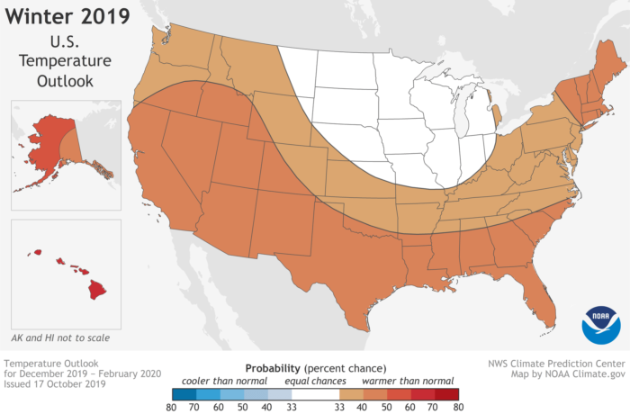
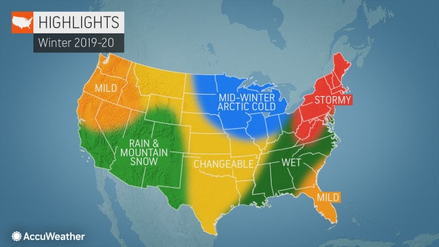
Generally, most forecasts are calling for slightly warmer temperatures in the west, colder temperatures throughout the northern Rockies and east, and a variable buffer zone in the middle. This is mainly a result of the Polar Jet Stream and Tropical Jet stream relocating because of ENSO neutral conditions. The Polar jet stream is predicted to deliver the goods (and has already started to do so across Montana and Alberta). Similarly, the Pacific jet stream could turn into almost anything, while the tropical jet stream will create warmer areas. The best bet… keep on doing your snow dances/prayers. We are all hoping for the best.
To take a closer look at some of our sources, check out:
- Accuweather US: AccuWeather Releases Their Winter 2019/20 Prediction: The Mountains Will Get Snow…
- Old farmer’s Almanac: Old Farmer’s Almanac Winter 2019/20 Forecast: Never-Ending Winter Will Bring Big Chills and Piles of Snow
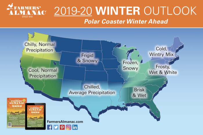
- Farmer’s Almanac: Farmers’ Almanac 2019/20 Winter Outlook:
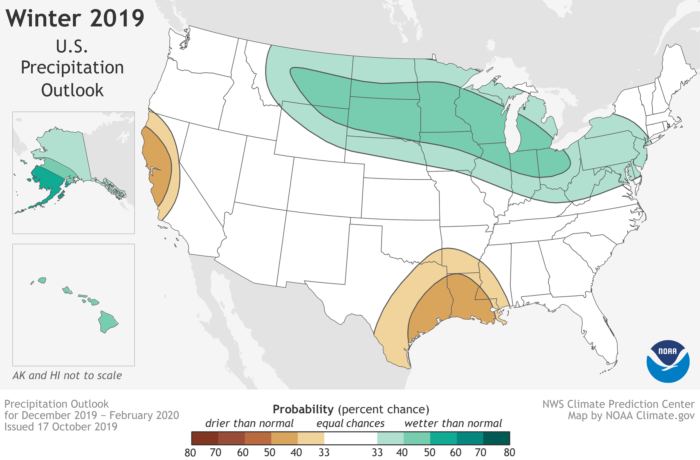
- NOAA: NOAA: Winter Outlook for 2019-20 Season | Above Average Temps, Average Precipitation
- Local meteorologist haha: VIDEO: Colorado Meteorologist Disagrees With Farmers’ Almanac | Here’s His Prediction…
For Canada see:
- Accuweather Canada: https://snowbrains.com/canada-winter-forecast-accuweather/
- Almanac: https://snowbrains.com/old-farmers-almanac-2019-20-forecast-for-canada-prepare-for-a-season-full-of-snow-snow-and-more-snow/
best article SB puts out every year.
now we just need one for japan and europe.