Stock image of autumn snow in the Rocky Mountains.
NOAA and many more weather outlets are pointing towards snow this week in the Rocky Mountains. Some are talking about up to a foot of new snow in the higher elevations.
Colorado, Utah, Montana, Idaho, Wyoming & B.C. are all expected to see snowfall this week with the bulk of the snow coming on Saturday.
Colorado may see snow as early as Tuesday.
ROCKY MOUNTAINS + B.C.:
The latest FGS snow forecast map. image: tom niziol facebook page
“Well snow lovers, the next chance for snow in the US will likely be going into the weekend where the higher mountains of the Rockies, from the Wasatch in Utah to the Absaroka and Beartooth in Wyoming will see a thin blanket of white. A large scale upper level Low will drop through the West and there will be enough cold air aloft to produce the snow.” – Tom Niziol/The Weather Channel
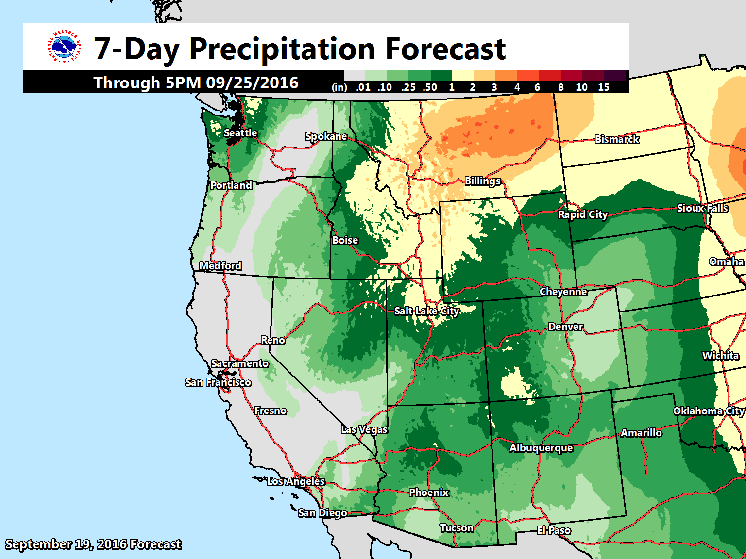
image: noaa, today
“Many western U.S. locations will see precipitation some time over the next 7 days. The area from northern Utah through eastern Idaho and into Montana will see the greatest amounts.” – noaa, today
image: noaa, today
“Big temperature swings coming to much of the western U.S. by mid week! This particular image shows the change in temperature between today and Friday.” – NOAA, today
MONTANA:
image: noaa, today
“We know there are still quite a few who venture into the backcountry during these early fall days, so if you or anyone you know is heading into the mountains this Wednesday through Friday: a very cold, wet storm system will bring snow levels to about 6000 feet along the Continental Divide, and will be combined with gusty winds. The threat for hypothermia, low visibility, and overall ugly and harsh conditions will be present. We’ll continue to update everyone through the week on this system!” – NOAA Missoula, MT today
image: noaa great falls, mt today
“Confidence in a significant precipitation event is increasing for later this week, mainly Wednesday through Saturday. The ingredients for this event will be an upper level low and moisture from Hurricane Paine (as seen on the satellite image). To be clear, Paine will weaken significantly as it moves into the southwestern US and will no longer be a tropical system as it’s remnant moisture moves further into the western US. However, some of that remnant moisture may get pulled north into Montana which could help enhance rainfall totals in some areas with the upcoming storm system. The evolution of both features will play a significant role in which areas see the higher rainfall totals, so please keep in mind that forecast amounts are subject to change” – NOAA Great Falls, MT today
UTAH:
image: noaa slc, ut today
“Are you ready for fall weather? After the summer-like temperatures to begin this week, it will be significantly cooler and wetter by the 2nd half of the week!” – NOAA SLC, UT today
COLORADO:
“The snowfall graphic below shows the snowfall possible Tuesday through Wednesday. The snow level may drop to around 12,000 ft MSL Tuesday night with 1-3 inches accumulation above that elevation. Again, there is the possibility of more snow Friday along with lower snow levels.” – NOAA Grand Junction, CO today
“A more significant storm system remains on track for Thursday (first day of Autumn) with the potential to bring widespread precipitation along with strong thunderstorms! Much cooler weather is then expected for Friday with mountain snow down to 8000-9000 feet mean sea level possible. Stay tuned as we continue to monitor this developing storm! ” – NOAA Grand Junction, CO today
“I have high confidence that we’ll see a storm from Thursday night through at least Saturday, and that this storm will bring cooler air with snow falling down to at least 10,000 feet.” – Joel Gratz/OpenSnow.com
IDAHO:
image: NOAA Pocatello, ID today
WYOMING:
This map shows the probability of seeing 2.5″ or so of snow or more on Saturday, September 24th, 2016. image: noaa, today
MORE:
6-10 day precipitation outlook showing above average precip for the Rocky Mountains. image: noaa, today6-10 day temperature outlook showing below average temps for the Rocky Mountains. image: noaa, today7-day precipitation outlook showing lots of precip for the Rocky Mountains – especially MT, ID, UT, CO, & WY. image: noaa, today“As mentioned yesterday, we are closely watching our next big weather system, which can be seen off the British Columbia coast in this morning’s water vapor image. The GFS and ECMWF computer forecasts are in better agreement this morning. They now suggest that the storm in the Pacific, which will move into the Pacific Northwest over the next couple of days, will split as it moves into the Rockies this coming weekend. Some of the energy will move through the Northern Rockies, while a secondary circulation will cut off over the Desert Southwest. This ‘split’ solution would explain why the ensembles yesterday were struggling with how far north or south the storm would track. If this morning’s solution ends up verifying, our area will see some windy conditions and possible high fire danger by the end of the week, followed by cooler and more unsettled weather. It remains to be seen how strong the low pressure system is and where exactly it tracks.” – NOAA Pueblo, CO today