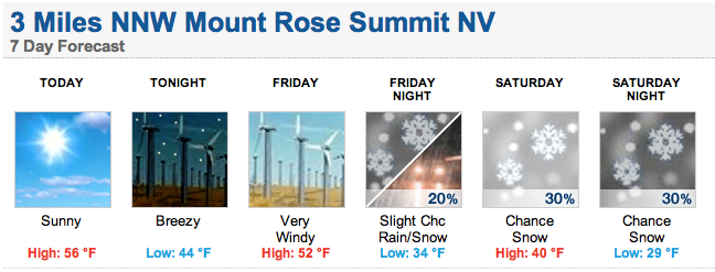
That’s right snow humans, snow is officially in NOAA’s Lake Tahoe forecast this weekend. It’s looking like the lowest snow levels will be around 8,000-feet. We’ll most likely only get a dusting, but it’ll be snow nonetheless.
If this pans out, this will be very first snow of the 203/14 winter and that is a beautiful thing. We’re strongly hoping for many many more snowfalls this winter.
It’s Tahoe’s turn to see a good winter. It our turn to shine.
SNOW LEVELS WILL DIP INTO THE 8000-8500 FOOT RANGE BEHIND THE FRONT SO SOMESNOW SHOWERS WILL BE POSSIBLE IN HIGH SIERRA. OVERNIGHT LOWS ON SATURDAY INTO SUNDAY MORNING WILL DIP INTO THE 20S FOR SOME SIERRA VALLEY LOCATIONS. – NOAA
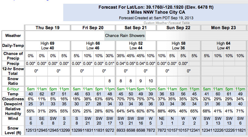
More Snow Next Week? NOAA thinks so:
HOWEVER THE COLD AIR IS STILL VERY APPARENT WITH THIS SYSTEM FOR MID WEEK,
WHICH MAY PUSH SNOW LEVELS DOWN TO 6000-7000 FEET AND COULD LIMIT
HIGHS TO THE 50S AND LOW 60S FOR WESTERN NEVADA WITH 40S FOR THE
SIERRA. OVERNIGHT LOWS MAY APPROACH FREEZING FOR THE OUTLYING AREAS
OF RENO-CARSON-DOUGLAS WITH LOW 20S FOR THE COLDER SIERRA VALLEYS
WEDNESDAY NIGHT AND THURSDAY MORNING. - NOAA
Related Posts:
Jah!
Frothing
Yessir!