Forecast By SnowBrains Meteorologist – Eric McNamee
11:40 AM MST, Nov. 23, 2020
Brought to you by Alta Ski Area
Forecast Summary:
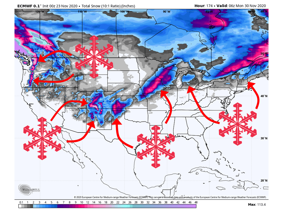
A series of storms will bring 1-3 FEET of snow over the western US this week, primarily in the Pacific NW and Colorado.
Troughing will continue over the Western US through Friday, allowing storms to move through the region.
Ridging and high pressure look to build over the West this weekend, allowing for colder storms in the Midwest and East Coast.
This looks to continue through the extended period of the forecast.
Short-Term Forecast:
Monday-Wednesday:
The first in a series of storms will move through the western US today and tomorrow, bringing 12-18″ of snow to the Colorado San Juan’s.
Only a couple of inches of snow is expected elsewhere in the west from this storm, with some higher amounts in the Cascades.
The second storm will move into the Pacific Northwest Tuesday evening, bringing 8-12″ of snow to the Cascades through Wednesday.
This same storm will move further inland heading into Thursday.
Long-Term Forecast:
Thursday-Sunday:
The last storm will make its way through the west Thursday and Friday, bringing an additional 2-4″ of snow to the majority of the Western US with locally higher amounts in the Cascades and Colorado Rockies.
New Mexico also looks to get snow from this system as well, mostly along the northern portion of the state.
This storm will then move east across the Midwest and Eastern US this weekend.
Snowfall amounts are not certain at this time, but decent snow accumulations are possible for the Midwest and higher elevations of the East Coast.
Extended Forecast:
Friday and Beyond:
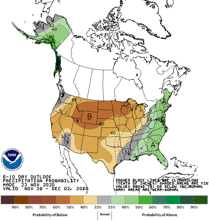
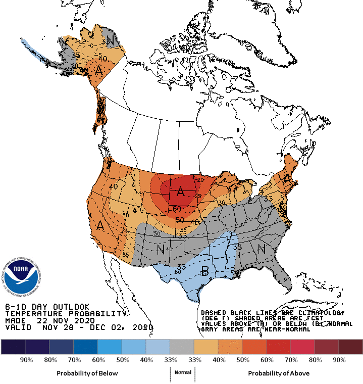
Global ensembles indicate a pattern shift will take place heading into this weekend, with troughing that has been over the Western US the last couple of weeks moving to the east.
This means warmer temperatures and drier conditions are likely to develop over the west heading into the weekend.
Colder temperatures and wetter conditions are expected to develop over the eastern half of the US.
Utah:
Like Colorado, Utah will stay dry through the short-term with a ridge of high pressure over the state.
Resorts that look to be favored are Alta, Snowbird, Brighton, Solitude, Park City, Canyons, Deer Valley, Brianhead, and Wolf Creek.
**Alta Forecast**
A couple of weak storms will make their way through Northern Utah, bringing 3-6″ of light snow over the next week.
The first storm will move through today and tomorrow, bringing mostly flurries to the area and an inch or two for the Central Wasatch.
The second storm will move through Wednesday night, into Thursday morning.
This storm looks to have a little more juice to it, but will still only bring 2-5″ of snow to Alta.
Conditions look to dry out heading into the weekend as high pressure builds over the Western US.
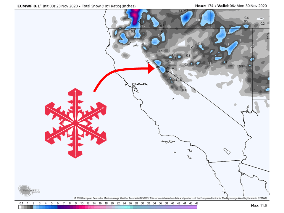
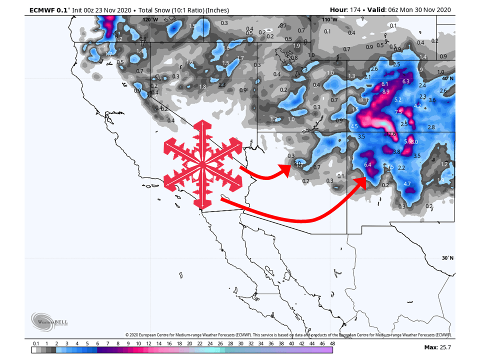
California:
California will stay relatively dry this week, with, 2-5″ of snow possible around Tahoe as the storm track stays primarily to the North.
Resorts likely to get the most snow are Boreal, Kirkwood, Sugar Bowl, Squaw, Alpine, Northstar, Homewood, and Heavenly.
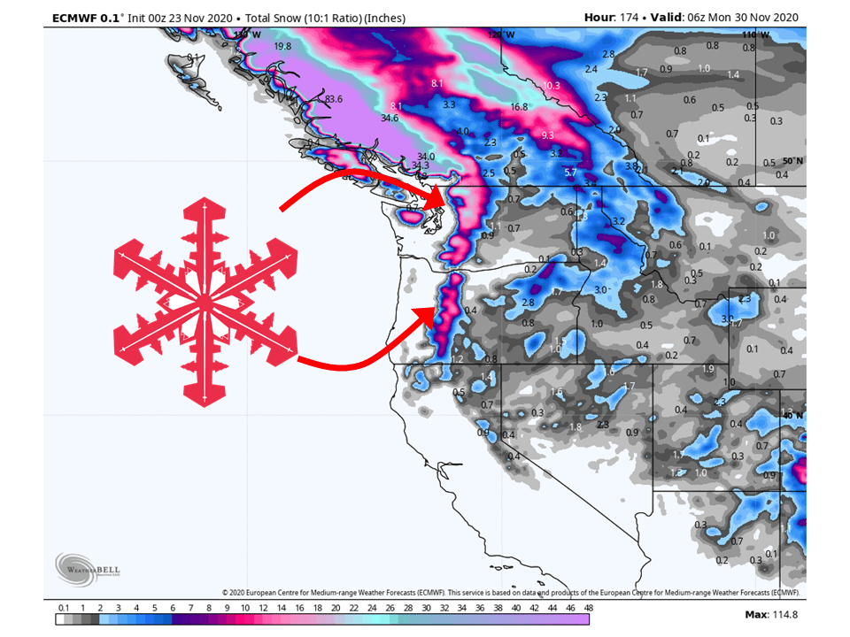
Pacific Northwest:
The Pacific Northwest looks to fair pretty well with 1-3 FEET falling through the next seven days.
This will come in a couple of waves, with the first moving through today and the second on Wednesday.
The storm on Wednesday will drop 8-14″ of snow across the Cascades, with some locally higher amounts possible.
An additional wave of snow will come later this week.
Resorts that look to see the most snow are Mt. Bachelor Timberline Lodge, Crystal Mountain, Alpental, and Mt Baker.
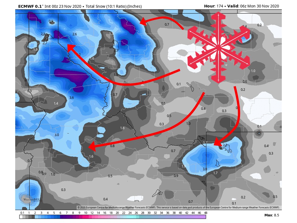
Northern Rockies:
The Northern Rockies will see relatively light snowfall amounts, with 6-10″ of snow falling through the next week.
The highest amounts will be along the Bitter Roots Range and Lewis Ranges
Resorts that look to see the most snow are Jackson Hole, Targhee, Big Sky, Big Moutain, and Schweitzer.
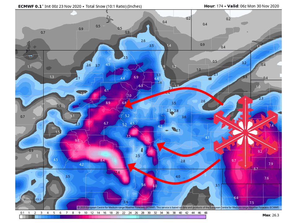
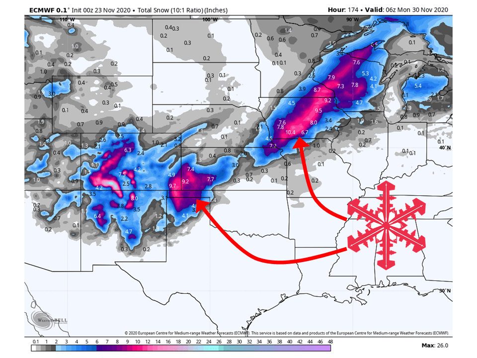
Colorado:
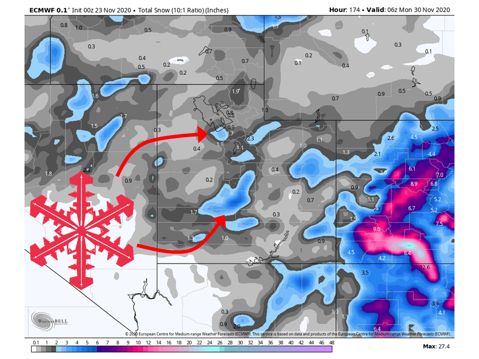
The San Juan Mountains look to get pounded with 1-2 FFET of snow through Wednesday as extremely moist flow slams into the range.
Snowfall amounts outside of the San Juan Mountains will still be good, with 8-14″ falling elsewhere.
An additional couple of inches is possible later in the week as well.
Resorts that look to see the most snow are Aspen, Steamboat, Wolf Creek, and Winter Park.
Southwest:
New Mexico will see snow through the day tomorrow as portions of the Sangre de Cristo Mountains and Souther Sane Juans see 8-14″ of snow.
Arizona will see snow as well, but not as much as New Mexico due to the main moisture transport being east of Arizona.
Taos Ski Resort in New Mexico will likely see the most snowfall.
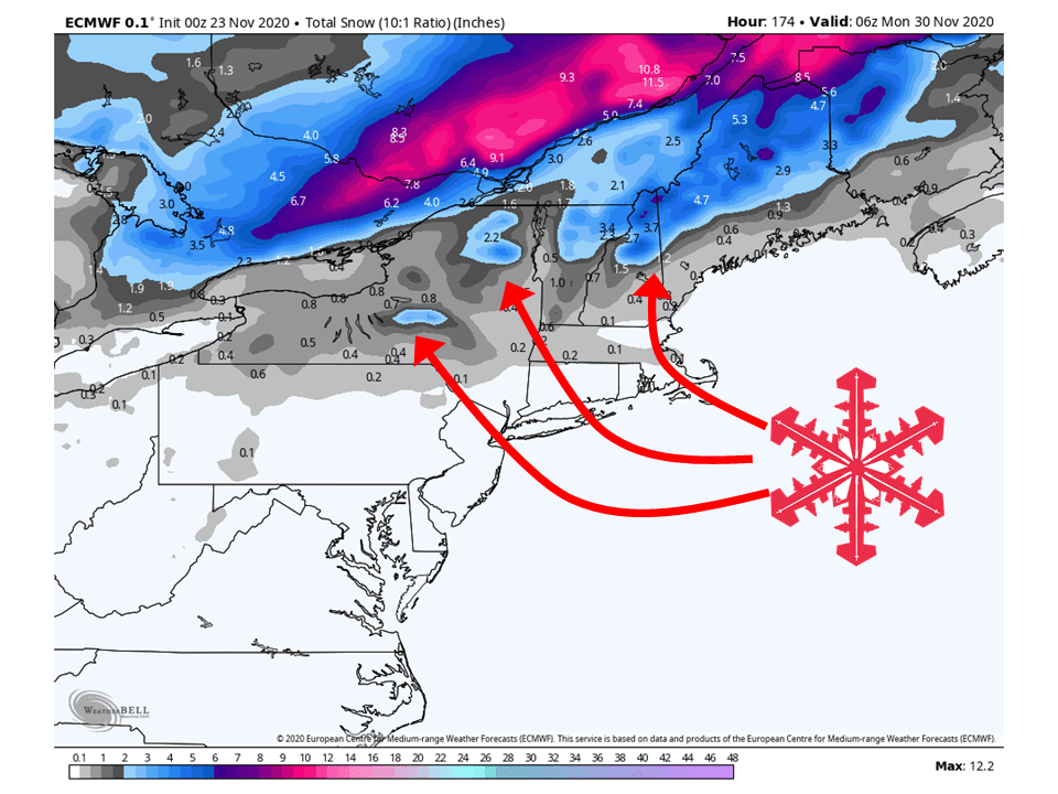
East Coast:
The first wave of snow will blanket the higher elevations of the Northeast Wednesday and Thursday, with 1-3″ of snow falling in high elevations.
Additional light snowfall is possible heading into the weekend as another storm moves into the Eastern US.
Resorts likely to see the most snow are Loon, Killington, Jay Peak, Mad River Glen, Sunday River, and Whiteface.
Midwest:
The Midwest will stay mostly snow-free through Friday with high-pressure overhead.
However, this weekend a pattern shift looks to take place.
This has the possibility of bringing high snowfall amounts to the upper Midwest.
USA:
Global Ensembles show a pattern shift will take place later this week.
Troughing in the West will move over the Eastern US and high pressure will build over the Western US.
This will translate to warmer temperatures with below-average precipitation in the West and slightly above-average temperatures in the East with above-average precipitation.