Forecast By SnowBrains Meteorologist – Eric McNamee
Brought to you by Alta Ski Area
11:50 AM MST, 12/16/2020
Forecast Summary:
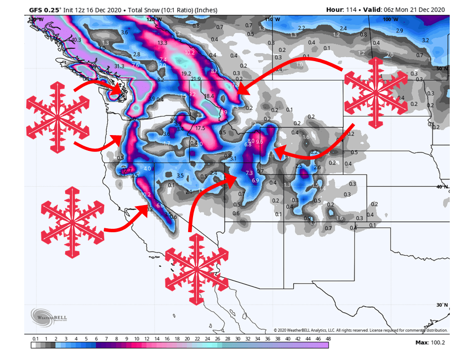
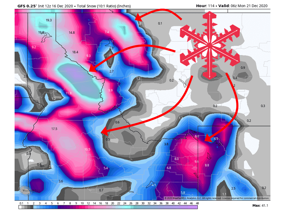
1-4 FEET of snow is expected across the West through the weekend as a series of storms make their way through the region.
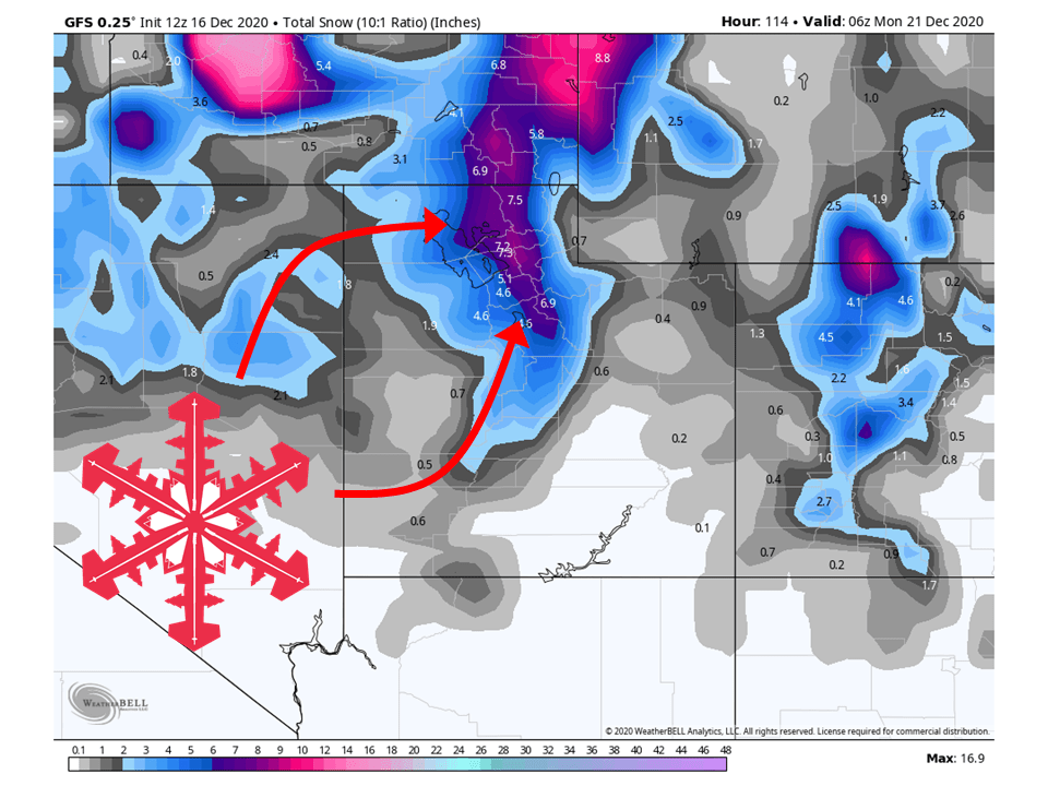
This will bring some relief to California and Utah as 12-16″ and 8-14″ of snow are expected in the mountains respectively.
The Pacific Northwest and Northern Rockies look to be the winners as 2-4 FEET of snow is expected across the two regions.
Conditions look to dry out heading into next week and beyond.
Short-Term Forecast:
Wednesday-Friday:
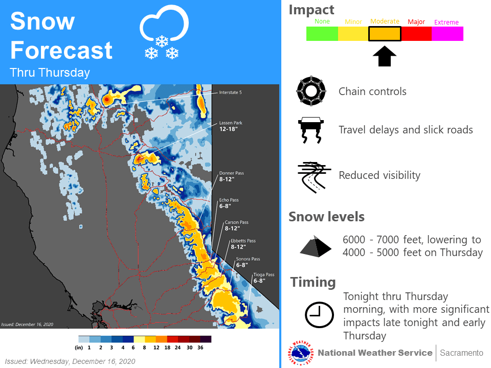
A shortwave trough moving into the West Coast today will get things going in the Cascades and Sierra’s where 8-16″ of snow is expected to fall in the two mountain ranges through Thursday.
This same shortwave will move inland during the day Thursday bring 8-16″ of snow to portions of the Northern Rockies and Northern Utah through Friday.
The next shortwave looks to move into the West Coast later in the day Friday, bringing the next chance for snow.
Long-Term Forecast:
Saturday-Tuesday:
This next shortwave will start by bringing an additional 1-2 FEET of snow to the Pacific Northwest and Northern Rockies.
This same shortwave will drop 2-4” of snow across the Wasatch in Northern Utah through Sunday.
California looks to remain dry during the long-term.
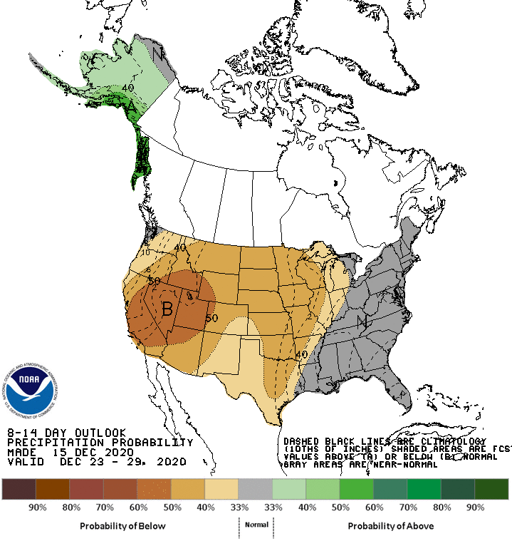
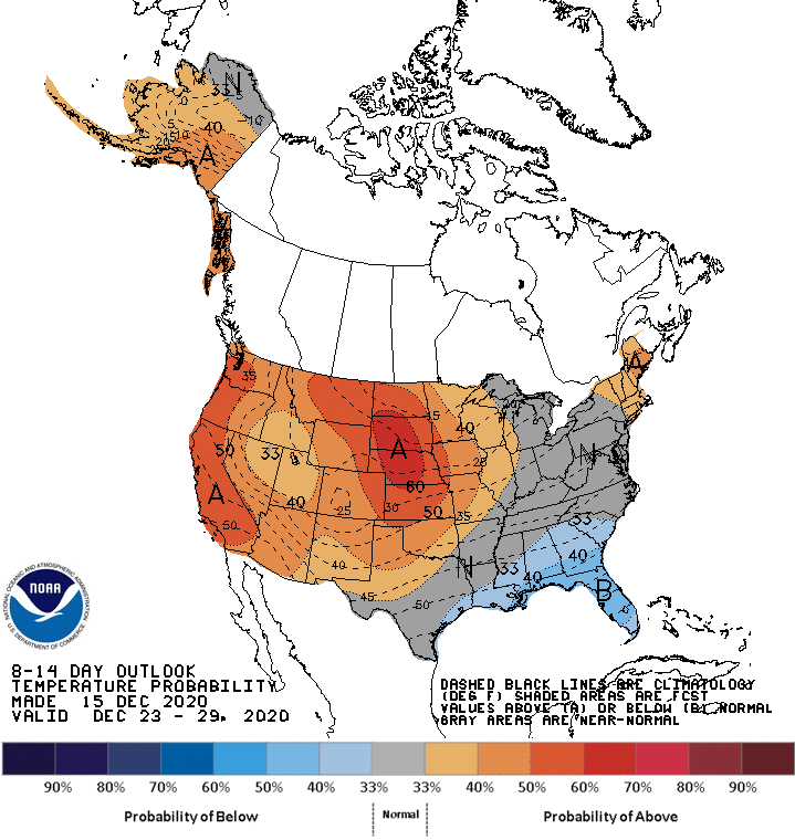
Extended Forecast:
Wednesday and Beyond:
Global ensembles are indicating the pattern will dry out again as another ridge of high pressure builds over the west.
This will result in above-average temperatures and below-average precipitation across the West in the extended.
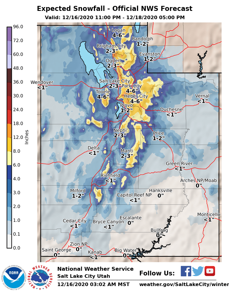
Utah:
The first of two shortwaves will move through the state Thursday/Friday, bringing 8-14″ snow to the Wasatch.
Another shortwave will brush by the state this weekend, bringing 2-4″ of snow to the northern part of the state..
Resorts that look to be favored are Alta, Snowbird, Brighton, Solitude, Park City, Canyons, Deer Valley, Snowbasin, Powder Mountain, and Beaver Mountain.
**Alta Forecast**
Snow looks to start Thursday morning for Alta and last through the day Friday, bringing 8-14″ snow with possibly more under northwest flow.
Another shortwave will brush by this weekend, bringing an additional 1-3″ of snow to the mountain through Sunday.
A general drying trend is expected getting into next week.
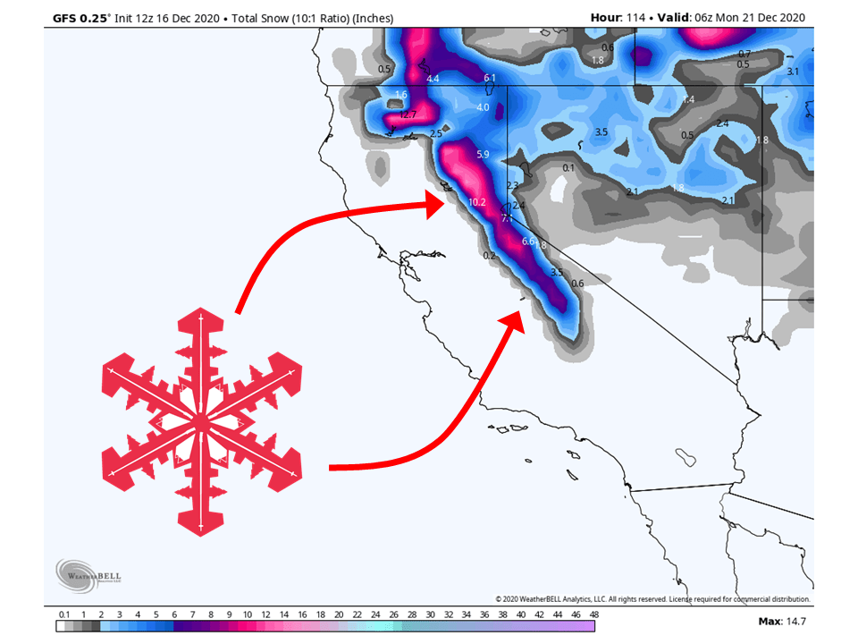
California:
The Sierra’s will see 8-14″ of snow through Friday morning as the first shortwave moves into the west.
The second shortwave looks to stay to the north this weekend, missing the state in total.
Resorts likely to get the most snow are Boreal, Kirkwood, Sugar Bowl, Squaw, Alpine, Northstar, Homewood, and Heavenly.
Pacific Northwest:
The Pacific Northwest looks to fair pretty well with 1-4 FEET falling through the weekend.
The first shortwave will move through Thursday, bring 8-16″ of snow to the Cascades through Friday morning.
The second shortwave will move through the weekend, bringing an additional 1-2 FEET of snow to the region.
There’s a chance for some additional snowfall in the middle of next week, but the overall pattern looks dry.
Resorts that look to see the most snow are Mt. Bachelor, Mt. Hood, Timberline Lodge, Crystal Mountain, Alpental, and Mt Baker.
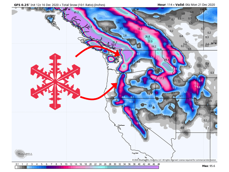
Northern Rockies:
Like the Pacific Northwest, the Northern Rockies will fair pretty well through the weekend with 2-4 FEET of snow falling through the weekend.
This will start with the first shortwave trough bringing 8-14″ of snow to portions of the region.
The second shortwave looks to bring more snow as an additional 1-2 FEET is expected through the weekend.
A general drying trend is expected next week.
Resorts that look to see the most snow are Jackson Hole, Targhee, Big Sky, Whitefish Mountain, and Schweitzer.
USA:
Global ensembles are indicting conditions will dry out next week ridge of high pressure builds over the Western US next week.
This means above-average temperatures and below-average precipitation is expected through the extended period of the forecast.