Forecast By SnowBrains Meteorologist – Eric McNamee
3:40 PM MST, 4/20/2021
Forecast Summary:
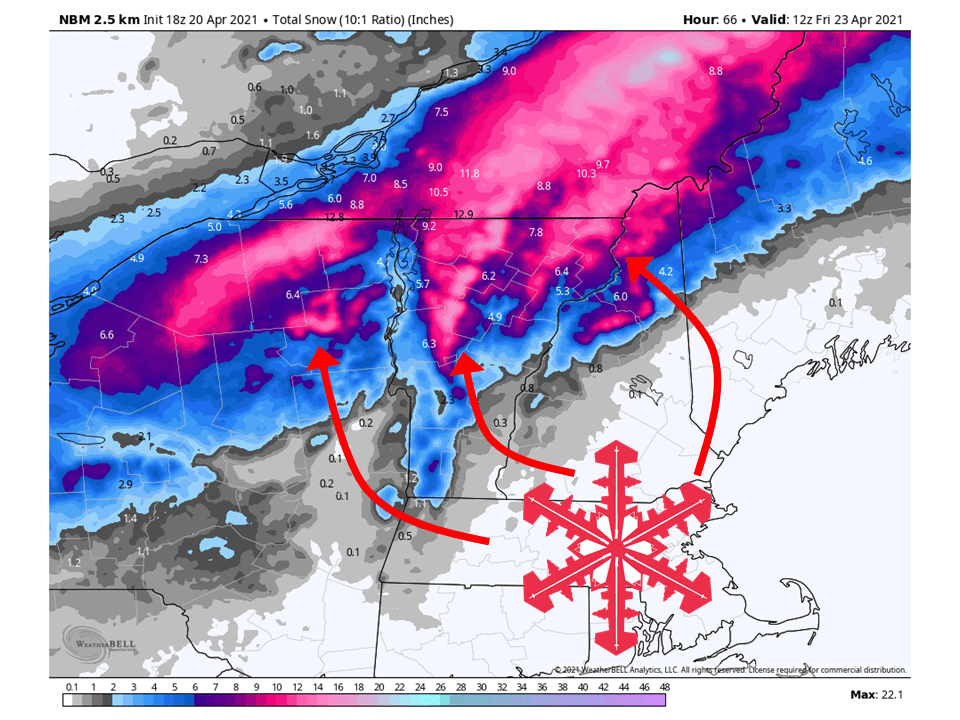
A dynamic system will move through the Northeast today through Thursday and bring 6-12″ of snow to parts of Northern Vermont and New York.
Precipitation will begin tonight as rain and snow for most locations before turning over to all snow tomorrow night.
Precipitation will then become showery Thursday and be mostly confined to higher elevations Friday morning.
Resorts that look to see the most snow are White Face, Stowe, Jay Peak, Sugarbush, and Bolton Valley.
Short-Term Forecast:
Tuesday-Thursday:
A system will move through the Northeast today through Thursday and bring 3-8″ of snow to parts of Northern Vermont and New York.
Precipitation will start tonight as rain and snow for most locations across the region, with some light sleet accumulations as well.
Precipitation will then pick up in intensity tomorrow afternoon as moisture streams into the area.
By tomorrow night, all precipitation will change over to snow as the cold front moves through the region.
A strong northwest flow is expected behind the front and will keep some snow showers around, mostly confined to higher elevations.
Snowfall amounts will likely be lower than the map above but the map does a good job at visualizing where the heaviest snow will be.
Winter Weather Advisories have been issued for parts of the region because of this.
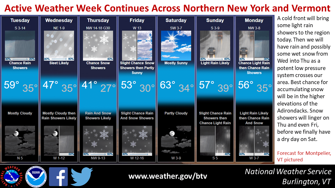
A multi-faceted storm will approach the forecast area beginning late
tonight. Precipitation will begin as a mix of rain and snow, with
trace amounts of sleet possible. Rain and snow will continue
throughout the day tomorrow, with wet snow accumulating across
the Adirondacks and northern Green Mountains. Precipitation will
be heavy during the afternoon and evening. After 8 PM
Wednesday, precipitation will change to snow across the entire
forecast area as a cold front exits east. Strong northwest
winds are expected on Thursday in addition to lingering mountain snow
showers and below normal temperatures. Additional chances for
precipitation are expected for the end of the week, though
temperatures will return to near normal.
-NWS Burlington 4/20/2021
Long-Term Forecast:
Friday-Monday:
Snow will taper off completely by Friday morning as the system moves off to the east.
Conditions will then temporarily dry out Saturday before Precipitation moves into the region Sunday and Monday.
Extended Forecast:
Monday and Beyond:
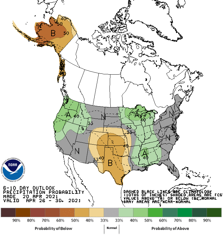
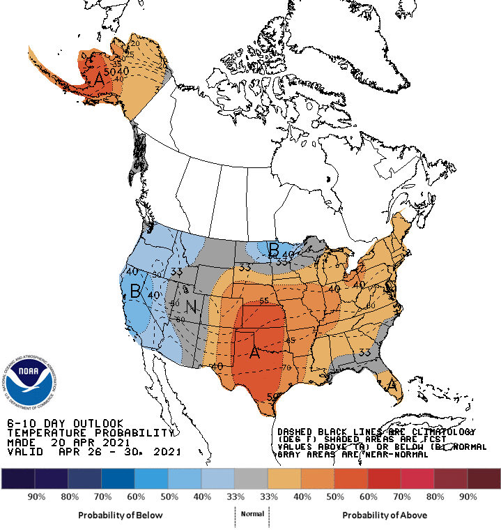
Global ensembles are indicating average precipitation and above-average temperatures across the region.