Forecast By SnowBrains Meteorologist – Eric McNamee
10:40 AM MST, 4/12/2021
Forecast Summary:
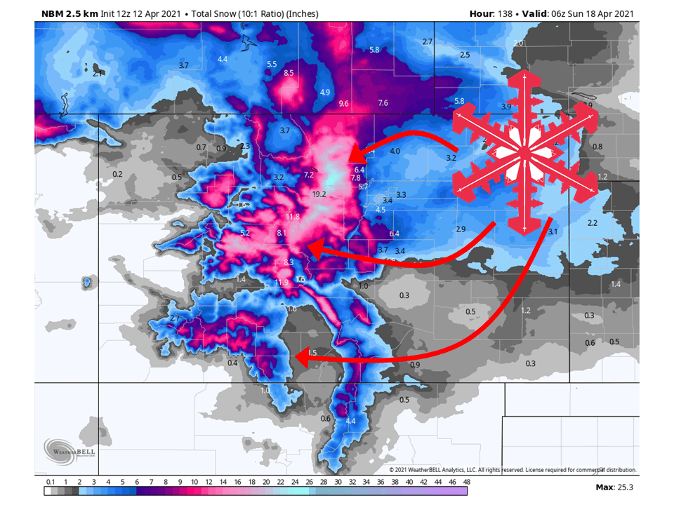
A brush-by system and a closed low will develop this week over the Great Basin and bring 6-24″ of snow to the mountains of Colorado.
A system will brush by the area tonight and tomorrow, bringing the first round of snow to the state, mostly confined to the northern front range.
The next round of snow will come Thursday through Friday from the closed low over the Great Basin.
This closed low will bring the bulk of the snow to the state.
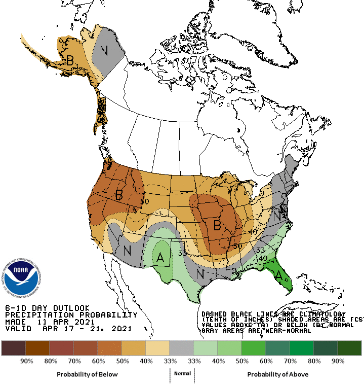
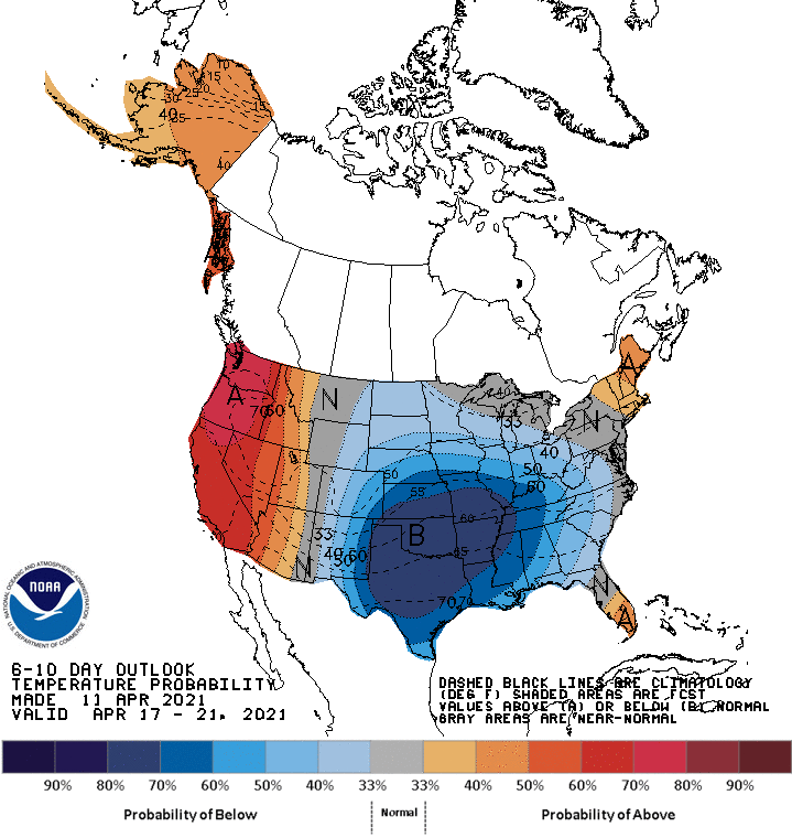
Below-average temperatures and about average precipitation are expected in the extended.
Resorts that look to see the most snow are Aspen, Vail, Arapahoe Basin, Keystone, Copper Moutain, Breckenridge, and Winter Park.
Short-Term Forecast:
Monday-Wednesday:
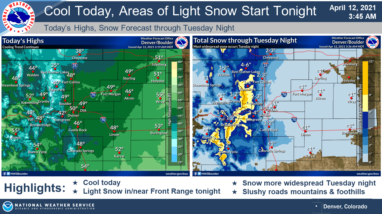
The first round of snow will fall late tonight through tomorrow, bringing 4-12″ of snow to the front range.
Snow will get going tonight and taper off a bit during the day Tuesday.
A lot of instability will be around so moderate snow showers will redevelop Tuesday afternoon and night.
Light snow showers will be ongoing Tuesday morning across the
mountains, foothills, and western I-25 corridor due to weak upper
level lift along with low level upslope flow. These snow showers
should diminish through the morning hours as slight ridging
develops between a trough over Wisconsin and another trough over
NW Nevada. The partial clearing in the mountains will allow for
decent instability to build in. As the trough over Nevada slowly
moves eastward, it will produce better QG ascent across our
forecast area late Tuesday afternoon and through Tuesday night.
This combination of instability and lift will lead to the
development of moderate snow showers over the mountains and
foothills Tuesday afternoon that eventually make their way onto
the plains later Tuesday evening. Snow amounts in the mountains
and foothills will be roughly between 3 to 8 inches with lower
amounts in the parks and valleys and potentially higher amounts
across mountain peaks and ridges. The I-25 corridor is expected to
see up to 2 inches by Wednesday morning with up to an inch across
the eastern plains. While the snow may initially melt on pavement
Tuesday afternoon, the temperatures should be cold enough for
snow accumulation on roads in the mountains and foothills Tuesday
night. This may require a Winter Weather Advisory but there is
enough uncertainty in the travel impacts to not issue any
highlights at the moment.
-NWS Boulder 4/12/2021
Long-Term Forecast:
Wednesday-Sunday:
Things really get going in the long-term as the closed low over the Great Basin brings the bulk of the snow to Colorado.
Snow will get started Thursday night as the center of the low starts to move into Colorado.
The exact track of this low is still a bit uncertain but if it were to move into the southern part of the state, decent snow totals would be possible.
Snow showers will likely continue through Saturday as the trough moves off to the east.
The main event for this cool and unsettled pattern appears to be
Thursday night through Friday as the trough moves across Colorado.
If the trough and associated surface low pressure center were to
move across southern Colorado, there would appear to be potential
for snow amounts to be above Winter Storm Warning criteria. If the
system were to track through northern Colorado or northern New
Mexico, values would be less. It`s too early to speculate about
the exact track but PoPs are around 70 percent Thursday night
indicating confidence that there should be a good period of
precipitation.
-NWS Boulder 4/12/2021
Extended Forecast:
Sunday and Beyond:
Global ensembles are indicating average precipitation and below-average temperatures across the region.