Forecast By SnowBrains Meteorologist Nathan Tarino
Last Updated 6 PM MST Sunday 4/17
Forecast Summary
A late season snowstorm is set to bring solid accumulations to the high elevations across the east on Monday night and Tuesday morning. The best snow will be found in the higher terrain of Pennsylvania and New York, while resorts in Vermont and New Hampshire could deal with rain mixing in at times.
Quite a few of the resorts that will benefit the most from this system have already shut down winter operations for the year, which is unideal. However, a lucky few have held out and should offer up some great turns on Tuesday.
The forecast for Vermont and New Hampshire remains very uncertain. The exact track of the low will determine if the Greens and Whites see predominantly snow or rain.
Short Term
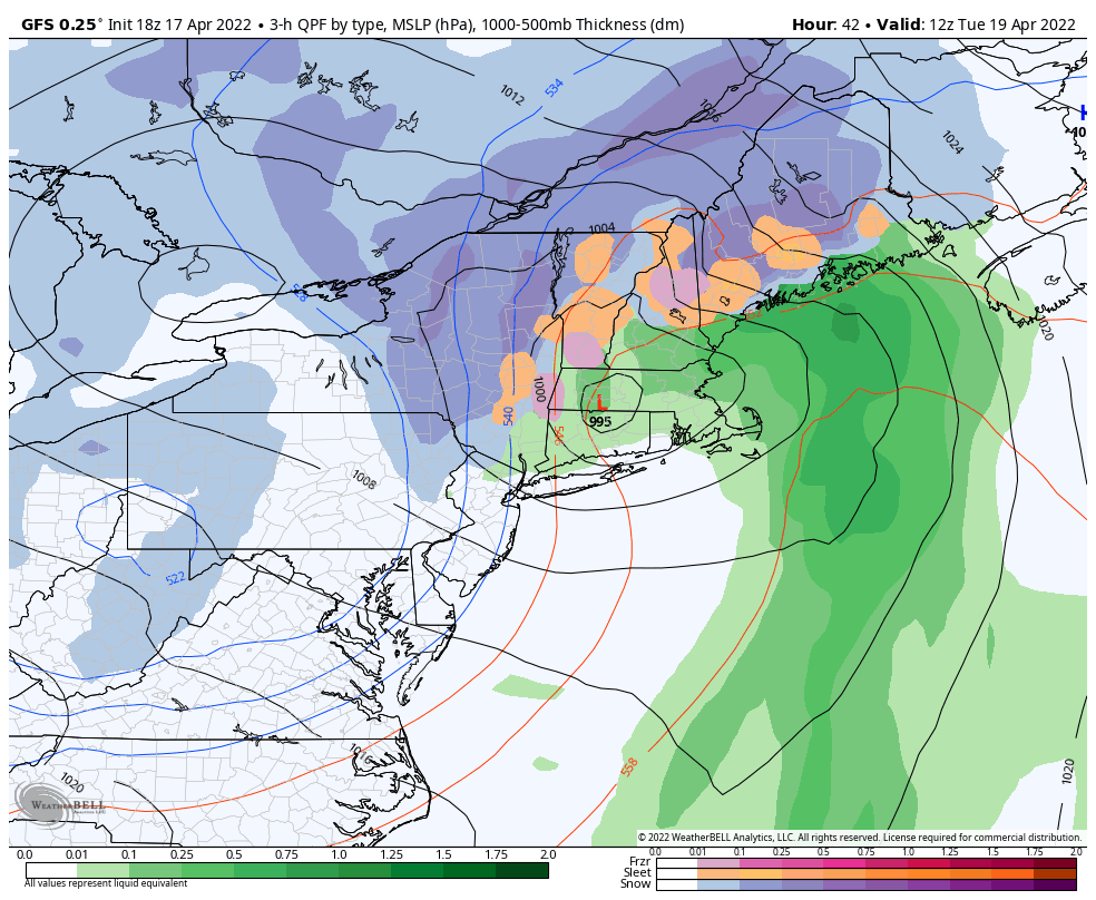
An upper level disturbance currently bringing snow to the Dakotas will dive into the Northeast by Monday night. Low pressure will develop at the surface in the DelMarVa by Monday evening and track northward up the I-95 corridor overnight. Snow will fall in the high terrain west of the low’s track, while rain will be prevalent on the eastern side.
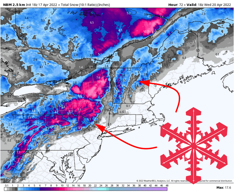
Heavy snowfall will begin in the Appalachians in West Virginia by mid afternoon Monday and push into the higher terrain of Pennsylvania by Monday evening. Particularly heavy snow will fall overnight in the Adirondacks, and much of western New York as well. It remains unclear how much snow the Catskills, Greens, and White mountains will get from this storm as they’re very close to the rain/snow line.
To illustrate this uncertainty, check this out – below is a map of precipitation type, snow in blue, rain in green, and a wintry mix in yellow and pink. Cold air will tend to stay on the west side of the low pressure (located here in central Jersey), and you can see how snow is confined generally to the inland side of the low’s center.
That much is more or less a guarantee. What remains to be seen is the exact track the low will take through New England. Below is ensemble output, a tool used to show the range of possible outcomes in situations where the forecast is uncertain. What you’re seeing is all of the different places the low might be by Tuesday morning, denoted by the little Ls.
Each of the little Ls below represents a possible outcome, each with snow on the west side of the low and rain on the east. You can see how a different low track would make the difference between rain and snow in Vermont and New Hampshire.
The forecast could realistically trend much snowier in these areas as well as much rainier, and we’ll just need to wait to see if it does.
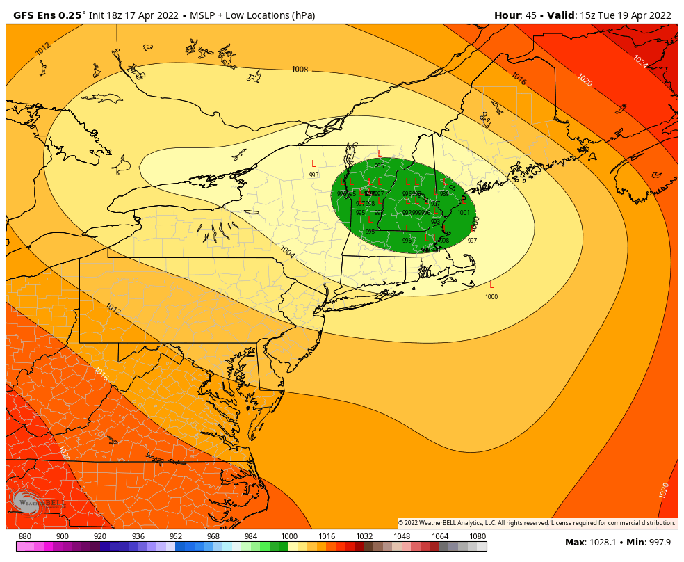
A more westerly track will mean rain for Vermont and New Hampshire, but a jog to the east would bring appreciable accumulations, especially in Vermont. I’ll update the snow totals in this forecast again Monday afternoon to reflect any forecast changes.
Regardless of forecast trends, Whiteface is my pick for pow turns on Tuesday morning. It’s the only resort that’s still open that I’m confident will see quality snow.
For now, expect the following accumulations by midday Tuesday:
- 3-6″ the Apps from West Virginia into Pennsylvania
- 7-13″ in the highest terrain in the Adirondacks (Whiteface is still open this week!)
- 4-7″ in the Catskills
- 2-5″ in the Greens and 1-3″ in the Whites with a chance for much more should the low track trend east
- 1-3″ in the high terrain of Maine, again with a chance for more with an eastward trend
Long Range
It’s mid April. This is probably the last good shot of snow of the season. Savor it!
Le Valinouet QC has received 913 cm of snow so far – which may be a new all-time record for Eastern Canada
I usually focus south of the international border but they’ve been getting hammered in QC this winter! 913 cm is pretty insane for anywhere east of the Mississippi.