Forecast written by Clay Malott – 10pm PST 2/25/23.
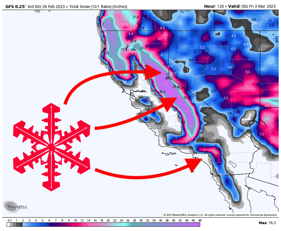
After a system just dropped 60″ on Tahoe resorts (and 100+ in SoCal), California will get another massive storm this week, dropping as much as 6+ FEET on resorts. The storm will start on Sunday afternoon and last through Tuesday night. The best day of skiing will be on Tuesday, but Monday and Wednesday will also be legendary days. The most favored resorts will be Palisades Tahoe, Sugar Bowl, Kirkwood, and Bear Valley.
The first wave of snow hits on Sunday afternoon, dropping a few inches of fresh snow during the ski day. On Sunday night, here are what I see as reasonable totals:
- West Tahoe basin (Palisades, Sugar Bowl, Kirkwood): 6-10″
- Central Tahoe basin (Northstar, Homewood): 3-6″
- East Tahoe basin (Mt. Rose, Heavenly): 1-3″
- Mammoth: 1-3″
Snowfall rates will increase during the day on Monday, bringing 9-15″ of new snow to resorts in the west Tahoe basin. Central and eastern resorts will see 5-10″ during the day, ensuring conditions stay fresh all day.
Tuesday could be one of the best days of Tahoe skiing in recent memory. A combination of cold temperatures, bountiful moisture, and optimal wind will make for DEEP conditions with unusually light and fluffy snow. Here’s what I see as conservative totals on Tuesday (Monday night totals + snow during the ski day on Tuesday). The models are still split on this leg of the storm, so it could realistically end up on either end of these scales; however, I’m feeling pretty optimistic as the model trend has been moving in the right direction.
- West Tahoe basin: 20-35″ (highest totals at Kirkwood)
- Central Tahoe basin: 12-20″
- East Tahoe basin: 10-15″
- Mammoth: 15-20″
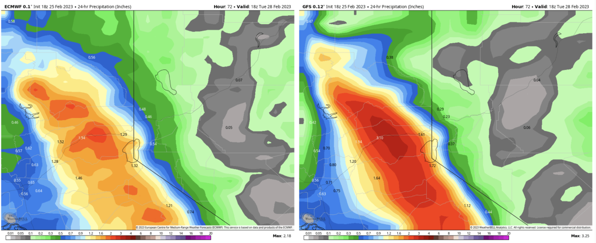
I would not be surprised if totals exceed the numbers above, but below is the reason that there’s still so much uncertainty in the forecast. On the left is the European model and on the right is the American GFS. The GFS is much more aggressive with precipitation on Monday night than the ECMWF. I have a feeling the Euro will eventually trend toward slightly higher totals, but not quite as much as the GFS currently has.
Snowfall rates will gradually decrease on Tuesday night, but Wednesday will still see excellent conditions. Here are my forecasted overnight totals by the time lifts start spinning on Wednesday:
- West Tahoe basin: 10-18″
- Central Tahoe basin: 6-12″
- East Tahoe basin: 6-9″
- Mammoth: 8-12″
Wednesday morning will bring some showers but not much accumulation.
Models are indicating another storm system this weekend, starting on Saturday night. The details about the magnitude of this system remain fuzzy, but it doesn’t look as strong as this week’s two storms. Some models have storminess lingering all of next week, so next week could further sweeten Tahoe’s already legendary season.
2 thoughts on “SnowBrains Forecast: California to get HAMMERED This Week With 6+ FEET Expected”