Forecast by SnowBrains Meteorologist Nathan Tarino
Most Recently Updated 1 am MST February 21st
Forecast Summary
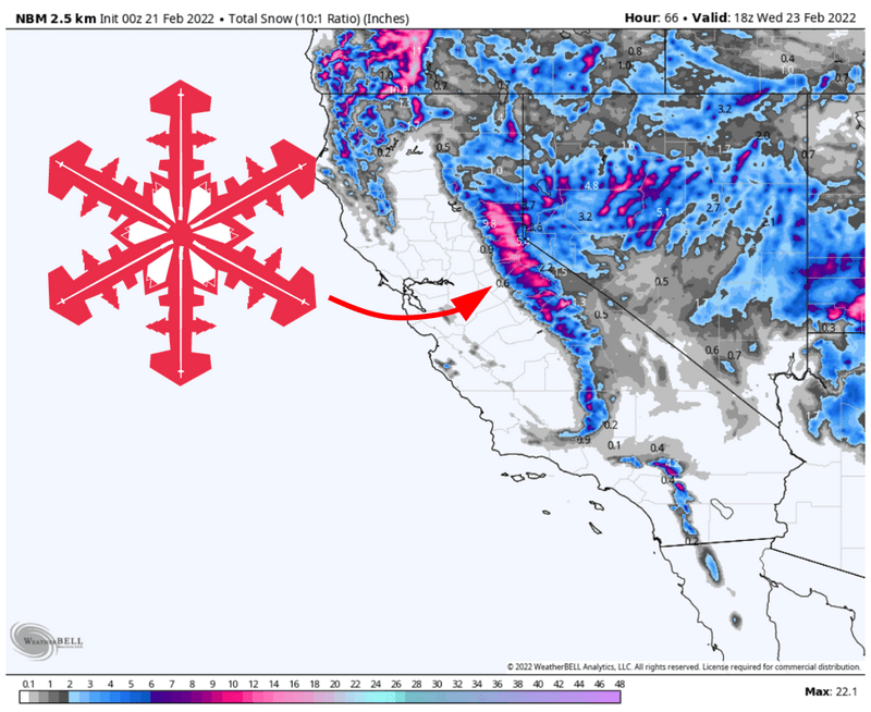
After UC Berkley’s Central Sierra Snow Lab recorded a record-setting 37-day dry streak, snow is finally headed for the Sierras. Snow will fall Monday night and into Tuesday, with the best ski conditions on Tuesday morning.
The heaviest snow will fall near Lake Tahoe. Lesser but still appreciable totals will fall farther south near Mammoth. Layer up as fresh snow will be accompanied by some very chilly air.
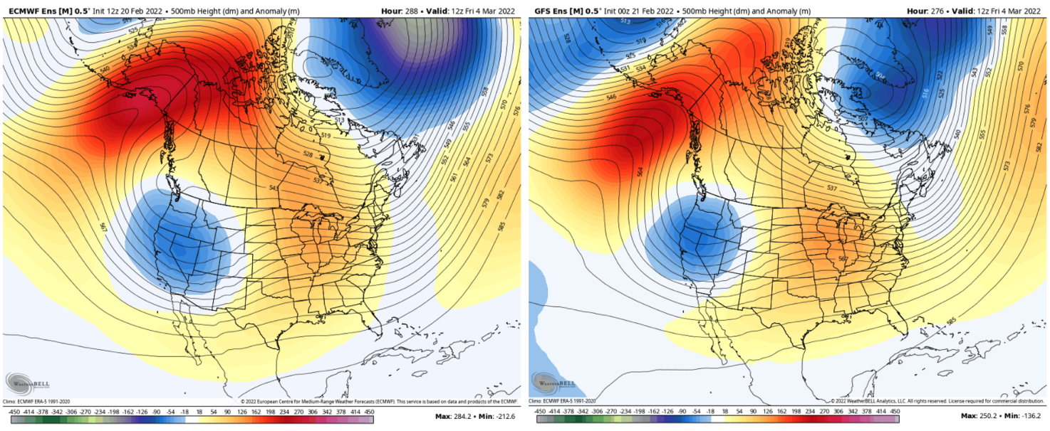
While forecast confidence remains low, there is some hope in the long-range forecast. Ensembles suggest a mean trough may develop over the American West in the first week of March – a pattern that would bring more snow to Californian ski resorts.
Short Range
A few snow showers will fall over the Northern Sierra Nevada Sunday night into Monday morning. Accumulations will be pretty light, with 1-3″ of snow possible near and north of Lake Tahoe. The main event doesn’t start until Monday night, but every inch counts after such a dry streak.
Heavier snow will move into the Tahoe area Monday night. The heaviest snow will fall overnight, with showery snow lingering into Tuesday evening. By the time the storm moves out on Tuesday night, I expect 7-13″ of snow for resorts in the vicinity of Lake Tahoe. Some of the typically snowier mountains (Kirkwood, Sugar Bowl) could see locally higher totals, perhaps pushing the 15″ mark. Ski conditions should be excellent all day on Tuesday.
Down south in Mammoth, snow will begin falling Tuesday morning. Expect dust on crust to start the day, but steady accumulations through the afternoon should make for decent skiing before the last chair. I expect 3-5″ of snow on the mountain by late Tuesday night, most falling before the resort closes on Tuesday.
There is a ton of cold air with this storm. Mountain temperatures will fall into the teens on Monday, and Tuesday and Wednesday morning lows in the single digits are likely. Bundle up if you’re getting after it.
Long Range
There is cause for cautious optimism in the long-range forecast. Both the American and European ensembles show a pretty strong signal that some type of trough will develop over the Western US in the first week of March, the kind of pattern that can produce significant snowfall in the Sierra.
Now, this is at really long lead times and at the end of the window in which I trust model guidance at all. I typically wouldn’t include something so far off in a forecast. However, guidance has been remarkably consistent over the past few days, painting a trough over the West Coast.
So something to monitor, for now. Time will tell if this feature will develop as modeled and bring any snow.
A very well known weatherman once told me, it’s very difficult to predict precipitation amounts on the west coast. There are thousands of miles of open ocean out there with very few ways to actually tell what’s going on. Where as once you start heading east, the weathermen can collect the data from sources along the way that the storm has already passed over. We can predict all we want, but your guess is about as good as these actual weathermen.