Forecast By SnowBrains Junior Meteorologist – Clay Malott
5:50 PM MST, 11/19/2021
Extended forecast
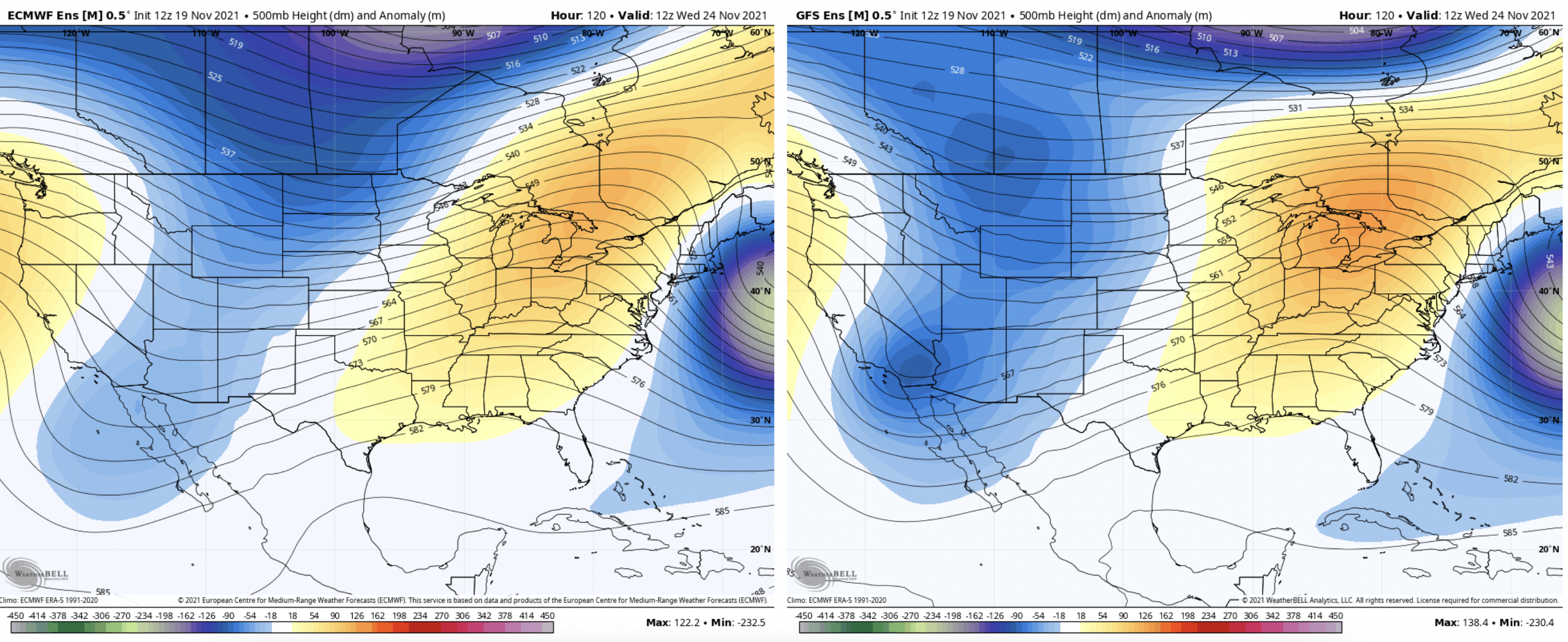
Things are looking good for a strong pattern to move in next week. A “white Thanksgiving” is fairly likely, with most of the models agreeing on Wednesday and Thursday to be the most probable storm timing! Below is the European (left) and American (right) ensemble forecasts:
Summary
This weekend, a minor storm will push through Colorado, bringing moderate accumulations to northern Colorado with smaller totals further south. The highest totals will accumulate in the northern region of the state near Steamboat, with accumulations of at least 2-3″ in the mountains and at least an inch in the valleys everywhere north of Aspen. The upper Park Mountains near Steamboat and the highest peaks along the Continental Divide will see 5-8″ with maximums of as much as 12-16″. However, most ski resorts in those areas will still only see 3-5″ by Saturday night. A second, bigger storm will push through the state on Wednesday and Thursday of next week.
The storm just passed through the Pacific Northwest last night, bringing some pretty respectable totals to the mountains there. The moisture is now bearing down on Colorado from the west-northwest. The first flakes should begin to fall near Steamboat around 4 or 5 am on Saturday.
The snow will then gradually begin to push south. Here, the forecast gets a bit tricky, as the models are all over the place. Some models have more upper-level dynamics producing the precipitation; if this is the case, precipitation will continue further south and bring light snow to the central and southern mountains. If orographic forcing alone is producing most of the precipitation, totals will pile up in the north and stay drier in the south.
I think the first scenario will pan out, and the southern mountains could get some action, but keep in mind it could realistically go either way. Nothing much, but a good chance as 1-3″ in the San Juans and Sawatch Mountains. The central mountains near Aspen could go for 3-4″.
While and after the main wave of storm energy passes through the region, westerly winds in the north will force saturated lower-level air up and over the mountains, generating respectable snow for the Park Mountains near Steamboat and the Northern and Central Front Range. Totals in these areas will most likely climb above 1 foot in the highest regions, but more widespread totals of 5-7″ are more likely. However, most resorts in the northern area of the state should see 3-4″ by Saturday night.
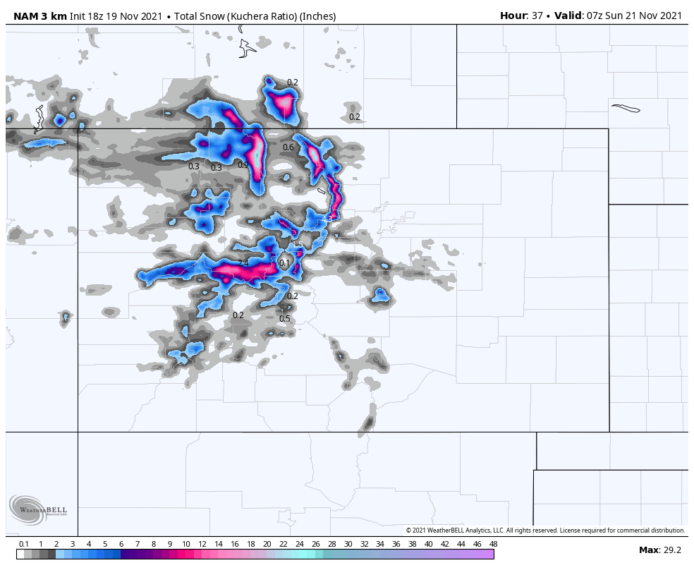
Below is the NAM model output for total precipitation through Saturday night. I think it’s aiming a bit high on precipitation for the Park Range and Continental Divide, but I think out of all the models, it gives the most accurate representation of where I think the most snow will fall. Multiply these values by about 12 to get a rough approximation for snow (maybe 14-15 for the upper peaks):

Forecast By SnowBrains Junior Meteorologist – Clay Malott
5:50 PM MST, 11/18/2021
Extended forecast
Things are looking good for a strong pattern to move in next week. A “white Thanksgiving” is fairly likely, with most models agreeing on Wednesday and Thursday to be the most probable storm timing! Below is the European (left) and American (right) ensemble forecasts:
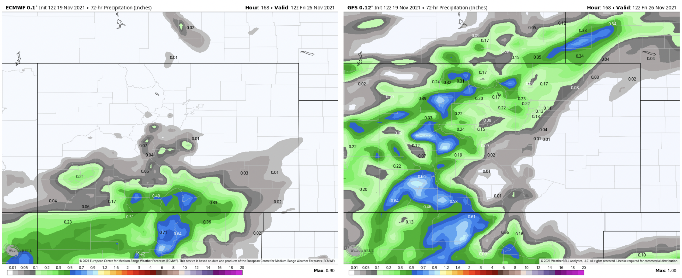
The European and Canadian deterministic models have the precip bullseye in southern Colorado and northern New Mexico, but the GFS (American) model has it coming straight from the West, which would share the precipitation fairly evenly between the north and south of Colorado.
Below is the European (left) and American (right) deterministic precipitation forecast on Wednesday and Thursday. Pretty big difference!
I won’t even try to forecast specific values until there’s some model agreement on the next storm. Certainly, something to maybe start getting excited for! I’ll post an updated forecast this weekend or early next week and see how things are shaping up in terms of totals.