NASA shared this stunning satellite comparison image over the weekend, showing an Antarctica ice-cap before and after its hottest recorded temperature. The images are separated by just 11-days!
On February 6, 2020, weather stations recorded the hottest temperature on record for Antarctica. Thermometers at the Esperanza Base on the northern tip of the Antarctic Peninsula reached 18.3°C (64.9°F)—around the same temperature as Los Angeles that day. The warm spell caused widespread melting on nearby glaciers.
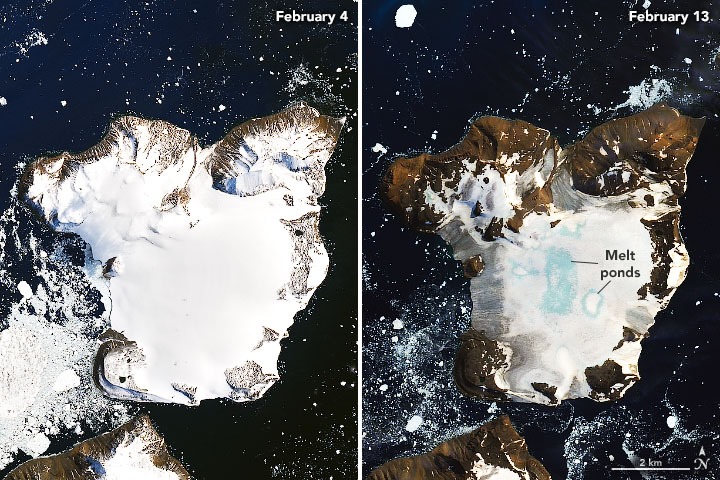
The warm temperatures arrived on February 5 and continued until February 13, 2020. The images above show melting on the ice cap of Eagle Island and were acquired by the Operational Land Imager (OLI) on Landsat 8 on February 4 and February 13, 2020.
Mauri Pelto, a glaciologist at Nichols College observed that during the warming event, around 1.5 square kilometers (0.9 square miles) of snowpack became saturated with meltwater (shown in blue above). According to climate models, Eagle Island experienced peak melt—30 millimeters (1 inch)—on February 6. In total, snowpack on Eagle Island melted 106 millimeters (4 inches) from February 6- February 11. About 20 percent of seasonal snow accumulation in the region melted in this one event on Eagle Island.
“I haven’t seen melt ponds develop this quickly in Antarctica,” said Pelto. “You see these kinds of melt events in Alaska and Greenland, but not usually in Antarctica.” He also used satellite images to detect widespread surface melting nearby on Boydell Glacier.
Pelto noted that such rapid melting is caused by sustained high temperatures significantly above freezing. Such persistent warmth was not typical in Antarctica until the 21st century, but it has become more common in recent years.