SnowBrains Header logo
  • Milano Cortina 2026
  • Home
  • News
  • Weather
  • Resort Reports
  • Brains
  • Podcast
  • 300 Movie
  •  
SnowBrains Facebook Page SnowBrains Twitter Page SnowBrains Instagram Page SnowBrains YouTube Page SnowBrains RSS Feed

map

SnowBrains Podcast Ep. 100 | Will Sladek – General Manager of onX Backcountry

SnowBrainsPodcastLogo_3.0_3840x2160_onX(compressed)

Will Sladek is the General Manager of onX Backcountry. Will helps lead one of the most influential tools in modern backcountry travel. onX Backcountry has changed how skiers, snowboarders, and mountain travelers plan routes, manage risks, and understand terrain. From mapping and land ownership to avalanche forecasting, weather, and now high-resolution satellite imagery, onX has become a go-to platform for […]

Post Tag for BackcountryBackcountry
Play Video
Podcast | January 20, 2026
0 Comments

December 2025 State of the Western U.S. Snowpack: Well Below Average and Downright Abysmal in Places

It’s the start of December, and winter is beginning to take shape across the Western U.S., though it’s been slow in some places. By this time of year, many skiers and snowboarders should have had their first days on the mountain; however, many ski areas haven’t had enough snow to open yet. The slow start to the season has December snowpack levels well […]

Post Tag for WeatherWeather
Avatar photo Brent Glogau | December 1, 2025
1 Comment

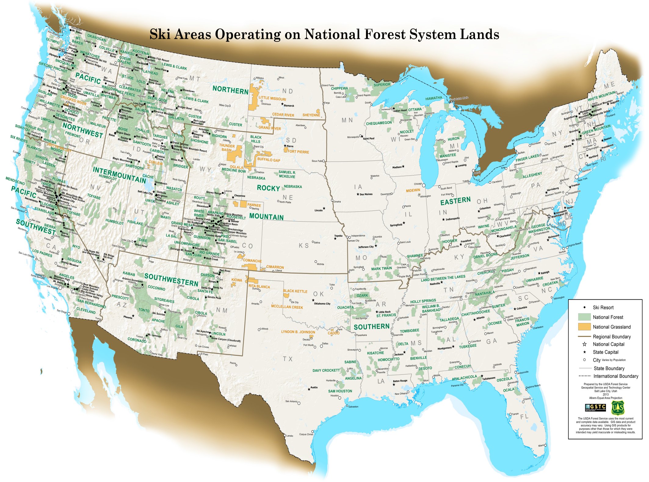
[MAP] Every Ski Area on U.S. Forest Service Land

You might have to do some squinting, but above is a graphic of every ski area operating on U.S. Forest Service Land.  Is your home mountain on USFS land? Related: Topographic Ski Maps: A New Way of Tracking Resort Days

Post Tag for BrainsBrains
Avatar photo SnowBrains | August 9, 2022
1 Comment

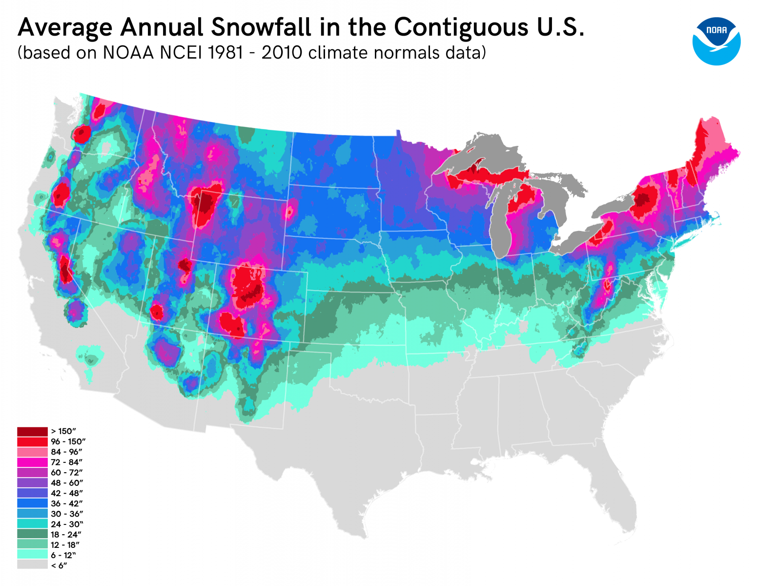
Map of Average Annual Snowfall in Contiguous U.S.

A map of average annual snowfall in the contiguous U.S. visually explained.  Dark red zones on this map are where we want to be! The Dark Red Zones: Sierra Nevada Range, CA/NV Teton Range, WY Wasatch Range, UT Front Range, CO Cascade Range, OR & WA Related: NOAA April 2021 Outlook: Warmer and Drier Than Normal For Majority of Country

Post Tag for BrainsBrains
Avatar photo SnowBrains | March 25, 2021
4 Comments

Top 5 Backcountry Runs Around South Lake Tahoe

Lake Tahoe, backcountry, map

This is a guest post written by Eddy van der Kloot, mapmaker and owner of Backcountry Ski Maps Lake Tahoe is home to some of the finest backcountry terrain in the world, and while locals might argue over whether Truckee or South Lake has the best touring, the truth is that you can’t go wrong with either side of the […]

Post Tag for BackcountryBackcountry
Guest Author | February 11, 2021
0 Comments

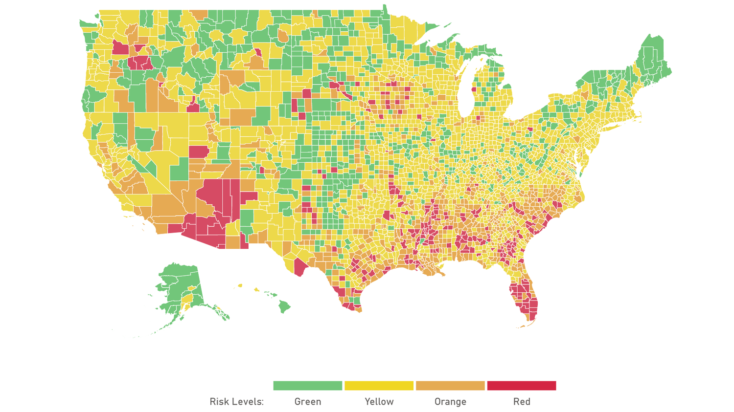
New Interactive Map and Dashboard Lets You Find Out How Bad Your County’s Coronavirus Outbreak Is

How bad is the coronavirus outbreak in your county, really? With this new interactive map and dashboard, you can track community spread county by county and see if you’re in a green, yellow, orange, or red threat level area. Currently, there are two states with a ‘red’ danger level: Arizona and Florida.  And one state in the ‘green:’ Hawaii.  To […]

Post Tag for BrainsBrains
Avatar photo SnowBrains | July 7, 2020
0 Comments

Comparing the True Size of Every Country

size comparison of countries

Most representations of the world do not accurately project their true size, this visualization does. The Mercator projection is a cylindrical projection of the world that was created for nautical navigation. This projection, while the most common projection, has a large flaw–it distorts the size of most countries. Related: Map Created Overlaying Modern Countries on Pangea The largest problem with projecting […]

Post Tag for BrainsBrains
Alex Camerino | July 3, 2020
16 Comments

VIDEO: Eric Hjorleifson’s Biggest Ski Crashes… Ever!

[arve url="https://youtu.be/pcoSmdo4iec"]
Avatar photo SnowBrains | May 29, 2020
Likes
Tweets
0 Comments

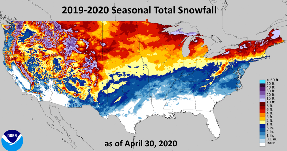
Visualization of America’s Biggest Snowfall Totals Winter 2019-20

This graphic provided by the NOAA visualizes the largest snowfall totals in the United States during the 2019-20 winter season. RELATED: Weather Outlook for May: Warmer than Average for the Southwest, Cooler for Great Lakes Region Looks like the purple is where you want to be… RELATED: Summer 2020 Weather Outlook

Post Tag for Conditions ReportConditions Report
WeatherBrains | May 1, 2020
0 Comments

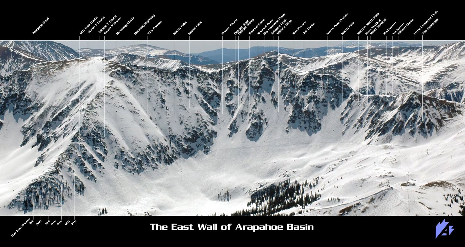
Arapahoe Basin Ski Area, CO Releases New, Detailed Map of the East Wall

The East Wall at Arapahoe Basin Ski Area is arguably one of the best — if not the best — parts of the mountain to ski. With dozens of break-neck lines and seemingly endless expert terrain, this zone is legendary. A-basin just released a brand-spankin’-new map of the East Wall that can be found on their website for all you […]

Post Tag for Industry NewsIndustry News
Avatar photo SnowBrains | February 28, 2020
0 Comments

MAP: Current Snowpack Status for the Western United States

  Lifts are beginning to spin around the country as ski season makes its official arrival. Current snowpack levels differ from region to region, with some places like Montana having a snowpack that is 300% above average and other places like Lake Tahoe that have less than 5% of their average. Above is a map showing you which areas have […]

Post Tag for WeatherWeather
Avatar photo SnowBrains | November 19, 2019
0 Comments

US 212 Beartooth Highway, MT/WY CLOSED Due to SNOW Conditions

beartooth, highway, map, US 212, closed, Montana, wyoming

Winter has returned with a vengeance to the Beartooth Highway, leading to the famed road closing last night due to blowing snow and drifting conditions. The scenic highway closed at Vista Point on US-212 at 3:30 p.m. yesterday, according to the Montana Department of Transportation. The closure, located south of Red Lodge, is due to drifting and blowing snow as […]

Post Tag for WeatherWeather
WeatherBrains | September 12, 2019
2 Comments

Trail Map Artist James Niehues Wins Hall Of Fame Nomination

If you’ve ever been to a ski resort, chances are you’ve laid eyes on one of artist James Niehues’ paintings. Iconic, precise and visually pleasing, Niehues has created over 350 views of mountain aspects for ski resorts since his first painted map in 1988. His paintings are featured all over the world. James Niehues hand paints each painting with brush and […]

Sydney Stephens | September 6, 2019
0 Comments

What’s Your Risk of Fire? California Wildfire Hazard and Risk Map About to Get a Huge Upgrade

fire, risk, wildfire, maps

Unfortunately, wherever you live in California, you probably face the threat of wildfire. But the likelihood and danger can vary dramatically depending on exactly where you live, and you can currently assess that risk using a set of maps released in 2007, reports KQED. But over the next year, that’s going to change. Updated draft maps to test are being […]

Post Tag for FireFire
Firebrains | July 19, 2019
0 Comments

VIDEO: MSP’s ‘Drop Everything’ Markus Eder Full Segment | Big Airs and Insane Ski Action

[arve url="https://youtu.be/gWfaJ92-D9Y"]
Avatar photo SnowBrains | April 19, 2019
0 Likes
2 Tweets
0 Comments

Real-Time and Interactive Map of Current Wildfires in the USA

wildfire, interactive map

There are currently 85 active wildfires blazing in the USA, and this interactive, real-time map shows them all. Esri’s mapping software is some of the most advanced and powerful available and puts the ability to filter down to individual blazes, or by the current magnitude and start date, at your fingertips. If you hover over each area, you’ll learn the name […]

Post Tag for FireFire
Firebrains | August 23, 2018
0 Comments

Visiting a National Park? There’s a (Free!) Map For That

brochures, collection, download, free, national park, nps, ranger

Summer is here and America’s national parks are full of visitors. If you’re currently one of them or plan to be soon, you need this site, National Park Maps, in your life. We all have fond memories of arriving at a national park. You arrive at the entrance booth, hand the ranger your money, and in return receive a brochure-like map. It’s the […]

Steven Agar | July 28, 2017
0 Comments

NOAA: “El Nino is Brewing…” | Big Snow for Western US in 2014/15?

NOAA and many other organizations are monitoring the potentially strong El Nino that is beginning to take form in the Pacific Ocean. El Nino generally means big snow for Lake Tahoe, Taos, Flagstaff, SoCal, Utah, and SW Colorado. If you don’t live in one of these zones, it might be time to modify your winter 2014/15 plans. Check out […]

Post Tag for WeatherWeather
Avatar photo SnowBrains | April 29, 2014
1 Comment

Brain Post: Map of Where NOBODY Lives in the USA | 47% of the USA Is Uninhabited

The dark green blocks in the maps above represent U.S. Census blocks where the reported population equals zero. These maps above show us, in green, where nobody lives in the USA. We often think that we just can’t get away from people, but if you head out West, you can get into some truly uninhabited zones. What we love is that California is the most populous state with 37 million people, yet look how much uninhabited land there is in California. Another great contrast in CA. A Block is the smallest area unit used by the U.S. Census […]

Post Tag for Featured ArticleFeatured Article
Avatar photo SnowBrains | April 23, 2014
15 Comments

US Snow Cover & Snow Depth Right Now VS Last Year:

us snow cover map

It’s no secret that it’s been damn cold in the USA and that snow cover has been much higher than normal for this time of year. Last year had less overall snow coverage but where we had snow, then snow was deep last year in many spots. Just look at the snow coverage map for this year! Idaho, Montana, Utah, Oregon, Washington, and Nevada are nearly completely covered in snow. Even California is pretty darned buried. Impressive. The far northern rockies and the far northern pacific northwest do have deeper snowpacks this year compared to last year, though. […]

Post Tag for WeatherWeather
Avatar photo SnowBrains | December 16, 2013
0 Comments

Share your story:

Submit A Link

Top 10 Trending right now:

  • Les 3 Vallées, France, Report: "Flabbergasted" by 25,000 Acres of Lift-Accessed Couloirs, Trams, & True Big-Mountain Terrain
    Les 3 Vallées, France, Report: "Flabbergasted" by 25,000 Acres of Lift-Accessed Couloirs, Trams, & True Big-Mountain Terrain
  • Why is That Tree Covered in Bras and Beads at the Ski Area?
    Why is That Tree Covered in Bras and Beads at the Ski Area?
  • 2 British Tourists Die in Massive Avalanche That Killed 3 in Val d'Isère, France
    2 British Tourists Die in Massive Avalanche That Killed 3 in Val d'Isère, France
  • French Ski Resorts Close Due to Extreme Avalanche Danger
    French Ski Resorts Close Due to Extreme Avalanche Danger
  • Master Plan for Fortress Mountain, AB, Revival Released: Its History, Why it Failed, and Why it Could Now Be Successful
    Master Plan for Fortress Mountain, AB, Revival Released: Its History, Why it Failed, and Why it Could Now Be Successful
  • Wrongful Death Lawsuit Filed After Skier Dies in Avalanche During Mount Bailey, OR, Cat-Skiing Trip
    Wrongful Death Lawsuit Filed After Skier Dies in Avalanche During Mount Bailey, OR, Cat-Skiing Trip
  • Extreme Caution Urged: Major Avalanche Conditions Grip the French Alps
    Extreme Caution Urged: Major Avalanche Conditions Grip the French Alps
  • Rolling Snow in the Dark: A Snow Groomer’s Life
    Rolling Snow in the Dark: A Snow Groomer’s Life
  • With the Worst Ski Season in Decades Underway Out West, 70% of Skiers in the West Say They Still Wouldn't Fly Out East to Ski
    With the Worst Ski Season in Decades Underway Out West, 70% of Skiers in the West Say They Still Wouldn't Fly Out East to Ski
  • Whitewater, BC, Report: "Ski Bums Don't Die, They Move to Nelson"
    Whitewater, BC, Report: "Ski Bums Don't Die, They Move to Nelson"
  • Meet the Team
  • Contact
  • Privacy Policy
  • Editorial Policy
  • Site Map