Jackson Hole, WY is a hot mess right now.
- 17 downed power lines have left Teton Village without power and the ski resort closed until at least Monday.
- All the hotels in Teton Village had to be evacuated due to the loss of power.
- It’s POURING rain up to 8,500′ today and yesterday.
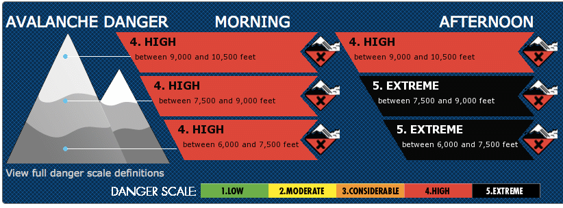
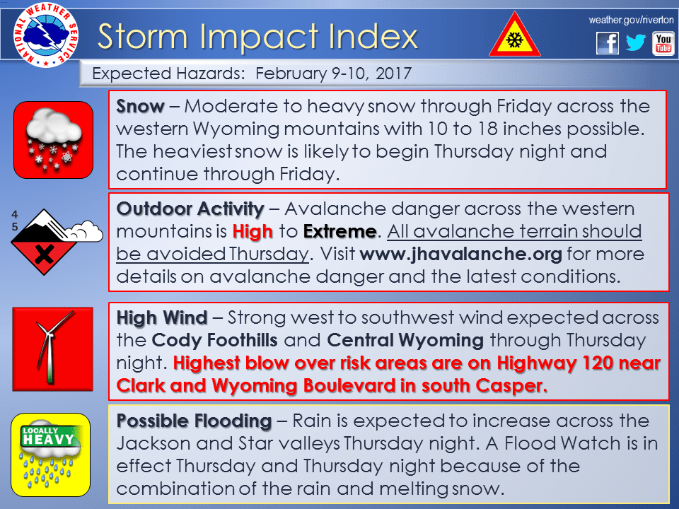
- The Avalanche Danger is Extreme and High in the Tetons today | Avalanche Warning Issued
- Flood Warning Issued by NOAA
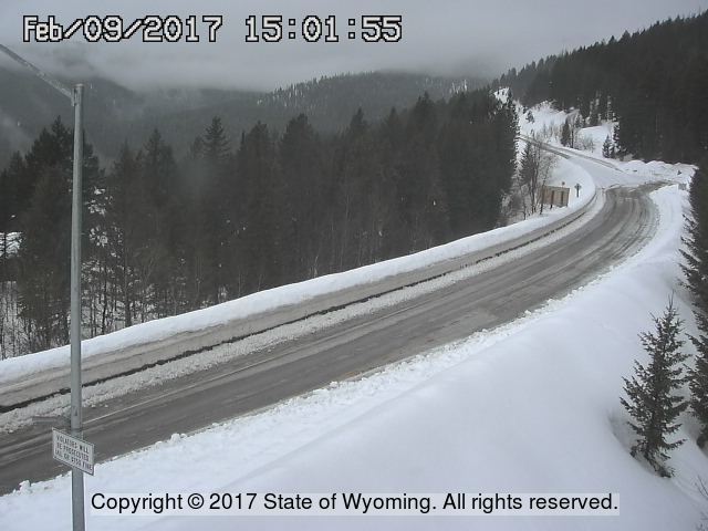
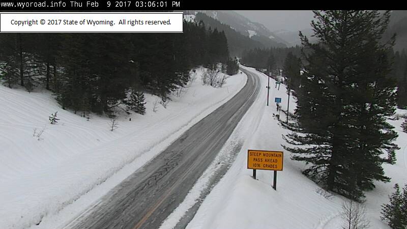
- Teton Pass, WY closed on Tuesday and has not reopened since. It’s estimated to reopen on Saturday.
“On Tuesday night, at least 6 avalanches released naturally on the west side of Teton Pass, leaving 12 to 15 feet of debris on the road.” – Jackson Hole Daily, today
“WYDOT has issed a “no unnecessary travel” order on highways, meaning that if you can stay home, you should.” – Jackson Hole Daily, today

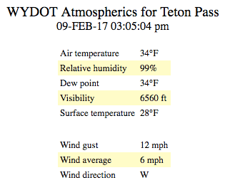
More Storm Information:
Jackson Hole: 1+” of Rain With Heavy Snowfall In The Morning
* Summary...Significant rainfall combined with melting snow may
  cause localized flooding in portions of the Jackson and Star
  Valleys through tonight.
- NOAA Riverton, WY
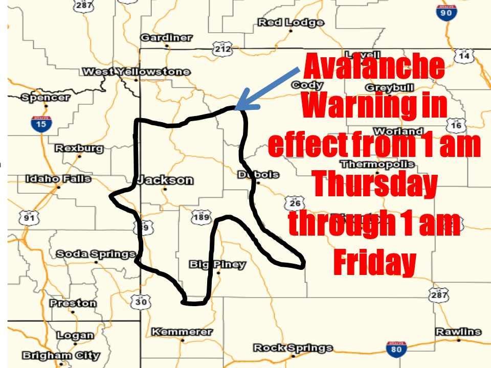
Avalanche Warning For Jackson Hole:
WYZ012>014-023-024-100800-
TETON AND GROS VENTRE MOUNTAINS-JACKSON HOLE-
WIND RIVER MOUNTAINS WEST-STAR VALLEY-
SALT RIVER AND WYOMING RANGES-

BULLETIN - EAS ACTIVATION REQUESTED
AVALANCHE WARNING
BRIDGER-TETON NATIONAL FOREST AVALANCHE CENTER
RELAYED BY NATIONAL WEATHER SERVICE RIVERTON WY
615 PM MST WED FEB 8 2017

TIMING...1 AM ON FEBRUARY 9TH THROUGH 1 AM ON FEBRUARY 10TH.

AFFECTED AREA...TETON, SNAKE RIVER, GROS VENTRE, WIND RIVER,
WYOMING, AND SALT RIVER RANGES. THIS ALSO INCLUDES JACKSON HOLE
AND STAR VALLEY.

AVALANCHE DANGER...THE AVALANCHE DANGER WILL BE HIGH FOR THE
AFFECTED AREA.

REASONS AND IMPACTS...FORECAST HEAVY SNOW, AND RAIN THAT COULD
RISE TO 8000 FEET, WILL CREATE WIDESPREAD AREAS OF UNSTABLE SNOW.
NATURAL AVALANCHES ARE LIKELY AT ALL ELEVATIONS, COULD RUN LONG
DISTANCES AND IMPACT ROADWAYS. DANGEROUS ROOF SLIDES ARE CERTAIN.

PRECAUTIONARY / PREPAREDNESS...TRAVEL IN OR UNDER AVALANCHE
TERRAIN IS NOT RECOMMENDED.


Flood Watch For Jackson Hole:
Flood Watch
National Weather Service Riverton WY
1210 PM MST Thu Feb 9 2017

...RAIN MAY BRING SOME FLOODING TO THE JACKSON AND STAR VALLEYS
THROUGH TONIGHT...

.A warm Pacific system will bring widespread rain to the area
through tonight. The rain will change to snow by Friday morning
though with heavy snow possible on Friday.

Jackson Hole-Star Valley-
Including the cities of Jackson, Afton, Alpine,
Star Valley Ranch, and Thayne
1210 PM MST Thu Feb 9 2017

...FLOOD WATCH REMAINS IN EFFECT THROUGH LATE TONIGHT...

The Flood Watch continues for

* Location...Portions of northwest Wyoming and west central
  Wyoming, including the following areas, in northwest Wyoming,
  Jackson Hole. In west central Wyoming, Star Valley.

* Timing...Through late tonight

* Summary...Significant rainfall combined with melting snow may
  cause localized flooding in portions of the Jackson and Star
  Valleys through tonight. Colder air will arrive quickly by
  sunrise Friday morning and will likely change all areas over to
  a heavy wet snow.

The warmer temperatures and rain will loosen up snow that is currently on homes. Watch out for Roof Avalanches!