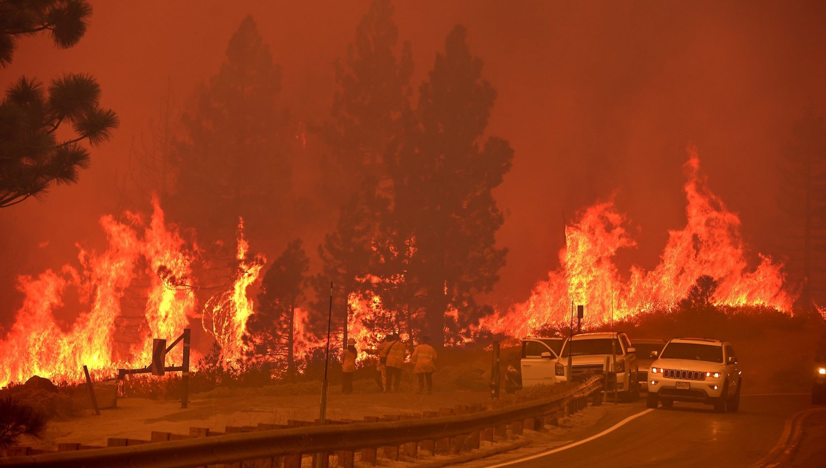
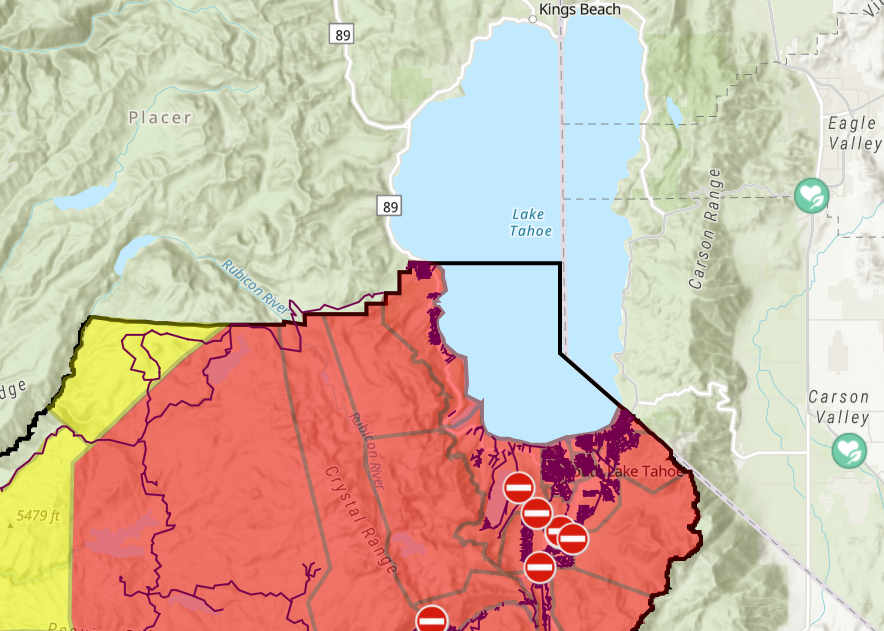
After reaching Sierra at Tahoe Ski Area on Sunday and burning through it, the Caldor Fire pressed forward and entered the Lake Tahoe Basin on Monday. The 191,607-acre fire (299 square miles) entered the Tahoe Basin only hours after the entire city of South Lake Tahoe and surrounding areas along the west and south shores were ordered to evacuate. The fire jumped Highway 89 late Monday near Christmas Valley, hitting a cluster of homes and cabins between highways 50 and 89 just east of the summit and about two miles south of Meyers, according to the Sacramento Bee.
The fire is now threatening close to 34,000 structures and has already destroyed nearly 500 homes, as well as some cabins, according to Cal Fire and the U.S. Forest Service. About 3,900 fire personnel are assigned to the Caldor fire as it burned over Echo Summit Monday night when it entered into the Tahoe Basin.
INTENSE FIRE along Hwy 50 just on the Tahoe side of Echo Summit.
Cabins involved. Major torching/crown fire.@tylermhorst & I had to bail on this location just now. @ABC10 #CaldorFire pic.twitter.com/gfNi9mSktj
— Brandon Rittiman (@BrandonRittiman) August 31, 2021
Over 53,000 people in the Tahoe Basin were evacuated on Monday afternoon, with sweeping orders forcing residents from Meyers and South Lake Tahoe to leave through the Nevada Stateline. The entire town is now a sitting duck and has an eerie emptiness that can only be seen by fire personnel as town residents anxiously wait elsewhere to see what happens to their home on Lake Tahoe, according to the Sacramento Bee.
Fire officials were forced to expand the evacuation warnings into Nevada including Highway 50 all the way to Kingsbury Drive. The casinos at Stateline are currently exempt from the warning since they are housing a significant amount of evacuees.
The Caldor Fire sparked south of Pollock Pines, California on Aug. 14 and has crept along Highway 50 for more than two weeks. It has crossed the entire width of the Sierra Nevada mountain range, becoming only the second fire in recorded history to do so after the Dixie Fire earlier this year. Winds and critically dry conditions could continue to push the Caldor Fire deeper into the basin Tuesday, as thousands of firefighters work to protect structures and contain the wildfire.
The Caldor Fire is currently 16% contained.
#CaldorFire makes a push in to Meyers as it spots over Highway 50 and down in to Christmas Valley, then spotted over hwy 89 as it pushes towards South Lake Tahoe. @NorthBayNews pic.twitter.com/lse0TSiclu
— Kent Porter (@kentphotos) August 31, 2021
More than 52,000 residents of El Dorado County are now evacuated, according to the Governor’s Office of Emergency Services, with mandatory orders stretching from the Pollock Pines area to the California-Nevada state line—essentially, the entire eastern half of the county.
Mandatory evacuation orders were issued Monday morning for the entire city of South Lake Tahoe as well as communities along the west shore including Emerald Bay, Meeks Bay, and Tahoma. Orders also extended into Amador and Alpine counties on the south side of the fire. Orders have not been issued in Placer County, north of El Dorado.
Meanwhile, the National Forest Service announced a temporary closure of all National Forests in California on Tuesday to better provide public and firefighter safety due to the ongoing California wildfire crisis. This closure will be in effect from Aug. 31, 2021, at 11:59 pm through September 17, 2021, at 11:59 pm. This order does not affect the Humboldt-Toiyabe National Forest, which is not in the Pacific Southwest Region.
Squaw Valley Alpine Meadows and Mammoth Mountain have closed all summer activities until further notice to discourage recreation and travel, and to allow fire fighting resources to concentrate on the Caldor Fire. Squaw Valley Alpine Meadows wrote in a social post on Monday:
“This is not the time to come to Tahoe for recreation or vacation. While the Caldor Fire is not currently a threat to Alpine Meadows or Olympic Valley, it is imperative that all area resources are concentrated on fighting this fire and getting residents to safety. As many of our employees and neighbors are facing evacuation orders, please refrain from adding cars to our roads when evacuation is the number one priority.” -Squaw Valley Alpine Meadows
View this post on Instagram
Here are all the current evacuations for the Caldor Fire:
AMADOR COUNTY
Evacuation Order:
- South of Highway 88 along the Amador/El Dorado County line from Dufrene Road, due east to the Amador/Alpine County line and from the Amador/Alpine County line north to Highway 88. This includes the area of Kirkwood Lake.
Evacuation Warning:
- South of the Amador/El Dorado County line along Highway 88 from Dufrene Road west to Omo Ranch Road.
- North of Tiger Creek Road east to Salt Springs Reservoir Road to the east end of the Salt Springs Reservoir.
- West of the Amador/Alpine County line to Highway 88.
- East of Highway 88 to the Amador/Alpine County line
Road Closures:
- Highway 88 is closed between Omo Ranch Rd. and the Highway 88/89 interchange.
EL DORADO COUNTY
Evacuation Orders:
- Grizzly Flat: The areas on Grizzly Flats Road east of Kendra Way into Grizzly Flats Proper. The areas of Diamond Railroad Grade, Old School House, Sweeney Road, Caldor Road, and steely Ridge.
- Flats Proper. The areas of Diamond Railroad Grade, Old School House, Sweeney Road, Caldor Road, and steely Ridge.
- Grizzly Flats Road east of four corners in somerset into Grizzly Flats Proper.
- The areas of Myers Lane, Varmet Ridge Road, Rodwell Canyon Road, Snowbird Lane, and Mehwald Lane.
- East of Sly Park Road between Highway 50 and Mormon Emigrant Trail to Ice House Road. This includes the communities of Pacific House and Fresh Pond.
- North of Highway 50, east of Forebay Road to Ice House Road.
- Intersection of Perry Creek and Hawk Haven, the East side of Fairplay Road from Perry Creek South to Cedarville Road. This includes Slug Gulch, Omo Ranch, and all roads off of Slug Gulch and Omo Ranch.
- All roads off of Omo Ranch from Cedarville Road to Hwy 88.
- The area between Highway 88 and Mormon Emigrant Trail
- South of Highway 50 from Snows Road to Ice House Road.
- Between Highway 50 and Slab Creek from Snows Road to Ice House Road.
- South of Highway 50 from Ice House Road to Silver Fork Road. This includes the community of Kyburz.
- North of Highway 50 from Ice House Road to Silver Fork Road to include Ice House Reservoir, Union Valley Reservoir, and Loon Lake.
- Silver Fork Road in Kyburz east to Twin Bridges.
- North and south in a line extending from Twin Bridges to the Placer County line and south to the Amador County line.
- From Twin Bridges east to Echo Summit.
- From Highway 50 South to Amador/ Alpine County Line.
- From Highway 50 North to Flag Pole Peak.
- Pleasant Valley Road and all intersecting roads extending south from Newtown Road to the intersection of E-16 (Mt Aukum Road).
- All roads accessed from E-16 (Mt Aukum Road) between Pleasant Valley Road and Bucks Bar Road.
- This includes all roads and residences accessed from Moon-Shadow and Gopher Hole Road off Bucks Bar Road.
- Christmas Valley from Highway 89 West to Echo Summit
- Highway 89 due West to Watershed Ridge/Echo Summit and South to the Amador/El Dorado County line.
- The area from Luther Pass Road, north along the El Dorado/Alpine County line to Armstrong Pass. West from Armstrong Pass to Upper Apache at Meyers. West on Upper Apache to Highway 50. West on Highway 50 to Highway 89. South on Highway 89 to the El Dorado/Alpine County line. This includes all homes on both sides of Highway 89.
- The area from Upper Apache at Meyers, north along Highway 50, to Elks Club Drive. East on Elks Club Drive to Pioneer Trail, extending due south to Upper Apache at Meyers. (This includes all homes off of Oneidas, Mandan, Apache, Ottawa, and Player).
- The area North on Highway 50 from Highway 89 to Saw Mill Road. West on Saw Mill Road to Angora Ridge, extending to the Echo Summit.
- Desolation Wilderness from the watershed ridge to the CA ENF/CA TMU wilderness boundary. From the El Dorado/Placer county line to Echo Lakes.
- The section from Emerald Bay north to the Placer county line in Tahoma, extending west to the border of Desolation Wilderness.
- The area from Sawmill Road at Lake Tahoe Blvd. extending north to Pope Beach. Along the water’s edge to Eagle Point. From Eagle Point west, to Desolation Wilderness, across Emerald Bay.
- This is the area North of Elks Club along Highway 50 and the West side of Pioneer Trail, also including the streets of Hekpa, excluding the residences west of the airport, this segment includes all residences accessed from Jicarilla, Washoan, and Glen Eagles. This also includes the Golden Bear neighborhood, and the neighborhoods of Cold Creek Trail, High Meadows, and Marshall Trail.
- Northwest of the South Lake Tahoe Airport and west of the Highway 50 / Lake Tahoe Blvd and Highway 89 intersection to include the South Lake Tahoe High School, Tahoe Verde and the streets accessed from 5th through 15th street south of Highway 89.
- The area East of Pioneer Trail to the Alpine County Line stopping South of Heavenly Ski Resort, excluding all residence off of Pioneer Trail.
- All residences with the Tahoe Keys community and all residents accessed from the streets connEast of Highway 50/ Highway 89 at the at the Lake Tahoe Blvd and
Highway 89 Highway 50 intersection. This includes the area of Barton Hospital and the area of Winnemucca to the “Y”. Also north of Highway 50 west of Tahoe Keys Blvd following along the north side of Highway 89 through the end of town prior to Pope Beach.ected to Tahoe Keys Blvd, staying east of 3rd Street. - All residences off of Lakeview which is west of Highway 50 North of Blue Lakes Road and east of Tahoe Keys Neighborhood.
- All residences on both sides of Highway 50 for the streets connected to O’Malley, Lodi, Silver Dollar and Rubicon Trail.
- The residences between Al Tahoe on the east side of Johnson Blvd to include the streets of Treehaven and Fremont and extending to the east in to all residences west of Ski Run and east of Pioneer Trail.
Evacuation Warnings:
- North of Slab Creek to Wentworth Springs Road between Sand Mountain and Loon Lake.
- Mosquito Road from the bridge North to include the Community of Swansboro.
- North of Highway 50 to Slab Creek between Smith Flat and Snows Road.
- South of Highway 50 to Pleasant Valley between Smith Flat and Snows Road, and North of Pleasant Valley between Holm and Newtown.
- South of Pleasant Valley between Bucks Bar Road and Newtown Road, East of Bucks Bar Road to Kingsbury Drive.
- Southwest of Bucks Bar Road to Ladies Valley Road including the community of Outingdale, Ant Hill Road, Perry Creek Road, and Sand Ridge between Ladies Valley Road and Bucks Bar Road.
- East of Mt Aukum Road (E16) from Bucks Bar Road to Omo Ranch Road. North of Omo Ranch Road to the intersection of Omo Ranch Road and Fairplay Road.
- From the evacuation order line in Twin Bridges east to the Echo Summit and from Highway 50 south to the Amador and Alpine County lines and north to the Placer County line
- Dry Lakes Section: This section is north of Wentworth Springs Road up to the Placer County line and the remaining section of El Dorado County south of Placer County to Loon Lake.
- The area from Sawmill Road at Lake Tahoe Blvd. extending north to Pope Beach. Along the water’s edge to Eagle Point. From Eagle Point west to Desolation Wilderness, across Emerald Bay
- The remaining area of the Lake Tahoe Basin. From the Alpine/El Dorado county line, north along the California/Nevada state line to Lake Tahoe. North along the waters edge to the El Dorado/Placer county line. West along the El Dorado/Placer county line to McKinney Lake
Road Closures:
- Highway 50 is closed in both directions from the Sly Park Road exit to Meyers (Highway 50 and Highway 89 junction).
- The Highway 50 closure has been extended East to Sawmill Road
- Highway 50 at Sawmill
- Pioneer Trail at Elks Club
- Elks Club at Highway 50
- Highway 89 at Highway 88 junction
- Fallen Leaf at Tahoe Mountain
ALPINE COUNTY
Evacuation Order:
- Highway 89 south from Luther Pass Road to Pickett’s Junction, (Highway 88) West on Highway 88 to Kirkwood. This includes Kirkwood resort and Caples Lake.
Evacuation Warning:
- Highway 88 at Forestdale Road. West of Forestdale Road and south to the Pacific Crest Trail Crossing. West of the Pacific Crest Trail to the Summit City Canyon Trail. West of Summit City Canyon Trail and south to the El Dorado / Stanislaus National Forest Line. El Dorado / Stanislaus National Forest Line west to the Alpine and Amador County line.
- South of Armstrong Summit to Woodfords to Forestdale Road, north of Highway 88 and Highway 89 to Armstrong Summit.
EVACUATION CENTERS:
EL DORADO COUNTY SHELTERS
- Shelter
Green Valley Community Church
3500 Missouri Flat Road
Placerville, CA - Shelter
Cameron Park CSD
2502 Country Club Drive
Cameron Park, CA - Shelter
Rolling Hills Church
800 White Rock Road
El Dorado Hills, CA
AMADOR COUNTY
- Temporary Evacuation Point
Italian Picnic Grounds in Sutter Creek
581 Hwy 49
Sutter Creek, CA 95685
NEVADA COUNTY
- Shelter
Truckee Veterans Hall
10214 High Street
Truckee, CA 96161
NEVADA STATE
- Shelter
Truckee Veterans Hall
10214 High Street, Truckee, CA 96161 - Shelter
Douglas County Community Center Shelter is at capacity
1329 Waterloo Lane, Gardnerville, NV - Shelter
Carson City Community Center
851 E. William Street, Carson City, NV - Shelter
Carson High School
1111 N. Saliman Road, Carson City, NV
ANIMAL EVACUATION CENTERS:
EL DORADO COUNTY
- El Dorado County Animal Services (small animals)
6435 Capitol Ave.
Diamond Springs, CA
For animal evacuation questions or assistance call (530) 621-5795 - Saureel Vineyards (large animals) FULL
1140 Cold Springs Road
Placerville, CA
(530) 621-5795
AMADOR COUNTY
- South County Large Animal Rescue (SCLAR)
Amador County Fairgrounds (large and farm animals)
El Dorado County residents only
18621 Sherwood Street
Plymouth, CA
- Amador County Animal Response Team- ACART
Amador County Fairgrounds (large and small animals)
18621 Sherwood Street
Plymouth, CA
For Amador County residents only
(209) 257-9444 - Italian Picnic Grounds in Sutter Creek – Temporary Evacuation Point
581 Hwy 49
Sutter Creek, CA 95685
NEVADA
- Douglas County Animal Services (small animal)
921 Dump Road
Gardnerville, NV
(775) 782-9061 - East to West Coast Grooming
1368 Hwy 395, Unit B1
Gardnerville, NV
(775) 450-1743 - Douglas County Animal Services (livestock)
Douglas County Fairgrounds
920 Dump Road
Gardnerville, NV
(775) 782-9061
Even if you fix global warming tomorrow, it will not fix the wildfire problem we’re currently having.
Who asked you? You need a new game bruh. You are weird, goofy mutha
Thank you. Trying to create discussion around important issues. I say crazy stuff in the hope to make people think about solutions and hopefully do their own research and get educated.
Stuff like this isn’t very complicated. Our society has unfortunately become incredibly dumb.
If we want to solve problems we have to 1st understand the root cause of the problem. Too much of our lives is ran by clickbait and politically charged emotional issues. It blows my mind a large % of the media out there says the only culprit to the wildfire problem is climate change. It’s absolutely insane. It’s makes me incredibly sad how dumb our society has become.
I have a great idea. Let’s drop everything, fix climate change, and pray the wildfires are going to fix themselves. It’s going to work team. Have faith….
Please pick up a book or just read some educational papers about how and why the forest has changed over the last 100-150 years because of man and then maybe you’ll have a sense of what we need to do to return it to a more natural state. Please read. Please.
Oh shoot. I probably wrote too many words for our buddy AnOnYmOuS. People like him are the root of our problem. Can’t read, can’t write, can’t think outside the box. He does have a liberal arts degree, some tattoos, a nose ring and a edgey Instagram profile though…