Weather is utterly important in skiing. Obviously, there would be no snow without weather, and with no snow, there would be no skiing. So understanding the weather—its quirks, mechanisms, its patterns—is very important for our “quality of skiing” forecasts (snow forecasts). One lesser-known aspect of our meteorology arsenal is the world of teleconnections, which help inform medium and long-range forecasts.
First, what is a teleconnection? According to the NOAA, a teleconnection is a “recurring and persistent, large-scale pattern of pressure and circulation anomalies that spans vast geographical areas.” In other words, these teleconnections are patterns that repeat themselves in a regular or irregular cycle.
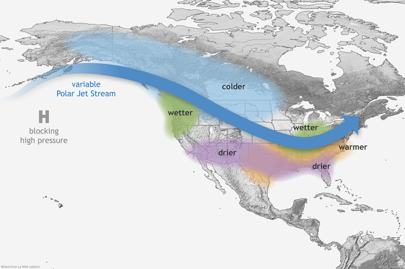
The most famous teleconnection is the ENSO, which is the infamous El Niño (positive phase) and La Niña (negative phase). Since the ENSO is so well-known, I won’t go into it too much since this article is meant to explore a few of the lesser-known teleconnections. If you’re interested in learning more about ENSO, you can check out this article.
There are dozens of teleconnections worldwide, each repeating at different intervals and with varying severity of their impacts on weather. More teleconnections are being discovered each year, and someday, we might even have a teleconnection that PERFECTLY tells us what winter will be like. (Probably not, but we can hope!)
Arctic Oscillation
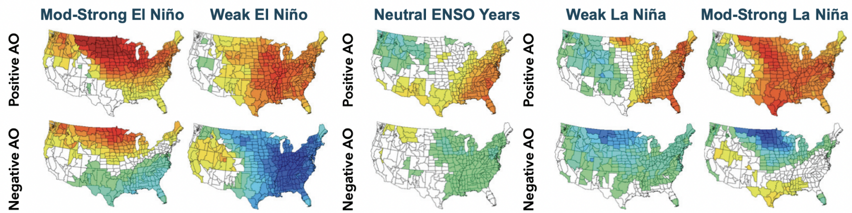
The Arctic Oscillation (AO) is a variation in the circulation pattern around the Northern Hemisphere from a faster west-to-east flow (positive phase AO) to one that is more north-to-south flow (negative phase AO). To boil it down into a short synopsis, the positive phase of the AO typically sees more stable weather with colder West Coast temperatures and warmer Central US and East Coast temperatures. On the other hand, a negative AO phase brings more chaotic precipitation (due to more troughing from the meridional jet stream flow) with near-neutral temperatures on the West Coast and widespread below-average temperatures to the East. A negative AO phase brings above-average precipitation to the West Coast and below-average precipitation to the East. The ENSO phase heavily impacts the AO, so keep that in mind.
North Atlantic Oscillation
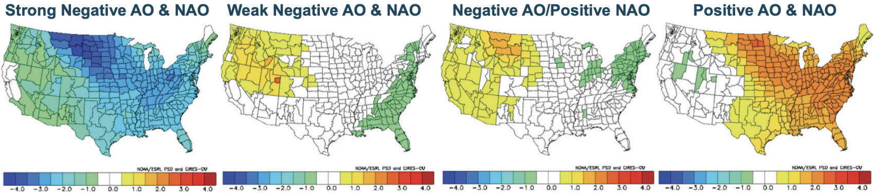
The North Atlantic Oscillation (NAO) is not very useful for US forecasts by itself, but when coupled with the AO, it has very clear consequences on temperatures. A strong negative phase in both the AO and NAO leads to below-average temperatures across the entire United States. Weak negative phases and a negative AO/positive NAO configuration yield above-average temperatures in the West, with colder temperatures in the East. A strong positive AO and NAO mean near-neutral West Coast temperatures and widespread above-average temperatures in the East.
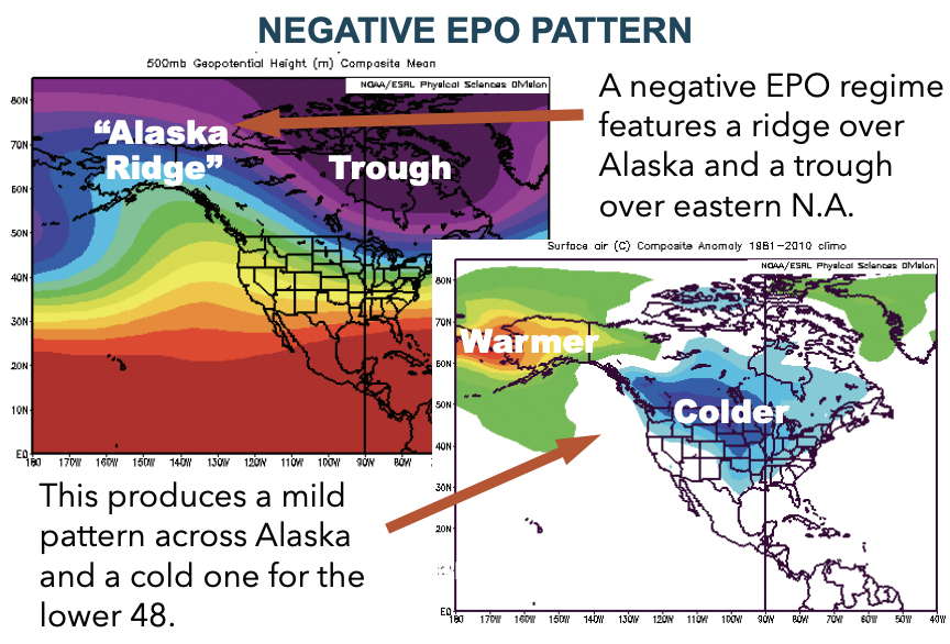
Eastern Pacific Oscillation
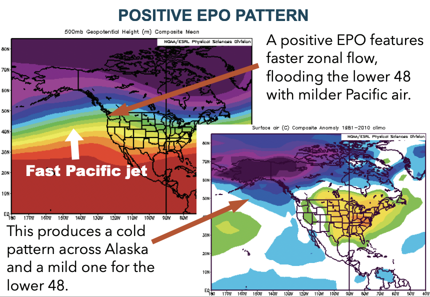
The Eastern Pacific Oscillation (EPO) has everything to do with the North American jet stream, which is hugely important for forecasting precipitation. The EPO allows more direct jet stream flow to the West Coast in a positive phase, delivering troughs, moisture, and storm energy to areas like the PNW, California, Wyoming, Utah, and Colorado. The negative EPO builds a large ridge in the northeastern Pacific Ocean, which causes the jet stream to divert far to the north before ushering in a polar air intrusion into the Northeast. With a negative EPO phase, the East Coast should expect to see above-average snowfall with below-average temperatures.
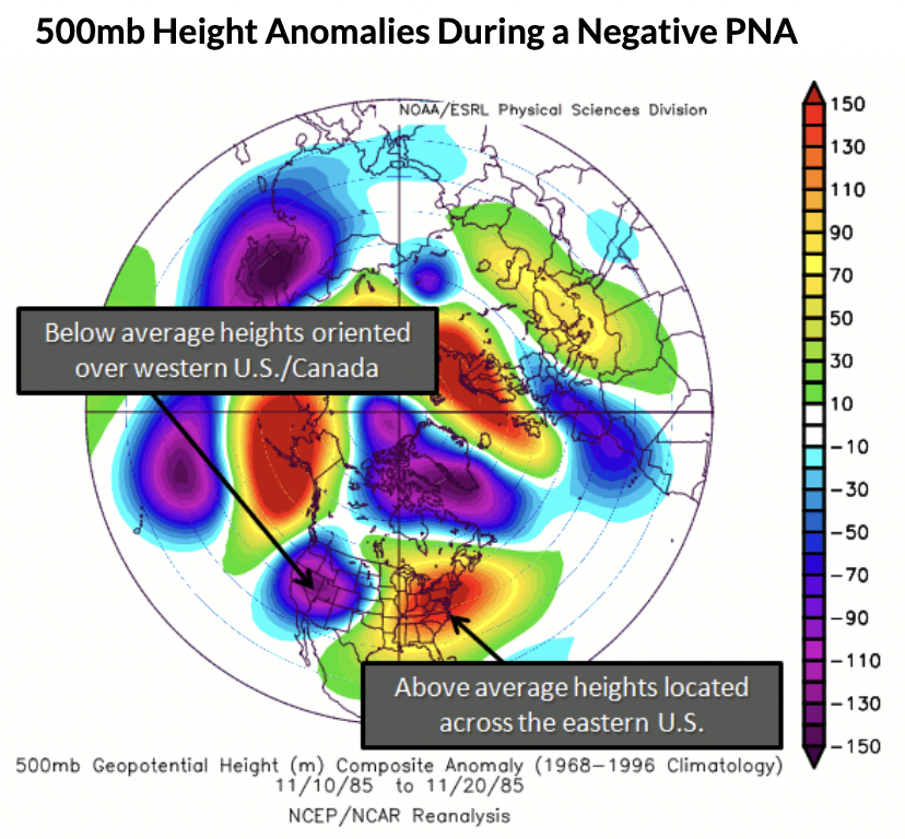
Pacific North American Oscillation
The Pacific North American Oscillation (PNA) strongly influences the storminess and temperature fluctuations in North America. Fortunately, the connections from phase to weather are extremely clear. In a positive phase, the PNA tends to produce stormier and colder weather on the East Coast (with warmer and dryer conditions to the West), and the negative phase brings stormy and cold weather to the West Coast (with warm and dry conditions to the East).
Have any questions about teleconnections? Ask them in the comments and I’ll answer them as quickly as possible!
Wow Clay, saweet article! So, for all of us dummies, does this mean there will be wicked extra GNAR this year?