Views of the Grand Tetons from Grand Targhee. photo: grand targhee
NOAA has issued a Winter Storm Watch for the Grand Teton mountain range of Wyoming including Grand Targhee & Jackson Hole ski resorts for tomorrow.
7-14″ of snow forecast tomorrow.
Teton snowpack currently at 94% of average to date.
Grand Targhee has seen 289″ of snowfall this winter and they have an 88′ snowpack.
Jackson Hole has seen 291″ of snowfall this winter and they have an 82″ snowpack.
Both resorts should break 300″ this week!
Snowfall forecast for WY. image: noaa, todayJackson Hole on Feb. 15th, 2016. photo: jackson hole
“An approaching storm system is likely to bring wintry conditions to areas west of the Continental Divide and high winds to southwest and central Wyoming beginning Wednesday night and continuing through Thursday.
Accumulating snow is likely in the mountains and valleys of western Wyoming, especially on Thursday. High wind over southwest and central Wyoming will increase Thursday morning and peak Thursday afternoon. Wind gusts over 60 mph are possible across a wide swath of Wyoming. Winds will generally be from the south to southwest.
Those traveling over the western passes, like Teton, Togwotee, and Salt River, should be prepared for deteriorating road conditions and visibility by Thursday morning. Commuters should plan to leave early in order to allow for the wintry conditions and for other delays. Motorists traveling I-80 and other roads and highways of southwest and central Wyoming should be prepared for possible cross-winds.
What/When: Snow across the western Wyoming mountains is expected to begin late Wednesday night and increase in intensity Thursday. South to southwest wind will increase Thursday morning over southwest and central Wyoming. The strongest wind speeds are likely during the midday and afternoon hours Thursday. The wind and snow will decrease Thursday evening into early Friday morning.
Amounts/Speeds:Total snowfall of 7 to 14 inches is possible in the Teton and Gros Ventre ranges. Some valley locations could see light accumulations, although warm temperatures may allow for rain to mix with snow in the valleys on Thursday. Wind speeds of 30 to 40 mph with gusts to 60 mph are possible across southwest and central Wyoming. Some gusts to 70 mph may be possible from Lander east to Casper.”
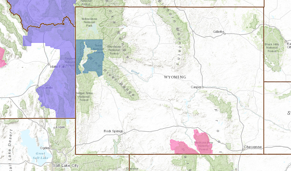
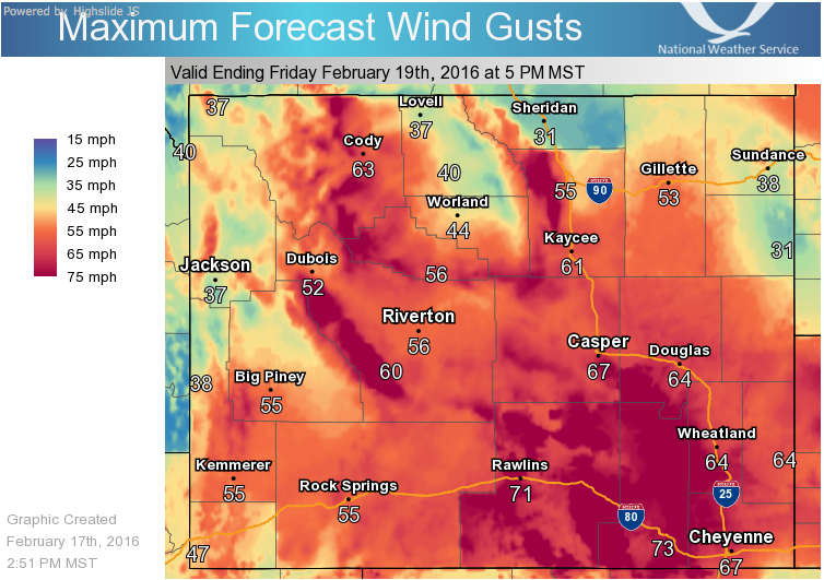
BLUE = Winter Storm Watch. Grand Targhee & Jackson are in the blue area. image: noaa, todaWind forecast. image: noaa, today
WINTER STORM WATCH for WYOMING:
URGENT - WINTER WEATHER MESSAGE
NATIONAL WEATHER SERVICE RIVERTON WY
311 PM MST WED FEB 17 2016

...SIGNIFICANT SNOW AND WIND EXPECTED IN THE WESTERN WYOMING MOUNTAINS
THURSDAY AND THURSDAY NIGHT...

.AN APPROACHING STORM SYSTEM WITH A STRONG COLD FRONT WILL LIKELY
PRODUCE A SIGNIFICANT SNOWSTORM FOR THE WESTERN WYOMING MOUNTAINS. SNOW
AND WIND WILL BE ON THE INCREASE EARLY THURSDAY AND CONTINUE
THROUGH THURSDAY NIGHT BEFORE ENDING. THE COMBINATION OF SNOW AND
WIND COULD CAUSE SIGNIFICANT IMPACT FOR THOSE PLANNING OUTDOOR
ACTIVITIES OR TRAVEL OVER AREA PASSES INCLUDING TETON...SALT
RIVER...TOGWOTEE AND SOUTH PASS.

TETON AND GROS VENTRE MOUNTAINS-

...WINTER STORM WARNING IN EFFECT FROM 2 AM THURSDAY TO 5 AM MST
FRIDAY...

THE NATIONAL WEATHER SERVICE IN RIVERTON HAS ISSUED A WINTER
STORM WARNING FOR THE TETON AND GROS VENTRE RANGE WHICH IS IN
EFFECT FROM 2 AM THURSDAY TO 5 AM MST FRIDAY. THE WINTER STORM
WATCH IS NO LONGER IN EFFECT.

* TIMING...SNOW WILL DEVELOP LATE TONIGHT AND MAY BE HEAVY AT
  TIMES THURSDAY THROUGH THURSDAY NIGHT.

* SNOW ACCUMULATION...7 TO 12 INCHES WITH LOCAL AMOUNTS OF 14
  INCHES ON SOME WESTERN FACING SLOPES.

* WIND AND VISIBILITY...SOUTH TO SOUTHWEST WIND OF 25 TO 35 MPH
  WITH GUSTS OF 45 TO 50 MPH MPH OVER THE EXPOSED RIDGES AND
  HIGHEST ELEVATIONS. WINDS WILL SHIFT TO THE WEST THURSDAY
  EVENING. THE COMBINATION OF SNOW AND WIND WILL REDUCE THE
  VISIBILITY TO NEAR ZERO AT TIMES.

* MAIN IMPACTS...TRAVEL WILL LIKELY BECOME DIFFICULT OVER MOUNTAIN
  PASSES...INCLUDING TETON AND TOGWOTEE PASSES....AS ROADS BECOME
  SNOW PACKED AND SLICK WITH POOR VISIBILITY. BEFORE
  TRAVELING MOTORISTS SHOULD CHECK THE LATEST ROAD CONDITIONS BY
  VISITING WYOROAD.INFO OR BY DIALING 5 1 1. BACKCOUNTRY TRAVELERS SHOULD
  ALSO BE ALERT FOR THIS SIGNIFICANT STORM WITH PLENTY OF WIND AND
  SNOW.
Teton snowpack sitting at 94% of average to date. image: nws, today