The National Weather Service has issued a Winter Storm Warning for CO, UT, and WY through October 3rd at 12:00am. A strong cold front is moving through the area, which will allow snow to persist throughout the day today.
Up to 12″ of additional snowfall for CO Today.
NOAA Has Issued A Winter Storm Warning For:
Colorado
Utah
Wyoming
NOAA Has Issued A Winter Weather Advisory For:
Colorado
Wyoming
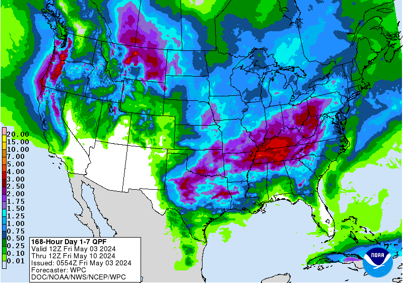
7 day snowfall totals. Image: Tropical Tidbits7 day precipitation totals. Image: NOAA
Snow levels are expected to hover around 7,000ft today, but they will be around 8,000ft on the I-70 Corridor in Colorado.
Additional Storm Info:
Heavy mountain snowfall will continue today. Image: NOAA Grand Junction, COExpected snow totals. Image: NOAA Denver, CO
Colorado: Up To 12″ of Additional Snowfall Through Today
Additional snow accumulations of 5 to 10 inches, with
localized amounts up to 12 inches, are expected.
- NOAA Denver, CO
Highs on Monday. Image: NOAA Salt Lake City, UTIt’ll be a cool and showery start to the week across much of Utah and southwest Wyoming. Image: NOAA Salt Lake City, UT
Utah: 2-4″ of Additional Snowfall Through Today
Additional snow accumulations of 2 to 4 inches
expected, for storm total accumulations of 6 to 12 inches.
- NOAA Salt Lake City, UT
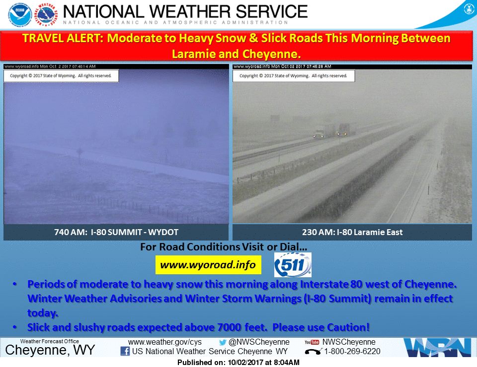
Moderate to heavy snow has developed across southeast Wyoming, mainly along and south of Interstate 80 from west of Laramie towards Cheyenne. Image: NOAA Cheyenne, WY
A wintry mix of rain and snow showers will be possible across western and central Wyoming this morning. Image: NOAA Riverton, WY
Wyoming: 4-8″ of Additional Snowfall Through Today
Additional snow accumulations of 4 to 8 inchesare
expected.
- NOAA Cheyenne, WY
6-10 day temperature outlook. Image: NOAA6-10 day precipitation outlook. Image: NOAA
CO Winter Storm Warning:
URGENT - WINTER WEATHER MESSAGE
National Weather Service Denver CO
358 AM MDT Mon Oct 2 2017
...Wintry weather to continue over the northern Coloradomountains today trough this evening...
.A weather system being driven by a powerful Pacific jet stream
will remain over Colorado today, bringing widespread
precipitation to the north central Colorado mountains. Snow levelsare expected around 7000 feet near the Wyoming border, and
around 8,000 feet along the I- 70 Corridor. The storm system is
expected to move out of the state this evening with snow gradually
ending.
Rabbit Ears Pass-
Rocky Mountain National Park and the Medicine Bow Range-
Including the cities of East Slopes Park and Northern Gore
Ranges, Gore Pass, Rabbit Ears Pass, Cameron Pass,
Laramie and Medicine Bow Mountains, Rabbit Ears Range,
Rocky Mountain National Park, and Willow Creek Pass
358 AM MDT Mon Oct 2 2017
...WINTER STORM WARNING REMAINS IN EFFECT UNTIL MIDNIGHT MDTTONIGHT...
* WHAT...Periods of Moderate to Heavy snow occurring. Plan on
difficult travel conditions, including during the morning
commute. Additional snow accumulations of 5 to 10 inches, with
localized amounts up to 12 inches, are expected.
* WHERE...Rabbit Ears Pass and Rocky Mountain National Park and
the Medicine Bow Range.
* WHEN...Until midnight.
* ADDITIONAL DETAILS...Travel conditions will be slow and hazardous today through this evening due to icy conditions and snow pack roads. Hunters, motorists and other outdoor
interests should take note of the prolonged period of winter
weather, and be prepared for much colder temperatures and accumulating snow.
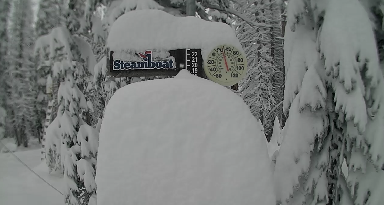
Steamboat Resort Right Now. Image: Steamboat Webcam