Yesterday, NOAA had a Winter Storm Watch issued for the southern Sierra and not the northern Sierra. Today, they’ve extended that Winter Storm Watch to include the northern Sierra and Lake Tahoe. The watch is in effect from Friday afternoon until Saturday morning.
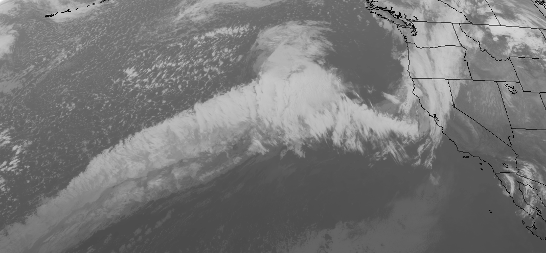
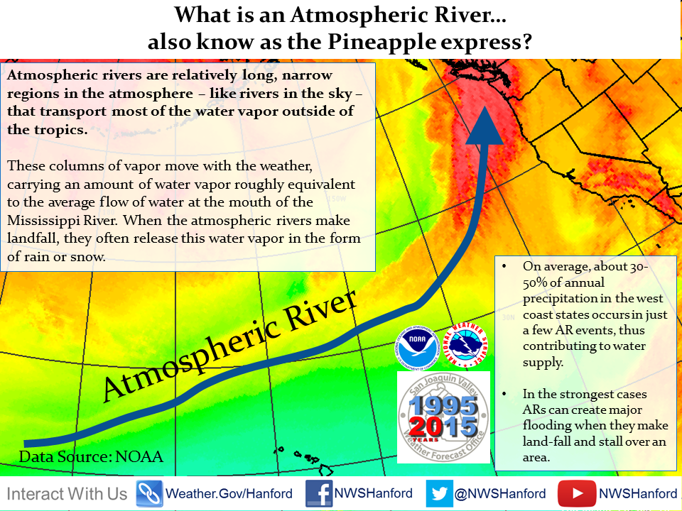
Snow levels are going to be high and this storm is going to show up with a lot of wind and rain before turning to snow.
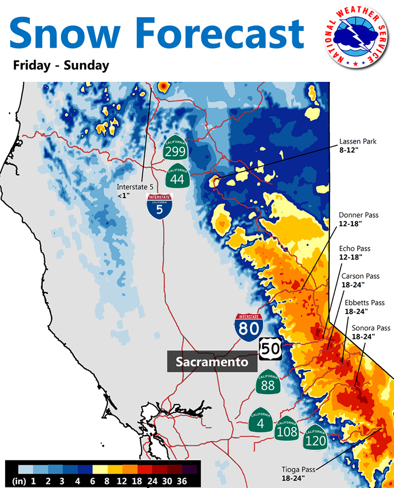
1-2 feet of snow is forecast above 8,000-feet, 6-12″ forecast above 7,000-feet, 6″ forecast below 7,000-feet.
* SNOW ACCUMULATIONS: 1 TO 2 FEET ABOVE 8000 FEET...INCLUDING
  CARSON PASS AND THE MOUNT ROSE HIGHWAY SUMMIT. 6 TO 12 INCHES
  BETWEEN 7000 AND 8000 FEET...INCLUDING DONNER PASS AND ECHO
  SUMMIT. UP TO 6 INCHES BELOW 7000 FEET.
Snow levels will start out as high as 8,500-feet on Friday before lowering down to 6,000-feet by Saturday morning.
* SNOW LEVELS: 8000 TO 8500 FEET LATE FRIDAY AFTERNOON...THEN
  LOWERING TO 5500 TO 6000 FEET BY SATURDAY MORNING.
Winds will be howling up to 100mph.
* WINDS: SOUTHWEST 20 TO 30 MPH WITH GUSTS TO 50 MPH IN THE LOWER
  ELEVATIONS WITH SIERRA RIDGE GUSTS NEAR 100 MPH.
Saturday will likely be a day with upper mountains closed and lower mountains very soggy. Sunday, though, could be spectacular up high. Granite Chief? Palisades? Mt. Rose? boom.
Snowfall totals as of today in CA:
- Sugar Bowl = 337 inches
- Northstar = 282 inches
- Kirkwood = 281 inches
- Squaw Valley = 274 inches
- Heavenly = 220 inches
- Mammoth = 188 inches
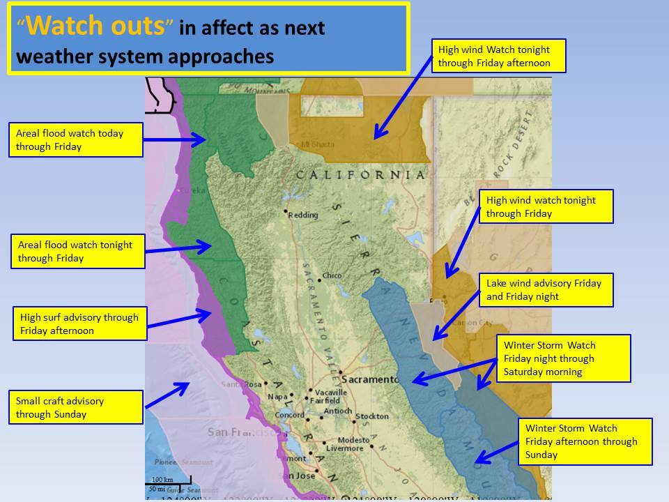
WINTER STORM WATCH for CALIFORNIA:
URGENT - WINTER WEATHER MESSAGE
NATIONAL WEATHER SERVICE RENO NV
249 AM PST THU JAN 28 2016

GREATER LAKE TAHOE AREA-
INCLUDING THE CITIES OF...SOUTH LAKE TAHOE...TRUCKEE...
INCLINE VILLAGE

...WINTER STORM WATCH IN EFFECT FROM FRIDAY AFTERNOON THROUGH
SATURDAY MORNING...

THE NATIONAL WEATHER SERVICE IN RENO HAS ISSUED A WINTER STORM
WATCH...WHICH IS IN EFFECT FROM FRIDAY AFTERNOON THROUGH SATURDAY
MORNING.

* TIMING: STRONG WINDS...RAIN AND SNOW WILL MOVE INTO THE TAHOE
  BASIN FRIDAY AND CONTINUE THROUGH SATURDAY MORNING. HEAVY SNOW
  IS LIKELY FRIDAY NIGHT AND SATURDAY MORNING.

* SNOW LEVELS: 8000 TO 8500 FEET LATE FRIDAY AFTERNOON...THEN
  LOWERING TO 5500 TO 6000 FEET BY SATURDAY MORNING.

* SNOW ACCUMULATIONS: 1 TO 2 FEET ABOVE 8000 FEET...INCLUDING
  CARSON PASS AND THE MOUNT ROSE HIGHWAY SUMMIT. 6 TO 12 INCHES
  BETWEEN 7000 AND 8000 FEET...INCLUDING DONNER PASS AND ECHO
  SUMMIT. UP TO 6 INCHES BELOW 7000 FEET.

* WINDS: SOUTHWEST 20 TO 30 MPH WITH GUSTS TO 50 MPH IN THE LOWER
  ELEVATIONS WITH SIERRA RIDGE GUSTS NEAR 100 MPH.

* IMPACTS: DANGEROUS CONDITIONS FOR RECREATIONAL ACTIVITIES AND
  TRAVEL OVER MOUNTAIN PASSES. STRONG WINDS MAY DAMAGE DROUGHT
  STRESSED TREES WITH POWER OUTAGES POSSIBLE.