Snow is finally forecast to drop into the Northeast USA!
NOAA has issued a Hazardous Weather Outlook for the Northeast (see below).
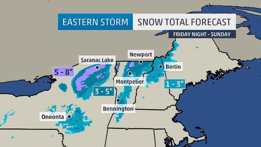
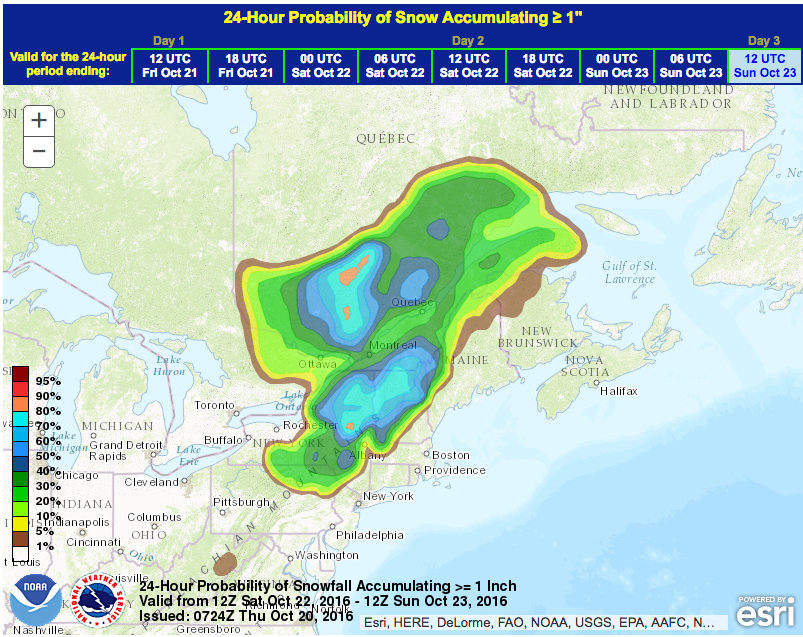
NOAA & The Weather Channel are forecasting snow for New York, Vermont, New Hampshire, and Maine.
Some locally heavy snow is possible
over the higher summits of the Adirondacks and Green Mountains
Saturday night.

Some locally heavy snowfall is possible Sunday over the higher summits
of the Adirondacks and Green Mountains on Sunday. - NOAA Burlington, VT today
Snow levels will be relatively high with this storm:
A HEAVY WET SNOWFALL IS POSSIBLE OVER THE
HIGHER SUMMITS OF THE ADIRONDACKS AND GREEN MOUNTAINS FROM LATE
SATURDAY THROUGH SUNDAY. - NOAA Burlington, VT today

Up to 8″ of snow are forecast.
New York and Vermont are forecast to get the most snow.
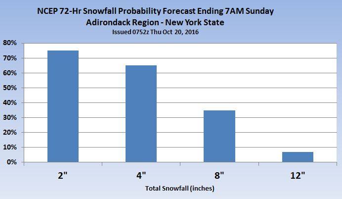
“Still looks like an elevation event snow this weekend for parts of Upstate New York, mainly the High Peaks of the Adirondacks, but parts of the Catskills could also see snow. In addition, the Northeast Kingdom in Vermont will see snow at higher elevations. Below is the latest official forecast and the NCEP probability of at least 8″ of snow through Sunday morning.” – Tom Niziol/Weather Channel, today

Killington, VT is the ski resort scheduled to open earliest in the Northeast.
2016/17 Opening Dates for Northeast USA Ski Resorts:

HAZARDOUS WEATHER OUTLOOK for NORTHEAST USA:
HAZARDOUS WEATHER OUTLOOK
NATIONAL WEATHER SERVICE BURLINGTON VT
418 AM EDT THU OCT 20 2016

NORTHERN ST. LAWRENCE-NORTHERN FRANKLIN-EASTERN CLINTON-
SOUTHEASTERN ST. LAWRENCE-SOUTHERN FRANKLIN-WESTERN CLINTON-
WESTERN ESSEX-EASTERN ESSEX-SOUTHWESTERN ST. LAWRENCE-GRAND ISLE-
WESTERN FRANKLIN-ORLEANS-ESSEX-WESTERN CHITTENDEN-LAMOILLE-CALEDONIA-
WASHINGTON-WESTERN ADDISON-ORANGE-WESTERN RUTLAND-WINDSOR-
EASTERN FRANKLIN-EASTERN CHITTENDEN-EASTERN ADDISON-EASTERN RUTLAND-

THIS HAZARDOUS WEATHER OUTLOOK IS FOR NORTHERN NEW YORK...CENTRAL
VERMONT...NORTHEAST VERMONT...NORTHWEST VERMONT AND SOUTHERN
VERMONT.

.DAY ONE...TODAY AND TONIGHT.

RAIN IS EXPECTED TO DEVELOP ACROSS THE REGION TODAY AND CONTINUE
INTO TONIGHT.

.DAYS TWO THROUGH SEVEN...FRIDAY THROUGH WEDNESDAY.

A WIDESPREAD AND LONG DURATION RAINFALL EVENT WILL CONTINUE FRIDAY
THROUGH SUNDAY. RAINFALL AMOUNTS FROM THURSDAY THROUGH SUNDAY ARE
EXPECTED TO RANGE FROM 2 TO 4 INCHES. GIVEN THE RECENT DRY
ANTECEDENT CONDITIONS AND LONG DURATION EVENT, WIDESPREAD HYDRO
ISSUES ARE NOT EXPECTED. MINOR URBAN OR STREET FLOODING IS
POSSIBLE ASSOCIATED WITH LEAVES CLOGGING STORM DRAINS.

COLDER AIR ALOFT WILL MOVE INTO THE REGION LATE SATURDAY AND
CONTINUE INTO SUNDAY. RAIN WILL CHANGE TO SNOW OVER THE HIGHER
ELEVATIONS OF THE ADIRONDACKS AND GREEN MOUNTAINS LATE SATURDAY
AND SATURDAY NIGHT. A HEAVY WET SNOWFALL IS POSSIBLE OVER THE
HIGHER SUMMITS OF THE ADIRONDACKS AND GREEN MOUNTAINS FROM LATE
SATURDAY THROUGH SUNDAY.