The Australian Bureau of Meteorology (BOM) has reiterated its La Niña watch for the Australian winter and spring season. While the El Niño–Southern Oscillation (ENSO) is currently neutral, early signs hint at a La Niña event forming in the Pacific Ocean later in 2024. A La Niña watch does not guarantee that a La Niña will develop. There is about an equal chance of neutral ENSO conditions in the same outlook period.

Sea surface temperatures (SSTs) in the central Pacific have been steadily cooling since December 2023. Climate models suggest that SSTs in the central tropical Pacific are likely to continue to cool over the coming months and four of seven models suggest SSTs are likely to remain at neutral ENSO levels, with the remaining three models showing SSTs cooling to La Niña levels from August. In its report six weeks ago, these three models were showing La Niña levels from July.
Meanwhile, the Indian Ocean Dipole (IOD) is still in neutral. The most recent four weeks have seen the IOD index within neutral thresholds, with the latest week just below the positive IOD threshold (+0.40 °C). It is important to remember that predictability of the IOD is low at this time of year and with SSTs for the last 12 months at the highest levels they have ever been, historical comparisons based on past ENSO or IOD events may not be reliable. Six weeks ago it was estimated that IOD could be mildly positive by May but this has not eventuated. The average of the models now predicts a neutral IOD for the Australian winter and spring.

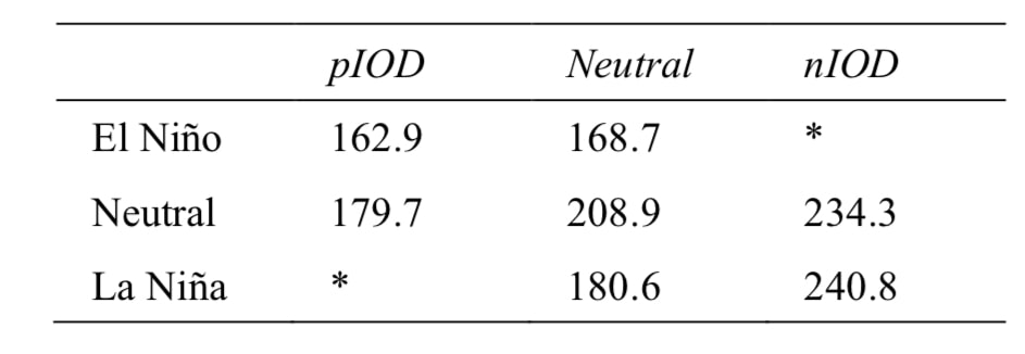
What does a La Niña year combined with a neutral IOD mean for snowfalls this coming ski season? Typically La Niña years are associated with increased precipitation but not necessarily increased snowfall, as oftentimes temperatures during La Niña can be too high, and hence precipitation may fall as rain even at higher elevations, which can decrease snow depths. Statistically, roughly 60% of La Niña years have had a lower maximum snow depth than average. This has happened more frequently in recent decades as a result of climate change, with seven of the past eight La Niña years having lower maximum snow depths. Historically, neutral years have provided better snow depth than either El Niño or La Niña years. Nevertheless, snowfall-wise a La Niña year is better than an El Niño year, so this in itself is good news for Australian snow fields.

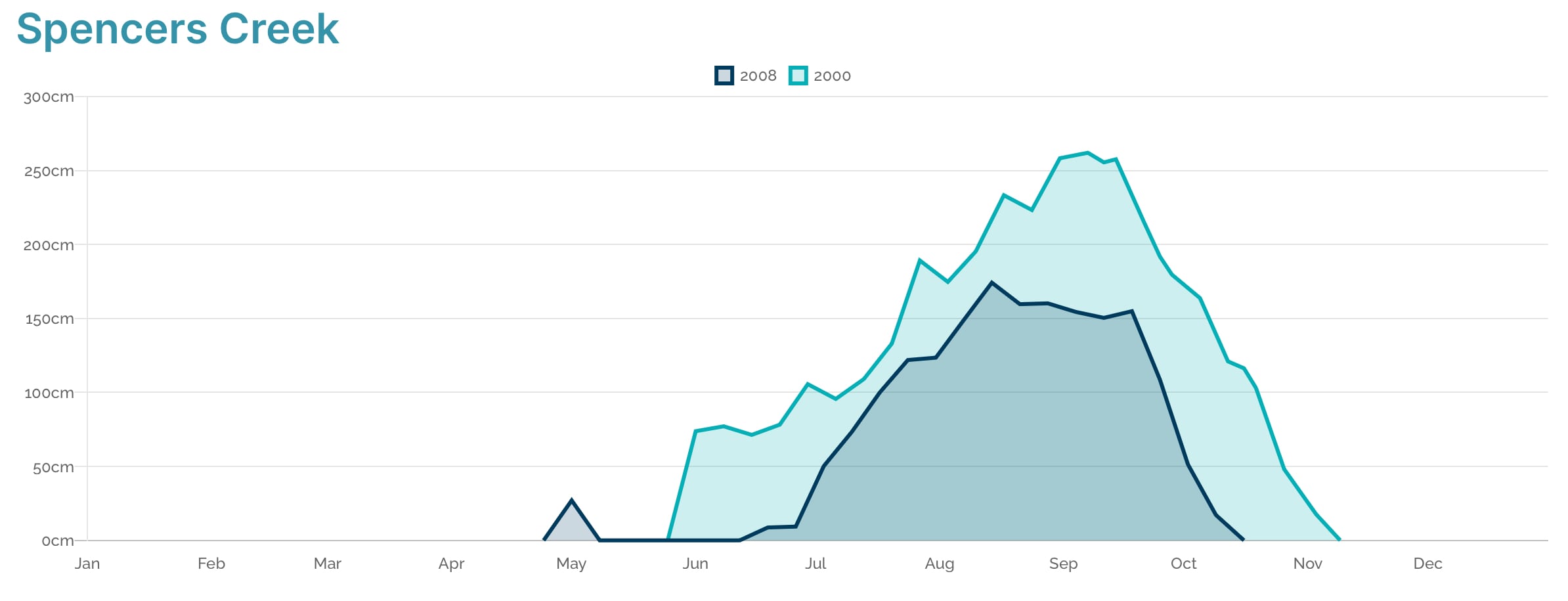
According to BOM, a neutral IOD in combination with La Niña has occured in the winters of 1970, 1973, 1988, 1998, 1999, 2000, and 2008. Using the most recent two years shows just how big the range can be with 2000 having a peak snowdepth of 262 cm (103 inches) and 2008 an peak snowdepth of only 174.2 cm (69 inches). The natural snow cover in 2000 also started much earlier than in 2008 and lasted all the way until November. While this makes a prediction on this year’s snow cover hard with such a high variance, an average of 180.6 cm (71 inches) for those seven years it is still a better outlook for 2024 than the 164 cm average under a positive IOD we had calculated last month. So we are hoping that the shift into neutral for the winter will have a positive impact on this year’s ski season. If La Niña does not develop until spring, this could make for an even better season. Keep up the snow dance!
