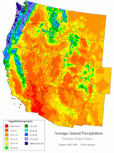
The Pacific Northwest and British Columbia consistently finish the season at the top of the snowfall charts every year. Averaging the most snow in North America, it’s no surprise. Looking at the chart below from the Western Region Climate Center, it’s pretty easy to see that the Pacific Northwest gets more rain than anywhere else in the West (British Columbia is not included in this chart, but they receive as much or more precipitation than Washington):

So what is the cause of the significant difference in precipitation totals between, say, Washington and Colorado? Why do regions near the coast get so much snow?
The primary answer is moisture. To distill it down into straightforward terms, the Cascades and BC Coastal Ranges are closer to a source of atmospheric moisture (the ocean).
In the winter, ocean waters are (usually) warmer than their surrounding atmospheric environment. This leads to evaporation, turning liquid water in the ocean into water vapor in the atmosphere. This water vapor can then be trapped in storm systems, where complex vertical forcing mechanisms cause the air to cool, condense, and fall as rain or snow.
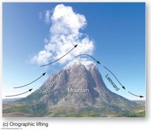
However, snow can also fall through something called orographic lift (also sometimes referred to as “upslope flow”). The same concepts behind low-pressure system vertically forced precipitation are at work with orographic lift. When air is blown against the side of a mountain, it rises along the slopes of the mountain and cools. Since cold air can hold less water than warm air, the relative humidity increases, further saturating the air. Eventually, the air cools enough that it reaches 100% relative humidity. However, the air wants to keep rising and cooling, so it does! Since air can’t hold more than its theoretical maximum capacity (100% relative humidity), moisture must fall as rain or snow.

The reason mountains near the Pacific Coast get so much snow; they have uninterrupted supplies of moisture just a few miles away. Saturated air can hammer these mountains for days at a time, dumping feet of snow nonstop. However, for example, Colorado has thousands of miles between it and the ocean. By the time storm systems reach Colorado, lots of moisture has already been forced out of the air by mountains and dynamically driven precipitation (jet stream, vorticity, etc.). Check out the chart below of average relative humidity in the US. Notice how Colorado is consistently much drier than Washington every month of the year:

Simply put, there’s less water available to fall as snow. This is the easy-to-blame reason why the Pacific Northwest gets significantly more precipitation than Colorado. However, there is a more complex reason these regions get so much snow.
Since the ocean is warmer in the winter, high-pressure areas tend to develop over the Pacific Coast and the western US. Conversely, this causes the eastern US to be, on average, colder and stormier due to troughing Rossby waves. Considering the clockwise rotation of high-pressure systems and the counter-clockwise rotation of low-pressure systems, the jet stream hooks up through the PNW then down through the plains. On average, atmospheric moisture and instability will move with the jet stream, so on average, more storminess will pass through the Pacific Northwest than Colorado or Utah, for example. This pattern can break when strong troughs move through the west. However, on average, considering the basics of atmospheric thermodynamics, the jet stream will be focused in the Pacific Northwest.
These two factors – moisture availability and jet placement – explain why the Pacific Northwest gets so much snow, whereas areas in the intermountain west like Nevada, Utah, and Colorado, for example, receive much less.
