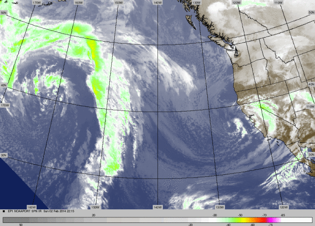
Here is a shot of the satellite of the system sliding down the coast yesterday. Tahoe was sitting in a weak deformation zone that set up over our area. A deformation zone is defined as ” an area in the atmosphere where winds converge on one axis and diverge on another”. This creates enhanced areas of lifting causing concentrated areas of precipitation. The low tracked too far west for us to normally get more then a dusting, but we caught a lucky break and managed to squeak out a few inches.
Quick recap on this weeks pattern change. The ECMWF actually accurately predicted a storm beyond the 10 day period which is a minor miracle as far as this season and the models are concerned. It was pretty bold to go along with the solution since it was the first storm to come off the Pacific since December 11th 2012. From the snow perspective the storm was a disappointment, but from the water perspective no complaints.
We managed to soak the ground and lay down some dense wet snow, which hopefully gives us something to build upon. As for now we’re in an inside slider pattern with the ridge sitting at 135 degrees west. Seems like a broken record, because this is the pattern we have been sliding in and out of since November. The harsh reality is the Eastern Pacific Oscillation (EPO), that has been dominating our weather since January of 2013 has been shifting between 120-145 degrees W for 13 months now. Since we are sitting in an inside slider pattern once again you’re probably asking what has changed? The ridge was split in half pinching the stronger half up into Alaska and Yukon. The ridge off our coast is now a former version of itself which should allow for a much more progressive pattern for the west coast in the weeks to come.
Short term forecast. Three shortwaves this week before the next pattern change. First one for today is moisture starved and looks to track too our east, so chance of snow showers. The next one comes in on Wednesday night so we could have a few inches by Thursday morning. On Thursday a back door cold front combined with a short wave hitting the Northwest might draw in some moisture, the exact track and timing of the moisture is still to be determined, which could effect the totals .This shortwave bears watching because it might turn into several inches due to the strong dynamics associated with the cold front. This feature definitely will reinforce the cold snap and further drop temperatures below average.
BRIEF SHORTWAVE RIDGE BUILDS INTO THE AREA FRIDAY NIGHT, BEFORE A
MILD MOISTURE TAP REACHES THE PACIFIC NORTHWEST COAST, ATTRIBUTED TO
A THIN ATMOSPHERIC RIVER ORIGINATING WEST OF THE HAWAIIAN ISLANDS. - NOAA Reno, NV
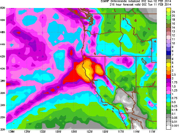
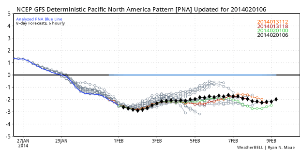
As for the next significant pattern change. Here is the total precipitation forecast for ECMWF up to February 11th. The main storm track is pointed just to our north in this model. Notice the thin atmospheric river that stretches west of Hawaii. Quick description: The ridge gets pinched off into the Bering Sea, while a low develops in the Gulf of Alaska forcing the jet stream to undercut the low. The low pressure anomaly in Alaska is supported by the moderate negative Pacific North American Pattern (PNA.) Here is the PNA index up to the 9th of February.
So it looks like we’re set up for a heavy snow event for the Sierra, with the first fetch of moisture hitting the west coast on Saturday night. Here is the one issue: The low is setting up off the Northern British Columbia Coast, a little too far north keeping us on the southern edge of the jet stream which will mean dramatically fluctuating snow levels. Worst case scenario the bulk of the precipitation misses us to the north. What typically happens in this scenario is amplification and deamplification of the ridge causes the jet to shift north and south erratically. We should get hit by a decent bulk of these storms but the snow levels are going to be a concern.
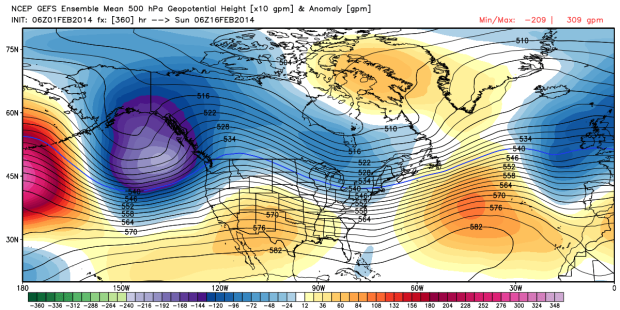
This is the ensemble for the Global Forecasting System (GFS) for February 16th. As poor as the track record is for the GFS this is a good indicator for the pattern to continue beyond the middle of February. If I were to get super critical with this chart it looks like the low is too far west, which would keep the jet stream even further to our north. We need the low to be south of the Columbia River and as close to the coast as possible and it would become a major snow event for the Sierra. Once again it all comes down to geographic’s. It looks like the jet starts out pointed at us to start late Saturday night or early Sunday morning. With cold air in place it will start as snow down to the lower levels before the snow levels slowly rise . Then the jet shifts to the north for a couple of days, raising snow levels even more, before the jet drops back south. These are the type of cycles that cause serious hydrology issues for California in normal circumstances. Maybe we can put a dent in California’s horrendous drought.


