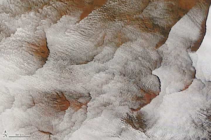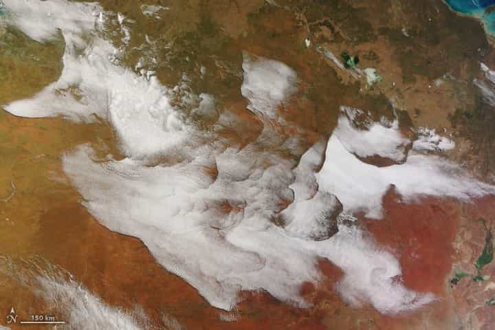
An unusual collection of clouds appeared over the interior of Australia on the morning of July 5, 2023. The Moderate Resolution Imaging Spectroradiometer (MODIS) on NASA’s Terra satellite captured this image of the stunning display, which stretched for more than 1,000 kilometers (600 miles) over Western Australia and the Northern Territory.
- Related: NASA: El Niño Returns
Several experts in cloud dynamics who looked at the image found the patterns to be both odd and fascinating, and they could not say with certainty what caused the complex formations based on the image alone. However, meteorological observations from that time offer clues into what may have been going on.
“We know that gravity wave cloud fields are quite common in a stable atmosphere,” said Yi Huang, atmospheric scientist at the University of Melbourne. According to temperature profile data, the atmosphere on the morning of July 5 was very stable and well-stratified, with a sharp temperature inversion at the top of the atmospheric boundary layer. Disturbances, which can occur when air encounters small ridges and valleys, will produce wave textures in the clouds that look like ripples on a pond. Indeed, in the detailed view below, we see these finer-scale textures within the large clouds.
On the western edge of the formation, the cloud edges seem to mirror some of the major topographical features below. That terrain, Huang speculated, might have set off a series of waves with longer wavelengths. Those waves could have produced the crisp cloud boundaries, where sinking, warming air going into the wave troughs has caused the clouds to evaporate.
The large-scale features bear some resemblance to fallstreak clouds, said atmospheric scientist Claire Vincent, also of the University of Melbourne. These clouds have circular or elliptical boundaries and form when clouds of supercooled water droplets disintegrate from the inside out. However, she noted that the phenomenon typically occurs higher in the atmosphere, whereas the clouds spotted over Australia were warmer, lower-level stratocumulus clouds.
The atmospheric spectacle seems to have been as fleeting as it was fascinating. Geostationary satellite views showed the cloud field and its distinct edges forming overnight, then disappearing by late morning, said Huang. That’s when heat radiating from the ground typically destabilizes the lower atmosphere.
This post first appeared on NASA Earth Observatory. NASA Earth Observatory images by Wanmei Liang, using MODIS data from NASA EOSDIS LANCE and GIBS/Worldview. Story by Lindsey Doermann.
