Hot on the heels of its highly anticipated U.S. winter forecast, The Farmers’ Almanac has just released its forecast for Canada. The forecast predicts a dynamic winter season for 2024-2025, influenced by La Niña conditions.
Regional Breakdown:
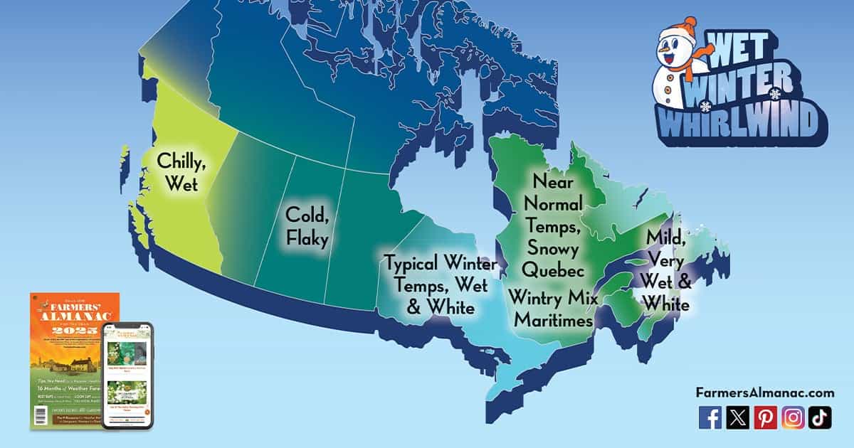
Prairies and Great Lakes:
Cold Temperatures: The coldest temperatures are anticipated from the Prairies into the Great Lakes region. The most significant cold outbreak is expected in the final week of January into early February, with frigid Arctic air causing a sharp temperature drop.
Snowfall: The Prairies have the best chances for a white winter, making it a prime location for winter sports enthusiasts.
Quebec:
Snow vs. Rain: Quebec is expected to experience more snow than rain overall, with a significant storm predicted in mid-February. This could provide excellent conditions for skiing and snowboarding.
Ontario:
Mixed Precipitation: Ontario will see a mix of snow and rain, with the eastern third of Canada, including Ontario, expecting above-normal precipitation. This mix could impact winter sports conditions, depending on the timing and type of precipitation.
British Columbia:
Wet Conditions: British Columbia is forecasted to have a wet winter. However, this could translate into substantial snowfall in the mountainous regions, benefiting ski resorts.
Newfoundland and Labrador:
Wet Winter: These regions are expected to have a wet winter with above-normal temperatures, resulting in more slushy conditions rather than consistent snow cover.
Important Dates:
The final week of January is highlighted for potential heavy precipitation and strong winds across the eastern half of Canada. Specific dates to watch are January 20-23 and 24-27, which may bring significant snow, rain, sleet, and ice.
This forecast suggests that while many regions will experience cold and snowy conditions favorable for winter sports, others will see a mix of precipitation types, potentially impacting snow quality and availability.
The full press release is below:
Farmers’ Almanac Winter 2025 Extended Weather Forecast For Canada
Farmers’ Almanac’s winter weather forecast for Canada calls for a season of rain and snow with little downtime. Here are some important dates to keep in mind and related information that may come in handy.
The astronomical start of winter begins with the winter solstice on Saturday, December 21, 2024. However, this doesn’t mean that winter weather will wait until this date to make itself known.
La Niña is expected to develop and last throughout the season this winter. If we blend the effects of La Nina into our proprietary formula, the winter of 2024-25 should see below-normal temperatures for about two-thirds of the nation, from east of the Rockies to Ontario.
Winter temperatures will be coldest from the Prairies into the Great Lakes region. The coldest outbreak of the season will come during the final week of January into the beginning of February, when frigid Arctic air brings a sharp plunge in temperatures, especially across the Prairies. Near-to-above-normal temperatures are expected across Quebec and the Maritimes. British Columbia will be unseasonably chilly.
Wet Winter Whirlwind? How About Snow?
Above-normal precipitation is expected over the eastern third of Canada, especially around the Great Lakes. According to our long-range outlook, the Newfoundland and Labrador regions should experience a wet winter overall with some snow, but with above-normal temperatures predicted, most of this precipitation should be wet, mushy, and slushy.
Quebec should see more white than wet overall this winter, with a decent-sized storm predicted for the middle of February. Ontario’s winter will be filled with a whirlwind of snow and rain, with the best chances of a white winter being in the Prairies.
British Columbia is predicted to have a wet winter, hopefully resulting in lots of snow in the mountains for skiers.
Dates To Remember
We are “red-flagging” the final week of January over most of the country’s eastern half because of a very active storm track that we expect will deliver frequent bouts of heavy precipitation and strong, gusty winds. We especially highlight the time frames from January 20 to 23 and 24 to 27, which may bring copious snow, rain, sleet, and ice.