CFS (Coupled Forecast System) February 1st-18th showing 6″ of liquid for Tahoe:
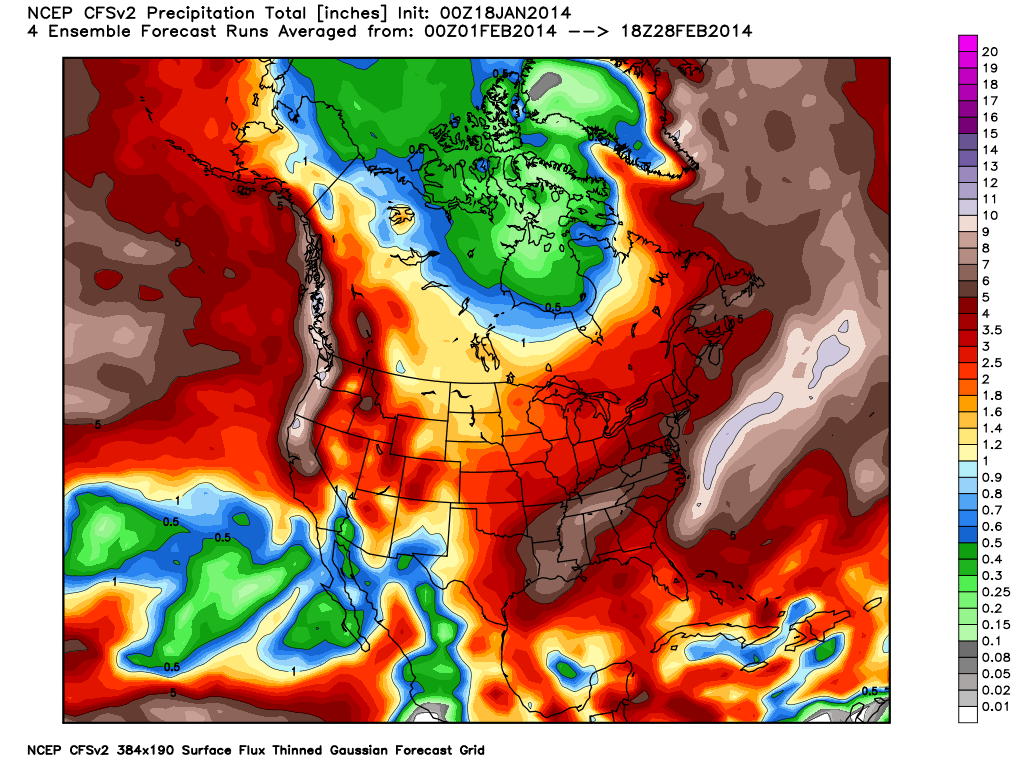
What is interesting in this chart, notice how the Hudson Bay area up in Canada gets very little precipitation. Normally a Hudson Bay low (which means they would be getting storms) acts as a blocking pattern for the West coast. The East coast looks relatively dry as well, while it dumps out in the Atlantic. This is a reinforcing sign that the long wave pattern is opening up with a ridge for the East coast and a trough out over the Atlantic. I will get to the teleconnections that support this pattern in a moment. As far as Tahoe is concerned 6″ of liquid during the first week of February alone would not be unlikely. That would be five feet of snow, depending on where the snow and rain line ends up. Does January end with a storm? Here is a shot of the ECMWF (European Centre for Medium-Range Weather Forecasts) control for the 28th of January.
This chart is almost identical to what it was showing a few days ago except for the timing was for the 26th. It’s like throwing darts as far as the timing, but there is a possibility for a storm breaking through the ridge between the 28th and the 31st of January. If this model is accurate it would end up being a 2 foot plus storm on the crest. The GFS (Global Forecast System)1 has a trough off of our coast for the 31st.
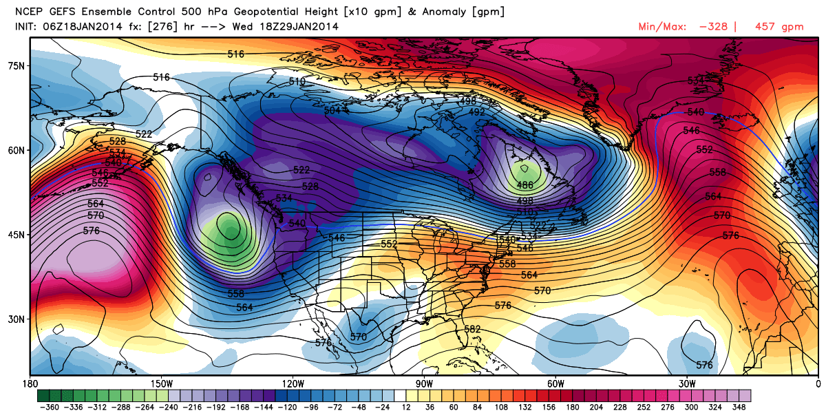
I’m not quite buying into this solution just yet. I think the Euro wins out and we get a storm to break through the ridge versus a trough being carved out. Either way they both show a storm before months end. I think the GFS is 2 or 3 days ahead of itself and we should start to carve a trough out around the 2nd of February. It’ll be very interested to see how pattern evolves for the first week of February.
The questions are:
How far does the EPO (ridge) retrograde to the west?
How far to the north does its axis form? How amplified does it become?
Does it become negatively tilted which there are signs of as well?
Or the scenario we are all fearing and it builds back in again?
I will go into detail on ridge orientation along its axis once it becomes more clear what solution we are going to end up with. As far as a significant pattern change, all the models seem to be in agreement on the retrogression of the EPO, and they are flip flopping like crazy which is also a good sign. The GFS and ECMWF long range outlook for the first week of February are showing similar solutions which involve storms, for the for the first time all season. Confidence on the exact details is low, confidence on the pattern change itself is growing stronger. Teleconnections Back to the analysis of the CFS chart. An Atlantic trough and east coast ridge supports a west coast trough. Well there finally is teleconnection support for this set up. A positive NAO (North Atlantic Oscillation) which supports a ridge for the East. 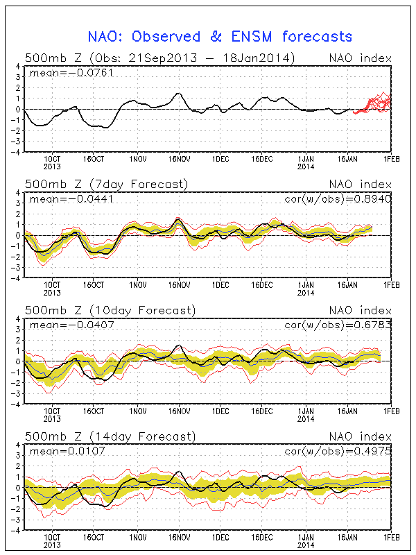
A negative PNA which supports a west coast trough. 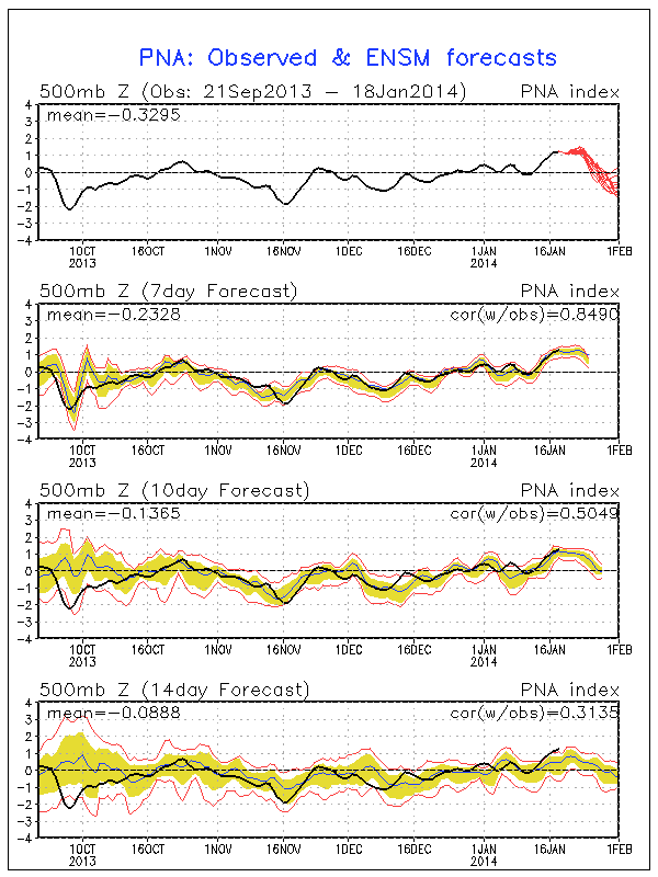
The MJO (Madden-Julian Oscillation) is predicted to weaken and stay inactive for the next one to two weeks, so no help there as far as predicting a possible solution. Warm water anomalies. There has been a lot of talk about what has been creating this persistent pattern with the ridge off our coast. What is partially to blame is the warm water anomalies off the Pacific West coast. A solid series of storms would disrupt these warm anomalies which should prevent the ridge from reloading this persistence pattern we have been stuck in for the last 13 months.
A series of storms for the end of January and the beginning of February could be a game breaker for how our March and April plays out. Keep your finger crossed…