This post first appeared on NASA Observatory and was written by Lindsey Doermann.
Hurricane Helene intensified as it approached Florida’s Big Bend in fall 2024, ultimately making landfall as a Category 4 storm at 11:10 p.m. Eastern Time on September 27. Even while its center was still over the Gulf of Mexico, the hurricane had begun producing devastating outcomes on land. A predecessor rain event and then the main storm system brought heavy precipitation to southern Appalachia starting on September 25. Deadly and destructive flooding occurred as a result in eastern Tennessee, western Virginia, and North Carolina, among other areas.
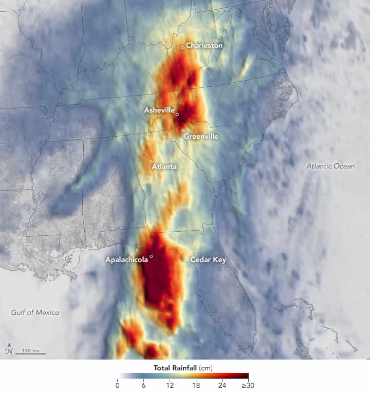
This map shows rainfall accumulation over the three-day period ending at 7:59 p.m. Eastern Time (23:59 Universal Time) on September 27, 2024. These data are remotely sensed estimates that come from IMERG (the Integrated Multi-Satellite Retrievals for GPM), a product of the GPM (Global Precipitation Measurement) mission, and may differ from ground-based measurements. For instance, IMERG data are averaged across each pixel, meaning that rain-gauge measurements within a given pixel can be significantly higher or lower than the average.
In Asheville, North Carolina, a total of 13.98 inches (35.52 centimeters) of rain fell from September 25 to 27, according to National Weather Service records. The storm swamped neighborhoods, damaged roads, caused landslides, knocked out electricity and cell service, and forced many residents to evacuate to temporary shelters. Record flood crestswere observed on multiple rivers in the state. Flooding was widespread across the southern Appalachians; preliminary rainfall totals neared or exceeded 10 inches (25 centimeters) in parts of Georgia, North Carolina, South Carolina, Tennessee, and Virginia.
On the coast of Florida, the heaviest rainfall was concentrated west of the storm’s center, in and around the town of Apalachicola. For hurricanes in the gulf, heavy rainfall typically occurs east of the storm’s center, where counterclockwise rotation brings in the most moisture from the water body. In the case of Helene, a frontal boundary over the Florida Panhandle interacted with the circulation to concentrate the highest totals west of the center, noted Steve Lang, a research meteorologist at NASA’s Goddard Space Flight Center.
Parts of the Florida coast receiving less rain were not spared from flooding, however. Several Gulf Coast cities and towns, including Cedar Key and Tampa, were affected by storm surge.
NASA Disasters Response Coordination System has activated to support agencies responding to the storm, including FEMA and the Florida Division of Emergency Management. The team will be posting maps and data products on its open-access mapping portal as new information becomes available about flooding, power outages, precipitation totals, and other topics.
NASA Earth Observatory image by Lauren Dauphin, using IMERG data from the Global Precipitation Mission (GPM) at NASA/GSFC. Story by Lindsey Doermann.