The NOAA just released its outlook for April 2025. While winter is ending, big snow is not unheard of in April. Let’s see what the NOAA claims are in store next month. Fingers crossed!
TL;DR:
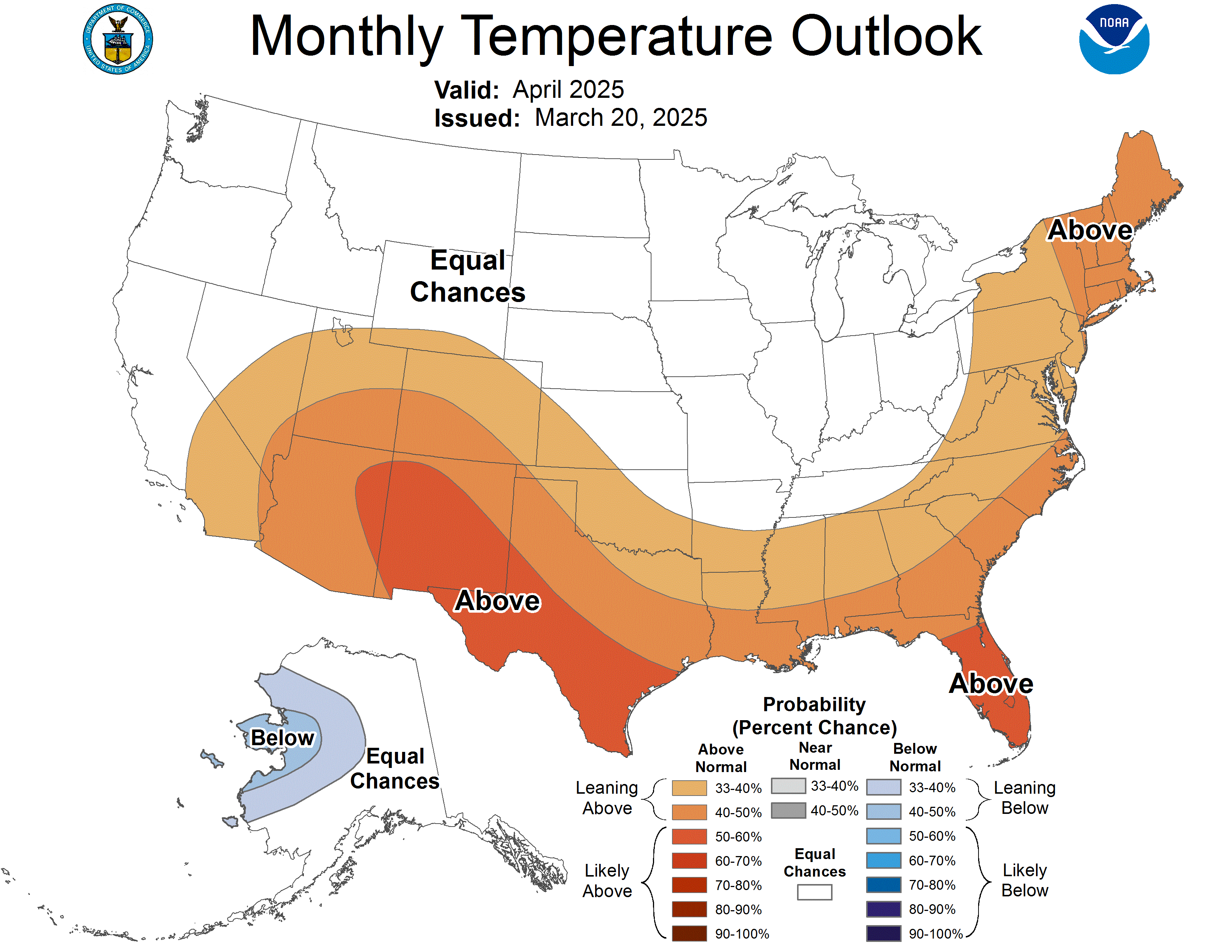
- Temperatures: Above normal in the Southwest, Central Rockies, and Eastern Seaboard; cooler in central Alaska.
- Precipitation: Above normal in the Pacific Northwest and Northern Rockies; below normal in Southern California, the Southwest, and Gulf Coast.
- Snow: Best chances in the Pacific Northwest and Northern Rockies.
Here’s a more in-depth summary of the outlook, with the full-text discussion at the bottom:
Temperature Outlook
-
Alaska: Expect cooler than normal temperatures in central western Mainland Alaska.
-
Western US:
-
Above normal temperatures likely in the Southwest, southern Great Basin, and Central Rockies.
-
Pacific Coast areas have equal chances of above, near, or below normal temperatures.
-
Southern California may see slightly above normal temperatures.
-
-
Northern US: Equal chances of above, near, or below normal temperatures from the Pacific Northwest to the Northern Plains and Great Lakes region.
-
Eastern US: Above normal temperatures favored along the Eastern Seaboard and Northeast.
Precipitation Outlook
-
Alaska: Slightly below normal precipitation expected in coastal areas of southwestern Mainland Alaska.
-
Pacific Northwest: Above normal precipitation favored, including the Columbia Basin and Northern Rockies.
-
California: Below normal precipitation likely in Southern California.
-
Western Interior: Below normal precipitation expected from the central/southern interior West to western areas of the Central and Southern Plains.
-
Central US: Above normal precipitation favored from the Central Mississippi Valley to the central Great Lakes region.
-
Southern US: Below normal precipitation likely for much of the Gulf Coast region to the southern Atlantic coast.
Snow Outlook
-
Best chances for snow:
-
Pacific Northwest
-
Northern Rockies (Western Montana, Western Wyoming, Idaho)
-
Columbia Basin
-
-
Less likely to see significant snow:
-
Southern California
-
Desert Southwest
-
Southern Rockies
-
Central and Southern Plains
-
Remember that this is a general outlook for the month, and specific storm systems may still bring snow to areas not favored for above-normal precipitation.
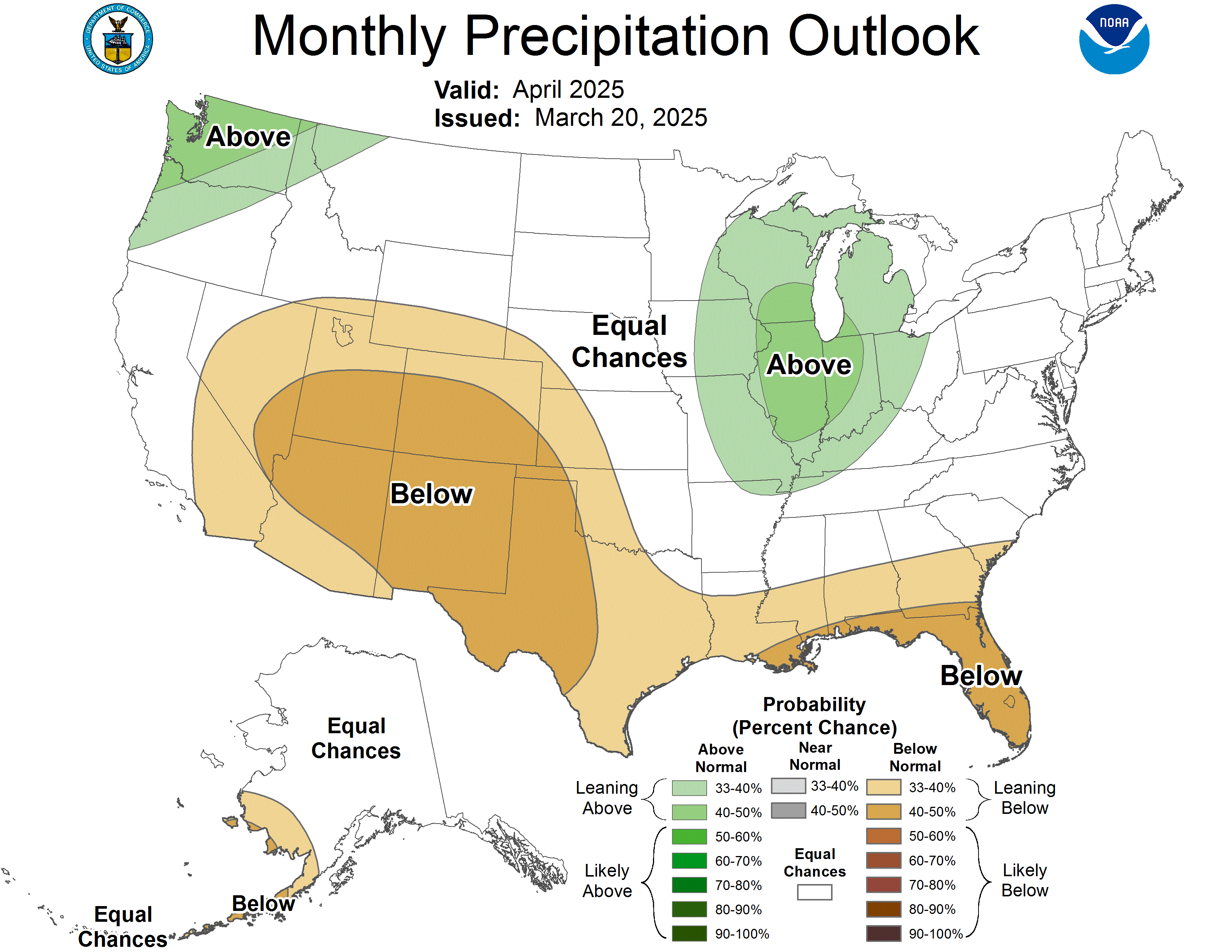
30-DAY OUTLOOK DISCUSSION FOR APRIL 2025

The April 2025 Monthly Outlook is made as current La Niña conditions are
transitioning to neutral El Niño Southern Oscillation (ENSO) conditions. The
most recent weekly Niño 3.4 sea surface temperature (SST) anomaly is at 0.0
degrees Celsius. SST anomalies in the central Pacific Ocean remain negative,
while SST anomalies in the eastern Pacific Ocean are now positive. Outgoing
longwave radiation (OLR) anomalies are positive in the central tropical Pacific
Ocean near the Date Line, indicating below-average convection and cloud cover,
while negative OLR anomalies were observed over the Eastern Pacific. The
pattern of suppressed convection over the central tropical Pacific Ocean is
consistent with current La Niña conditions. Recently westerly low-level wind
anomalies were observed over the east-central Pacific Ocean, where easterly
wind anomalies are generally associated with La Niña conditions. Negative
subsurface ocean temperature anomalies in the equatorial Pacific Ocean weakened
significantly in recent weeks, and may be an indicator of a transition to ENSO
neutral conditions. Dynamical model forecasts and the ENSO Outlook predict a
transition to ENSO neutral conditions is likely by the end of April with a
probability of around 75 percent.

On subseasonal timescales, the Madden Julian Oscillation (MJO) is active in
phase 3 with enhanced convection over the Indian Ocean. Dynamical models
generally predict a rapid propagation of the MJO active phase across the
Maritime Continent into the Western Pacific in the next week, with some
uncertainty in the robustness of the MJO signal. Lagged composites indicate
that this active MJO would decrease temperatures over the northern central
Contiguous United States (CONUS) by early April, with potentially cooler
temperatures over parts of the northwestern CONUS later in the month. Impacts
of the MJO were generally considered in the April monthly outlook through
dynamical model forecasts for the week 3-4 period that overlap with the first
half of April. A Sudden Stratospheric Warming (SSW) event was observed recently
over the Arctic, as the polar vortex was displaced and weakened. Impacts of an
SSW are weaker when occurring late in the spring, compared to winter; however,
significant cooling is generally observed over Alaska 30 to 60 days following
the onset of the SSW, largely coinciding with the April Monthly Outlook.
Although weaker impacts may be observed over the CONUS from a spring SSW,
potential impacts include cooling of the northern central CONUS early in April
and cooler temperatures for the Pacific coastal states through the month of
April.

The April temperature and precipitation outlooks were based primarily on
dynamical model and statistical model forecasts. Dynamical model forecasts for
the month of April are from the North America Multimodel Ensemble (NMME). In
addition, the statistical consolidation (Stat CON) includes the following
statistical tools: the Canonical Correlation Analysis (CCA), the Constructed
Analog (CA), and an ENSO OCN tool, that combines the impact of ENSO, based on
the CPC SST consolidation predicted median Niño 3.4 SST anomaly, with the
Optimum Climate Normal (OCN) to represent decadal trends . Daily initialized
forecasts from the Climate Forecast System (CFSv2) dynamical model for April
and the most recent ECMWF and GEFS dynamical model forecasts for the week 3-4
period that overlaps the beginning of the month of April were also considered.
Recent boundary conditions, including coastal SSTs, and soil moisture
anomalies, were additional factors considered.

The April temperature outlook favors below normal temperatures for central
western Mainland Alaska, consistent with dynamical model guidance from ECMWF
and GEFS for early April as well as potential impacts of the recent SSW for
30-60 days following the initial warming on March 9. The NMME model forecasts
generally predict likely above normal temperatures across the CONUS, driven by
dynamical model representations of decadal trends . Although the observed
decadal trend is a significant predictable signal on seasonal timescales,
observed trends  are not uniform across the CONUS. Above normal temperatures are
favored across most of the southwestern CONUS into the southern Great Basin and
Central Rockies, consistent with the Stat CON and CFSv2 model forecasts. Higher
probabilities for above normal temperatures greater than 50 percent in parts of
the Desert Southwest and South Texas are consistent with local temperature
feedbacks to negative soil moisture anomalies. Equal chances (EC) of above,
near and below normal temperatures are indicated for much of the Pacific Coast
with weak probabilities favoring above normal temperatures for Southern
California, in part due to possible impacts of an SSW in March, in addition to
uncertainty in dynamical model forecasts for the first half of the month. Above
normal temperatures are favored across the Southern Plains into the Gulf Coast
region and northward up the Eastern Seaboard, consistent with CFSv2 forecasts.
Elevated probabilities for above normal temperatures over parts of the
Northeast are also supported by decadal trends . A large area of EC is indicated
from the Pacific Northwest into the Northern Plains, the Great Lakes region,
the Midwest, and the Central Mississippi Valley, where some periods of below
normal temperatures are predicted by dynamical models  for early April, possibly
related to an active MJO or a negative Arctic Oscillation associated with the
current SSW.

The April precipitation outlook slightly favors below normal precipitation for
coastal areas of southwestern Mainland Alaska, supported by dynamical model
forecasts from the NMME and by the Stat CON. Above normal precipitation is
favored for parts of the Pacific Northwest, Columbia Basin, and Northern
Rockies, consistent with the CFSv2 forecast and possible remaining impacts of
La Niña. Below normal precipitation is favored for parts of Southern California
and over a large area of the central and southern interior western CONUS
eastward to western areas of the Central and Southern Plains, consistent with
most dynamical model forecasts and the Stat CON. Below normal precipitation is
also favored for much of the Gulf Coast region to the southern Atlantic coast,
consistent with NMME and CFSv2 forecasts. Above normal precipitation is favored
from the Central Mississippi Valley to the central Great Lakes region,
supported by the CFSv2 and the International Multi-Model Ensemble (IMME).

FORECASTER: Dan Collins

The climatic normals are based on conditions between 1991 and 2020, following
the World Meteorological Organization convention of using the most recent 3
complete decades as the climate reference period.  The probability anomalies
for temperature and precipitation based on these new normals better represent
shorter term climatic anomalies than the forecasts based on older normals.

An updated monthly outlook... for Apr will be issued on Mon March 31 2025

These outlooks are based on departures from the 1991-2020 base period.
$$