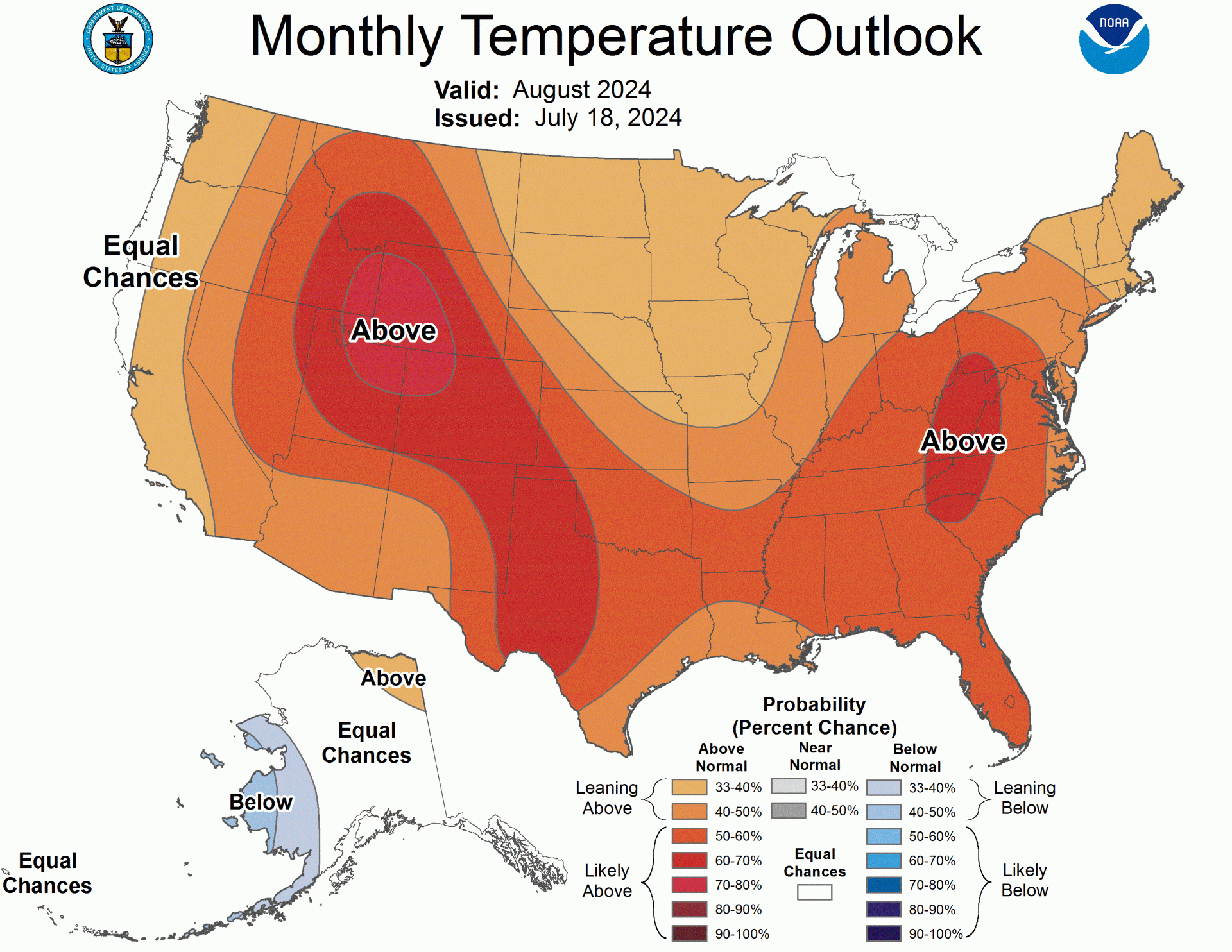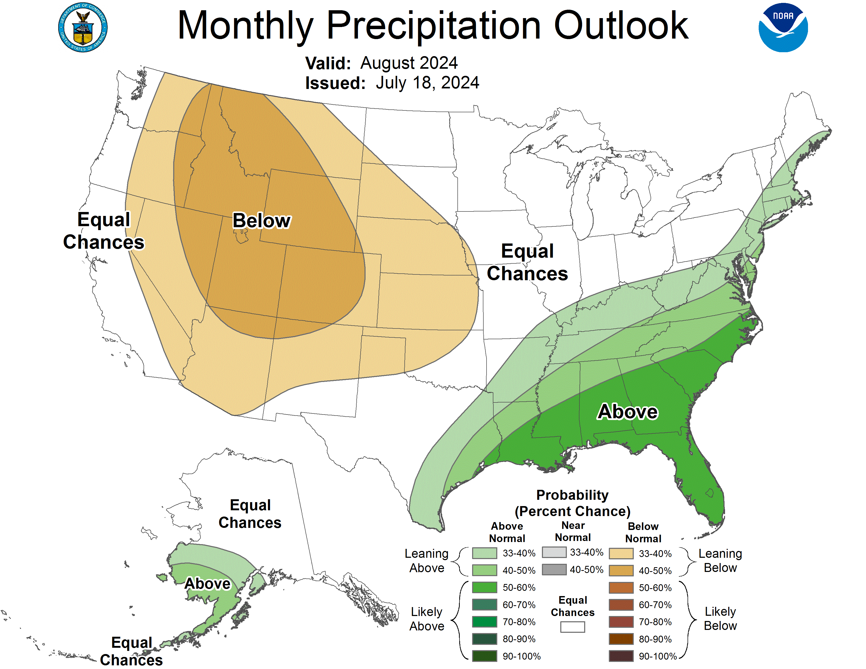
Yesterday, July 18, the NOAA released its outlook for August 2024. The forecast indicates a month characterized by generally above-normal temperatures across most of the contiguous United States, influenced by various climate factors, including the potential emergence of La Niña conditions. The forecast predicts significant regional variations, with the Southwest likely experiencing notably higher temperatures and below-normal precipitation. In contrast, the Southeast, Lower Mississippi Valley, and parts of the Mid-Atlantic are expected to see above-normal precipitation, supported by predictions of an active Atlantic hurricane season. Overall, the outlook highlights a mix of warmth and moisture, with specific areas facing unique climatic influences.
- Related: NOAA Winter 2024/25 Early Forecast: La Niña Returns and What That Means For Next Winter’s Ski Season
Below is a simplified summary, and at the bottom of the post is the full NOAA text discussion.
Temperature Outlook:
- Northeast U.S.: Above-normal temperatures are expected, especially in the Central Appalachians, due to low soil moisture.
- Southeast U.S.: Generally, above-normal temperatures are anticipated, supported by warm waters around Florida.
- Midwest: Slightly above-normal temperatures favored, but significant variability is expected.
- Great Plains: Mixed expectations with a break in warmth; probabilities for above-normal temperatures exceed 70% in parts of the north-central Rockies.
- Southwest U.S.: Significantly above-normal temperatures are likely, but some models show lower probabilities.
- West Coast: Equal chances of below, near, and above-normal temperatures due to marine influences.
- Alaska: Below-normal temperatures are expected in the southwest, while the northeast may see above-normal temperatures.
Precipitation Outlook:
- Southeastern U.S.: Above-normal precipitation is likely for the southeast third of Texas, Lower Mississippi, Tennessee Valleys, and much of the Southeast.
- Mid-Atlantic: Above-normal precipitation is expected from the Mid-Atlantic region to southern and central New England.
- Western U.S.: Below-normal precipitation is favored for much of the western half of the country.
- Southwestern U.S.: Minimal chances for below-normal precipitation, with some support for wetter conditions in Arizona and New Mexico.
- Alaska: Above-normal precipitation is likely for the southwestern Mainland and eastern Aleutians.

30-DAY OUTLOOK DISCUSSION FOR AUGUST 2024

The August 2024 monthly temperature and precipitation outlooks are based on
various climate factors. These include the phase of ENSO, the Madden-Julian
Oscillation (MJO), dynamical and statistical model guidance, and boundary
conditions such as coastal sea-surface temperatures (SSTs) and recent soil
moisture anomalies. Historical temperature and precipitation trends  were also
considered, as were recent observations and the latest Weeks 3-4 temperature
and precipitation outlooks which extend through the 9th of August.

Currently, ENSO-neutral conditions are observed but La Niña is favored to
emerge during August-September-October (ASO) 2024 (70% chance) and persist into
the Northern Hemisphere winter (79% chance) during November-December-January
(NDJ) 2024-25. The latest weekly Niño 3.4 index was +0.3 deg C. Mostly
near-normal SSTs prevailed across the near-equatorial eastern and east-central
Pacific, while temperatures below the surface in these regions were
below-normal. Convection was near-normal to slightly above normal across
Indonesia and the vicinity of the Date Line. Collectively, these
ocean-atmosphere indicators reflected ENSO-neutral. The MJO signal showed
little eastward propagation this past week between the Indian Ocean and
Maritime Continent regions, and the OLR plots displayed considerable
disorganization. Impacts from both ENSO and the MJO for the month of August are
expected to be minor.

The North American Multi-Model Ensemble (NMME) and Copernicus Climate Change
Service (C3S) multi-model, also known as the International Multi-Model
Ensemble, and their constituent model inputs served as the dynamical basis for
the monthly outlooks. The Constructed Analog on Soil Moisture Tool (CA-SMT),
ENSO composites and regressions, and historical trends  served as the
statistical basis for the outlooks. Three consolidation tools were used that
skill-weighted and calibrated the dynamical models  (NMME-CON), the statistical
models (STAT-CON), and a Final-CON which consolidated the other two CONs.

Boundary conditions (coastal SSTs and recent soil moisture anomalies) were also
considered in the construction of the monthly temperature and precipitation
outlooks for August 2024. SSTs were below-normal near the coasts of northern
and western Alaska, mostly near-normal near the West Coast, and above-normal
along the Gulf and Atlantic coasts. Recent areas of relatively low soil
moisture include the Ohio and Tennessee Valleys, the Central and Southern
Appalachians, portions of the Mid-Atlantic region, the Carolinas, the Rio
Grande Valley of Texas, and large portions of the northwestern Lower 48 states.
In contrast, recent areas of relatively high soil moisture include from the
north-central states to the central Great Lakes region (due to frontal activity
and thunderstorm clusters), and eastern Texas and much of the Lower Mississippi
Valley, primarily due to the passage of former Hurricane Beryl on July 8-9.
NOAA’s Atlantic Seasonal Hurricane Outlook calls for a well-above average
season this year, which puts the Gulf and East Coasts at an increased risk of
impacts from tropical storms and hurricanes.

The temperature outlook for August 2024 favors above-normal mean temperatures
over nearly all of the contiguous U.S. (CONUS). This is supported by the three
consolidation (CON) tools, CFS, and the C3S. A majority of the tools, including
the NMME PAC, depict a relative weakness and/or break in the favored warmth
across portions of the Great Plains and Mississippi Valley, which is consistent
with significant climate variability observed so far this summer. Maximum
probabilities favoring above-normal temperatures exceed 70% over portions of
the north-central Rockies, supported by much of the model guidance and the
expected late-season influence of dry soils. This is a relatively dry time of
the year for this area. For the Southwest, the C3S and its inputs are confident
of significantly above-normal temperatures and below-normal total
precipitation. Depending upon the speed of the anticipated transition of
ENSO-neutral to La Niña later this summer, some of the favored dryness across
the Southwest may be related to the typically dry La Niña footprint over this
region.  With other model solutions not being quite as confident as the C3S,
suggesting lower probabilities for above-normal temperatures would be prudent
across the Southwest. Historical trends  also support elevated probabilities for
warmer-than-normal temperatures over this region and the southern High Plains
during August. Across the north-central states, odds are only slightly tilted
towards above-normal temperatures due to several factors. These factors include
adequate model and tool support, the expectation of significant variability
continuing in the future, and the anticipated continued presence of very moist
soils. Over the eastern CONUS, there is plenty of dynamical model support for
the favored above-normal temperatures, with limited statistical support.
Relatively warm water surrounds the Florida Peninsula and enhances the chances
for anomalous warmth. Odds surpass 60% over an area centered on the Central
Applachians, in part due to low soil moisture. Near the immediate West Coast,
Equal Chances (EC) of below-, near-, and above-normal temperatures are favored
in August, attributed to the influence of the marine layer.

For Alaska, odds are tilted towards below-normal temperatures over southwestern
sections of the state, largely due to the nearby Bering Sea and its unusually
cold water for this time of year. The favored below-normal temperatures are
also backed by a regression tool which regresses temperature anomalies against
the standardized Niño 3.4 index for the July-September season (with the central
month, August, being our target period). For the remainder of the state, a
subjective consensus of models and tools suggests a weak tilt towards
above-normal temperatures for the northeast portion of the Mainland and EC
elsewhere.

The precipitation outlook for August 2024 favors above-normal precipitation for
the southeastern third of Texas, much of the Lower Mississippi and Tennessee
Valleys, southern Ohio Valley, the Southeast, Southern Appalachian mountains,
and from much of the Mid-Atlantic region to southern and central New England.
This is supported in large part by the three CON tools, CA-SMT, CFS, and C3S.
Maximum probabilities for above-normal precipitation chances surpass 50% for
most of the Gulf Coast and Southeast coast states. The last 9 runs of the CFS
model favor above-normal precipitation over much of the same general area. This
anticipated relatively wet pattern is also deemed judicious given NOAA’s
seasonal hurricane outlook which favors a very active Atlantic hurricane season
in 2024. In contrast, below-normal precipitation is favored for much of the
western half of the CONUS. Most of the support for the relatively dry outlook
comes from the three consolidation tools, C3S, CFS, Meteo-France model, and the
UKMO model. For several of the last 9 daily CFS runs, wetter-than-normal
conditions have been predicted by the CFS model over the northwestern CONUS,
which is a significant deviation from most other tools and was therefore
discounted. Minimal probabilities favoring below-normal precipitation amounts
are indicated across most of Arizona and New Mexico, given the early and
consistent start to the Southwest monsoon and potential backdoor cold front
activity that often affects New Mexico in particular.

In Alaska, there is a tilt in the odds towards above-normal precipitation for
the southwestern Mainland, the Alaska Peninsula, and the eastern Aleutians.
This has the support of many of the C3S inputs, including the German and
Canadian models (DWD and CMCC, respectively), to name a few. The latest 3 runs
of the CFS also lend some support to the favored above-normal precipitation
chances across southwestern Alaska. Elsewhere across Alaska and the Lower 48
states, EC is favored.