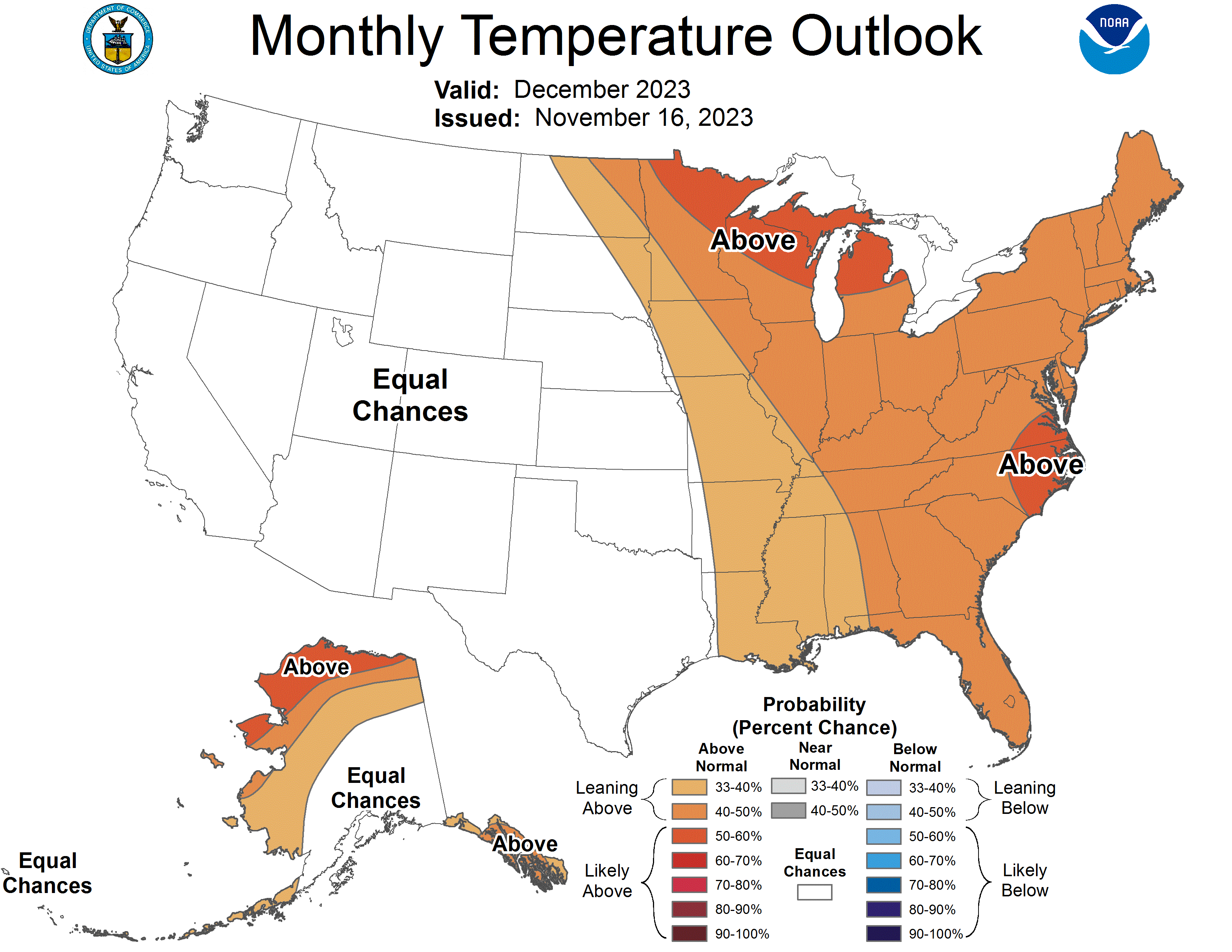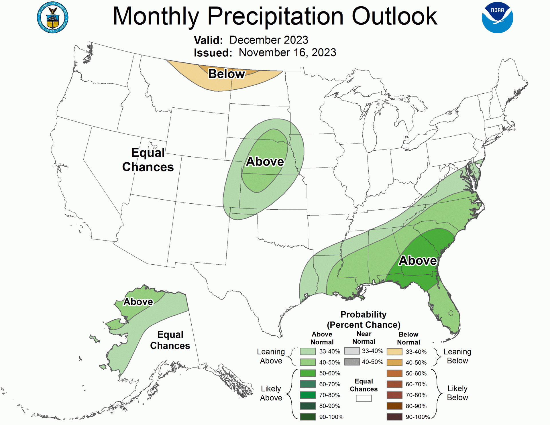
The NOAA just released its outlook for December 2023. With ski season well underway, we’re all hoping for plenty of snow to build those bases and get us stoked for the rest of the season. Is that what we’ll get?
Below is an AI generated summary of the NOAA text discussion for those of us unfamiliar with meteorological jargon:
The December 2023 weather forecast can be summarized as follows for those not familiar with weather terminology:
1. General Conditions: The forecast is influenced by El Niño, a climate pattern characterized by warmer ocean temperatures in the Pacific. This affects weather globally.
2. United States Temperature Forecast:
-
- Eastern U.S. (from the Northern Great Plains to the Lower Mississippi Valley and eastward to the coast): Likely to experience higher than usual temperatures.
- Upper Mississippi Valley and Great Lakes: Very high chances of warmer temperatures.
- Great Plains to the Rockies: Uncertain temperature forecast, could go either way.
- Southwest: Generally expected to be warm.
- Four Corners region: Likely to have lower than normal temperatures.
- Northern California and the Pacific Northwest: Higher temperatures are possible, but there’s some uncertainty.
- Alaska: Western and Northern regions are expected to be warmer than usual due to less sea ice and warmer sea temperatures.
3. United States Precipitation Forecast:
-
- Southeast U.S.: High chances of more rain than usual.
- From Texas to South Dakota: Wet conditions expected at the start of the month.
- Northern Plains: A trend towards more rain.
- Western U.S.: Variable conditions, but leaning towards normal rainfall levels.
- Northern Great Plains: Likely to see less rain than usual for December.
- Western and Northern mainland Alaska: Expect more rain than usual.
Overall, the forecast indicates a warmer December for many parts of the U.S., especially in the east and parts of Alaska. The Southeast U.S. might experience more rainfall, while the Northern Great Plains are expected to receive less than usual. The forecast is based on a combination of current sea temperatures, historical weather patterns, and advanced weather modeling.

Below is the NOAA’s discussion in full:
30-DAY OUTLOOK DISCUSSION FOR DECEMBER
2023 El Nino conditions are currently observed, and equatorial sea surface temperatures (SSTs) are above average across the central and eastern equatorial Pacific Ocean. The tropical Pacific atmosphere is consistent with El Niño, and as such we expect El Niño to be the dominant tropical-based teleconnection for December. The Madden Julian Oscillation (MJO) recently weakened according to the Real-time Multivariate (RMM) Index and CPC’s 200-hPa velocity potential index, but is forecast to strengthen later in November. A strengthening JO could result in more variability over the Western CONUS during through mid-December. In addition to these influencing factors, the December Temperature and Precipitation Outlooks consider local SST anomalies, dynamical model guidance from the North American Multi-Model Ensemble (NMME), Copernicus model suite (C3S), and the Climate Forecast System version 2 (CFSv2), as well as statistical models that include the influence of trend and ENSO. Week 3-4 outputs from CFSv2, ECMWF, and GEFSv12 from mid-November for the early part of December were also considered.
The December 2023 Temperature Outlook favors a broad area of above normal temperatures for the eastern CONUS, from the Northern Great Plains to the Lower Mississippi Valley and eastward to the coast. The highest probabilities for above-normal temperatures are over the Upper Mississippi Valley and Great Lakes, where the impacts of trend and ENSO are maximized. NMME outputs support the area of above-normal temperatures east of the Mississippi River, but with lower probabilities than the statistical tools (CCA, CA, OCN). Across the Great Plains to the Rockies, trends are weak and the dynamical model signals are mixed, so Equal Chances (EC) is indicated. OCN indicates warmth across the Southwest while ENSO-OCN favors below-normal temperatures in the Four Corners region. Lagged composites of predicted MJO activity would favor a highly variable pattern across the Rockies, further contributing to the EC outlook there. Across northern California and the Pacific Northwest, the statistical tools and dynamical models both indicate above-normal temperatures, but the spatial patterns in the tools are not aligned, indicating uncertainty in the output and likely uncertainty in the forcing, so EC is indicated there. Across Alaska, recent SST observations are showing above-normal SSTs and lower sea ice coverage, both of which would favor above-normal temperatures for western and Northern Alaska. NMME and Week3/4 model guidance also support broad scale above-normal temperatures across most of Alaska, though tempered by mean troughing associated with the predicted phases of MJO early in the month.
The strongest signal for above-normal precipitation is across the Southeast, consistent with NMME and statistical tool guidance, as well as Week-3/4 guidance. A storm track across the Southeast is consistent with the winter time response to El Niño. The ENSO-OCN tool indicated a wet start to the month from Texas to South Dakota, and the OCN indicates a strong wet trend in the Northern Plains. MJO composites indicate variability in storm track during the month, with early month troughing across the Western CONUS that evolves into an enhanced jet by mid month. That transition and progressive pattern results in EC over most of the Western CONUS, though north of the mean trough likely early in the month is an area across the Northern Great Plains where below-normal precipitation is likely for the month as a whole. Mean troughing to the west of Alaska from MJO composites, trends, and SST patterns indicate above-normal precipitation for western and northern mainland Alaska is the most likely outcome.