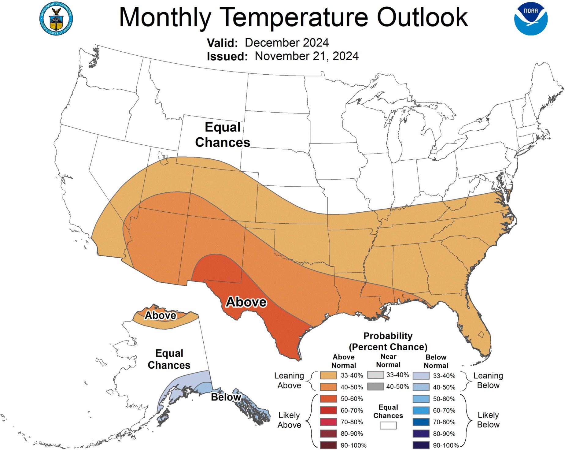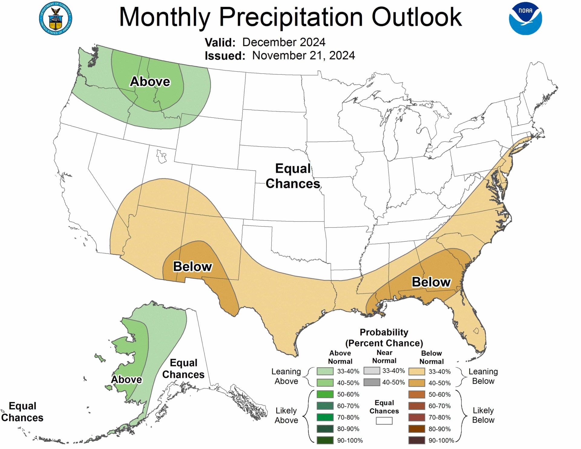
The Climate Prediction Center’s seasonal outlook for December 2024 brings mixed news for skiers and boarders.
TL;DR: The December 2024 weather outlook favors good snow conditions for Western ski resorts, particularly in the Pacific Northwest and Northern Rockies, while Eastern resorts face uncertainty with a slight lean toward drier conditions.
Temperature Trends
A major pattern shift is expected in late November, bringing cold air from Canada into the central and eastern U.S. Early December will likely see below-normal temperatures from the Great Plains to the East Coast, particularly in the Great Lakes and Northeast regions.
By mid-December, temperatures may rise above normal across the central and eastern U.S. The Southeast, Lower Mississippi Valley, Southern Great Plains, and Southwest have increased chances of above-normal temperatures.

Precipitation Outlook
The Pacific Northwest and Northern Rockies have higher probabilities of above-normal precipitation, which is good news for skiers and snowboarders in these areas. The Southeast, Gulf Coast States, and parts of the East Coast up to southern New England may experience below-normal precipitation.
Much of the central U.S. is uncertain, with equal chances of below, near, or above-normal precipitation.
Regional Highlights
Western ski resorts: The Pacific Northwest and Northern Rockies have the best outlook for snowfall, with increased chances of above-normal precipitation.
Eastern ski resorts: The forecast is less certain, with a slight lean towards below-normal precipitation along the East Coast.
Midwest and Northeast: Equal chances of below, near, or above-normal temperatures, with potential for cold spells early in the month.
Factors Influencing the Forecast
La Niña conditions are expected to develop by the end of December, which could impact weather patterns. The Madden-Julian Oscillation (MJO) may influence temperature and precipitation patterns throughout the month.
For winter sports enthusiasts, this forecast suggests potentially favorable conditions in the Western mountains, while the outlook for Eastern resorts is less certain. Remember that local conditions vary, and short-term weather patterns may deviate from these monthly projections.
The full NOAA discussion is below:
Prognostic Discussion for Monthly Outlook
NWS Climate Prediction Center College Park MD
830 AM EST Thu Nov 21 2024


30-DAY OUTLOOK DISCUSSION FOR DECEMBER 2024

The December 2024 Temperature and Precipitation Outlooks are based on: the
Weeks 3-4 model guidance, the North American Multi-Model Ensemble (NMME), and
International Multi-Model Ensemble (IMME), the consolidation (combination of
statistical and dynamical tools), consideration of potential Madden Julian
Oscillation (MJO) influences, and decadal trends . Although El Niño Southern
Oscillation (ENSO)-neutral conditions continue, below-average sea surface
temperature anomalies are observed across the east-central Pacific. La Niña is
favored to develop by the end of December and La Niña composites were a factor,
especially in the precipitation outlook.

During late November, a major pattern change is forecast as an amplified
500-hPa ridge over Alaska results in surface high pressure with anomalous cold
shifting south from Canada into the central and eastern contiguous U.S.
(CONUS). By the beginning of December, the GEFS and ECMWF ensemble means are in
good agreement and consistent that below-normal temperatures extend from the
Great Plains to the East Coast. The latest week 3-4 GEFS (valid December 5-18)
favors below-normal temperatures continuing across the Great Lakes and
Northeast. Lagged MJO composites would favor a flip to above-normal
temperatures across the central and eastern CONUS by mid-December. Due to an
expected variable temperature pattern during December, equal chances (EC) of
below, near, or above-normal temperatures are forecast across the Northern
Great Plains, Midwest, and Northeast. The week 3-4 models, NMME, consolidation,
and decadal trends  support increased above-normal temperature probabilities
across the Southeast, Lower Mississippi Valley, Southern Great Plains, and
Southwest. The largest above-normal temperature probabilities (more than 50
percent) are forecast for the Rio Grande Valley and southern New Mexico where
the strongest warm signal exists in the consolidation tool. EC is forecast for
the Pacific Northwest, Northern Rockies, and much of California due to a weak
signal in the NMME.

The NMME, consolidation, and any influence from La Niña favor below-normal
precipitation across the Southeast, Gulf Coast States, and Southeast. This
favored dryness extends northward along the East Coast to the Mid-Atlantic and
southern New England based on the NMME and daily CFS model runs. However, there
is only a slight lean towards below-normal precipitation for portions of the
eastern CONUS since an amplified 500-hPa trough over eastern North America
early in the month would favor multiple low pressure systems tracking either
along or offshore of the East Coast. Below-normal precipitation probabilities
are also lower across the Florida Peninsula as an eastward propagating MJO over
the Western Hemisphere could eventually lead to a more active southern stream
with enhanced precipitation. In addition, the daily CFS model runs have less
support for below-normal precipitation for that part of the Southeast. Week 3-4
model output, most inputs to the NMME, and La Niña composites support elevated
above-normal precipitation probabilities for the Pacific Northwest and Northern
Rockies. A large spatial extent of EC is forecast for the remainder of the
CONUS due to a weak model signal and limited skill at this time lead for a
monthly precipitation outlook.

The increased chances of above (below)-normal temperatures forecast for the
North Slope (southeastern Alaska) are supported by the NMME and consolidation
tool. Lagged MJO composites would also favor below-normal temperatures across
southeastern Alaska during mid-December. The favored wetness across western and
northern Mainland Alaska is based on the NMME and also consistent with decadal
trends.

FORECASTER: Brad Pugh

The climatic normals are based on conditions between 1991 and 2020, following
the World Meteorological Organization convention of using the most recent 3
complete decades as the climate reference period.  The probability anomalies
for temperature and precipitation based on these new normals better represent
shorter term climatic anomalies than the forecasts based on older normals.

An updated monthly outlook... for Dec will be issued on Sat November 30 2024

These outlooks are based on departures from the 1991-2020 base period.
$$