This post first appeared on the climate.gov ENSO Blog and was written by Emily Becker
La Niña conditions emerged in the tropical Pacific in December. There’s a 59% chance La Niña will persist through February–April, followed by a 60% chance of neutral conditions in March–May. Read on for the recent observations that led us to declare the (long-awaited) onset of La Niña and lots of details for current and potential upcoming conditions.
Just the facts, ma’am
A quick briefing, if you’re just joining us—La Niña is one phase of the El Niño/Southern Oscillation (ENSO), a pattern of sea surface temperature and atmospheric changes in the tropical Pacific Ocean. La Niña’s signature is cooler-than-average surface water in the east-central Equatorial Pacific, while its counterpart, El Niño, features warmer-than-average surface water. The atmospheric circulation over the tropical Pacific, called the Walker circulation, exhibits characteristic changes during La Niña and El Niño, so we call ENSO a “coupled” ocean-atmosphere system. ENSO is a seasonal phenomenon, meaning it lasts for several months in a row. The atmospheric changes of ENSO are communicated all around the world, changing temperature and rain/snow patterns in known ways.
Time to get down to brass tacks
Ok! We’ve been expecting La Niña to show up since last spring. While she’s dragged her heels, all the pieces came together this past month.
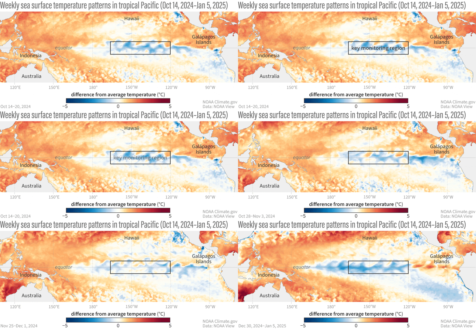
The tropical Pacific sea surface temperature loitered in ENSO-neutral since April 2024, with our primary ENSO monitoring index, the Niño-3.4 index, within 0.5 °C of the long-term average. In December, however, the Niño-3.4 index was -0.6 °C, according to the ERSSTv5, our most reliable long-term sea surface temperature dataset.
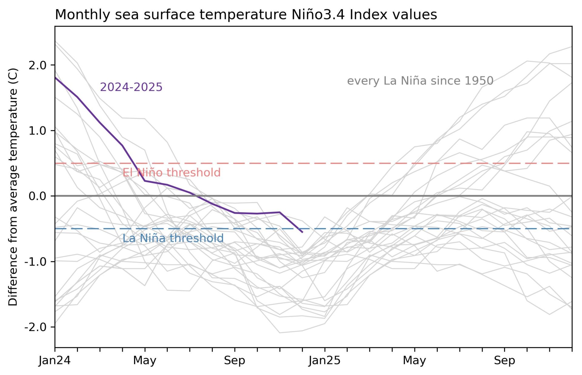
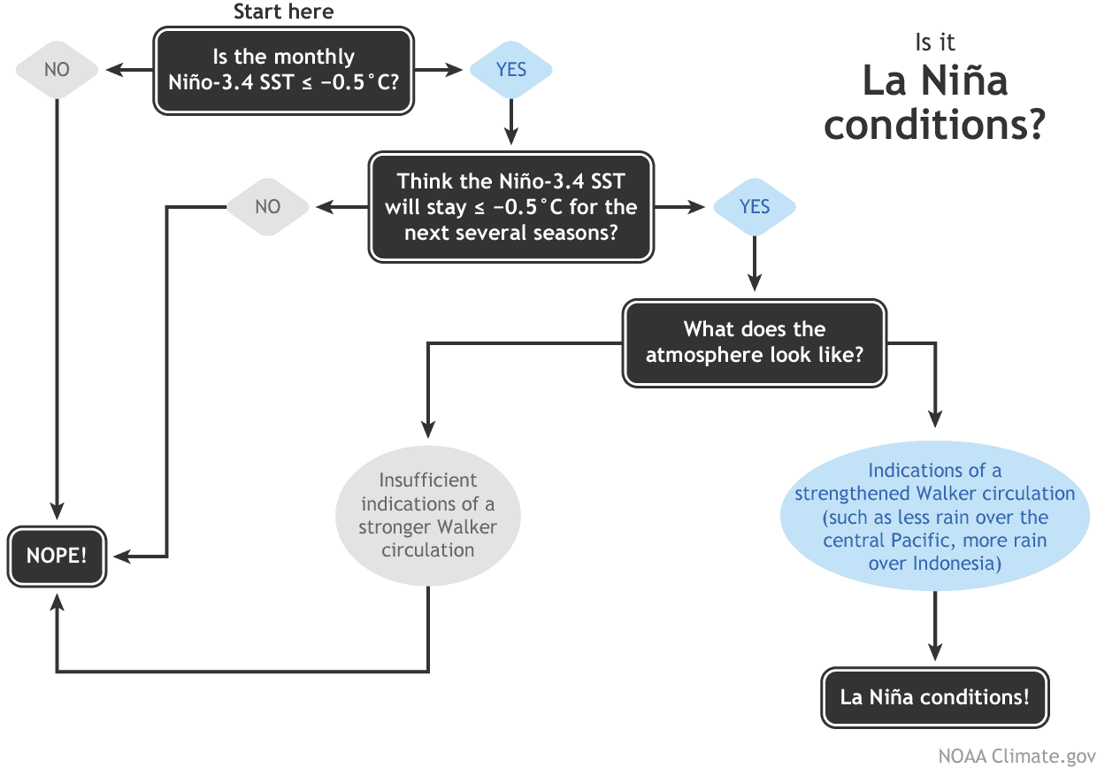
With the Niño-3.4 Index exceeding the La Niña threshold of -0.5 °C, we can move on to the second box on our flowchart—do we think the Niño-3.4 index is going to stay in La Niña territory for the next several seasons? (“Seasons” here means any 3-month-average period.) The consensus among our computer climate models is yes. Also, there is a substantial amount of cooler-than-average water under the surface of the tropical Pacific, which will provide a source for the surface over the next few months.
So, we’re on to the third box, which has actually been checked for a while now (more on that later). The atmosphere has been looking La Niña-ish for months, with stronger-than-average trade winds, more clouds and rain over Indonesia, and drier conditions over the central Pacific—all hallmarks of an amped-up Walker circulation. In December, the Equatorial Southern Oscillation Index (EQSOI), which measures the difference in surface pressure between the western and eastern Pacific, was 1.5 (positive values indicate a stronger Walker circulation). In fact, this is the 5th-strongest December EQSOI in the historical record. Drumroll… La Niña conditions have developed.
Break it down for me
There are a lot of different tidbits I want to tell you about this month, so let’s go Q&A-style.
How long will La Niña last?
b To be categorized as a La Niña event in our historical record, the three-month-average Niño-3.4 Index (the Oceanic Niño Index) needs to stay at least 0.5 °C below average for at least five consecutive, overlapping seasons. Current odds are 60% that the March–May Oceanic Niño Index will be neutral, which would make this event last fewer than five. That’s not to say it’s impossible for this La Niña to last longer, of course—nature is always full of surprises! There is a ~40% chance for La Niña to persist into March-May 2025.
How strong will La Niña be?
It’s very likely this La Niña will be weak, with the Niño-3.4 index unlikely to reach -1.0 °C for a season. This is based on computer model guidance and how late in the year La Niña conditions emerged. ENSO events peak in the northern Hemisphere winter, and there’s just not a lot of time for La Niña to strengthen.
Can La Niña still affect our winter climate?
Sure can, although a weak La Niña tends to have a weaker influence over temperature and precipitation patterns.
Why was La Niña so slow to develop?
The short answer to this is “we don’t yet know.” The emergence of La Niña-like atmospheric conditions before substantial tropical Pacific Ocean surface cooling was unusual, though. The global oceans have been running much, much warmer than average for more than a year, which might have had a hand in La Niña’s delay. When we calculate the Niño-3.4 index but account for the temperature of the tropical oceans (the “Relative Niño-3.4 index”) we get an index that’s been in La Niña territory for months. Only this past year or so has the difference between the traditional and relative Niño-3.4 indexes been so large, and we’re still researching this new measurement and all the implications for ENSO development and impacts in a warmer world.
Has La Niña had any impact on temperature and rain patterns yet?
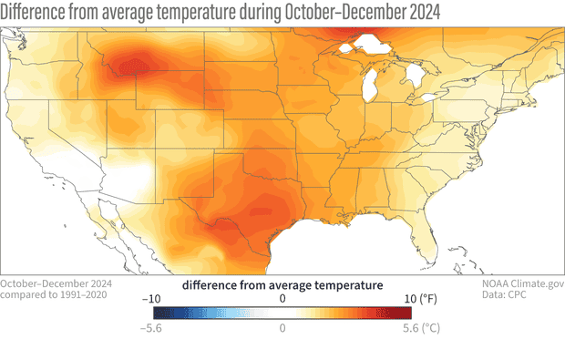
La Niña affects global climate primarily through atmospheric changes, and since the tropical atmosphere has been looking like La Niña for a while, this is a reasonable question! The global climate is incredibly complicated, and even a big factor like ENSO is only one player. Other climate patterns, climate change trends, and random variability can have a strong influence on overall seasonal patterns. That said, it’s interesting that the October–December 2024 temperature and rain/snow patterns over the U.S. resemble the expected patterns from previous La Niña events. See the October–December La Nina temperature and rain/snow maps, and here’s the general page if you would like to poke around.
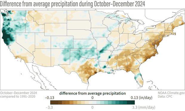
Temperature has a strong influence from climate trends, and the October–December 2024 temperature pattern over the U.S. is clearly dominated by more warmth.
You’re running out of column inches. Any last tidbits?
Thanks for asking! Speaking of La Niña impacts, you might recall there’s a link between La Niña and active Atlantic hurricane seasons. In brief, La Niña reduces vertical wind shear—the difference between near-surface winds and upper-level winds—and makes it easier for hurricanes to grow. Interestingly, the August–October 2024 wind shear in the Atlantic Main Development Region (an area of the Atlantic where hurricanes tend to develop) was the weakest since 1950 (h/t NOAA’s Matt Rosencrans). We can’t say how much of it was related to La Niña, but given the relative Niño-3.4 index has been in La Niña territory for a while now, it’s an interesting situation that bears more research.
The bottom line
As this unusual La Niña progresses, we’ll be here to keep you updated on all things ENSO!